Drought Update
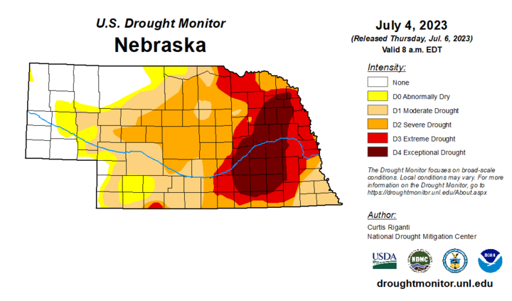
At long last, much of the state received meaningful precipitation over the past week. This led to a 1-category improvement across much of the Panhandle, sections of north-central Nebraska, and sections of east-central and southeastern Nebraska. The result of this improvement is additional eradication of drought in the state with over 25% of the state being free of drought. Furthermore, close to 20% of the state is now free of drought and abnormal dryness. That is the highest percentage of the state free of drought since early February of 2022.
Further east, improvements mean that Lincoln, west Omaha, and surrounding countryside are now back to being classified in extreme drought. The data cutoff was Tuesday morning so the heavy precipitation that fell across other portions of eastern Nebraska the evening of July 4 was not eligible for consideration. If significant rain materializes on Friday in this area, additional improvements may be possible.

Precipitation Update
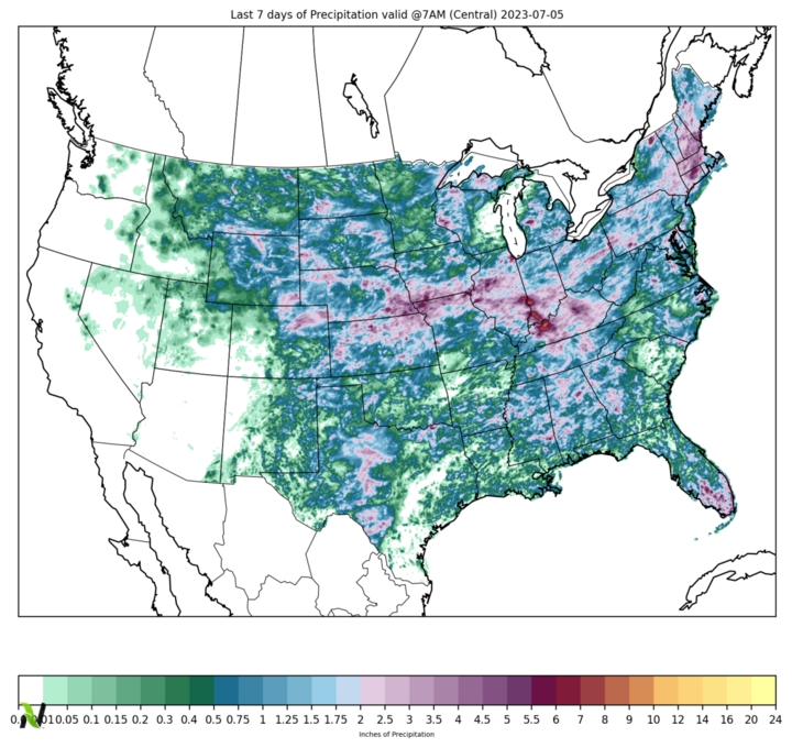
Almost all of the state received moisture over the past week with much of east-central and southeast Nebraska picking up over two inches of rain. Many places in Lancaster and Otoe counties and some locations in Seward, Saline, York and Cass picked up over four inches over the past week. For some places, the rain in the previous seven days was probably not all that far off what had been received all year through last Wednesday.
The good news is the short-term indicators are starting to look better, with some places in southeast Nebraska now showing surpluses in the 30-day timeframe. But this is still just the first step in a long road to full recovery for areas that were in exceptional or extreme drought going into last weekend. Sustained precipitation will be needed to help reduce precipitation deficits and bring meaningful improvement to creeks, streams, ponds, lakes and rivers.

Historic July Maximum Temperatures
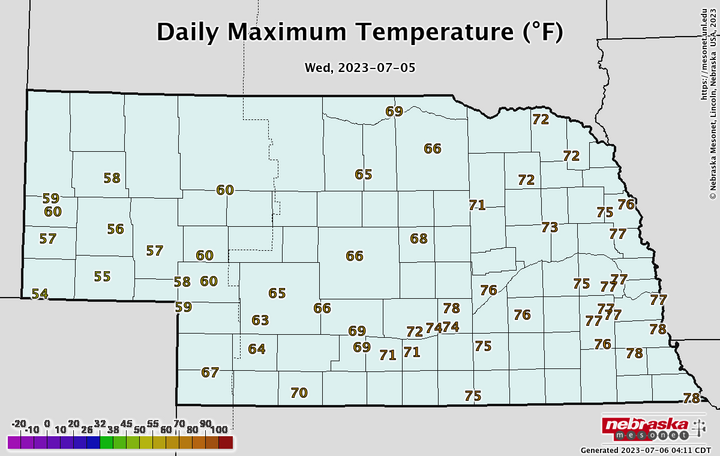
A strong cold front moved through the state between Monday and Tuesday, which helped initiate heavier thunderstorms for parts of Nebraska and brought cooler temperatures to all of the state. Temperatures yesterday were cooler than average statewide but were exceptionally cool in the Panhandle. The past few days may have set global records for temperature but the Panhandle didn't get the memo. This was the result of strong upslope flow that led to overcast, fog and drizzle that persisted for much of the day and kept maximum temperatures at historically low levels for much of this region. Several Mesonet sites didn’t even hit 60 and both Kimball and Sidney would draw the ire of Sammy Hagar for not being above 55.

Vegetation and Crop Condition Update
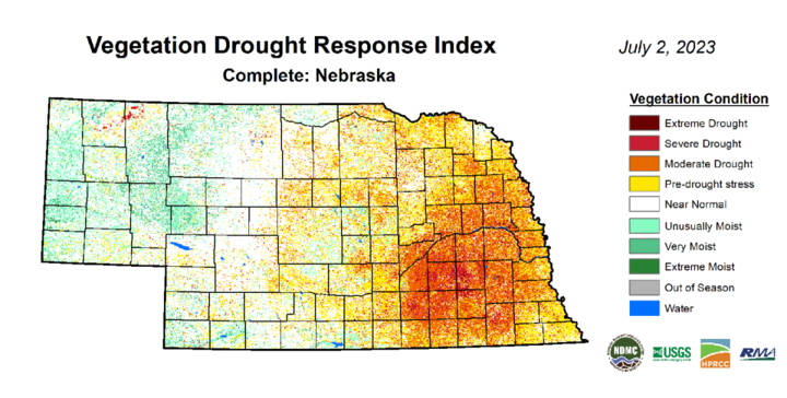
The latest VegDRI map continues to be in good agreement with the U.S. Drought Monitor map, which shows the worst conditions in the area between Aurora and Seward and down into Saline County. Hopefully, the recent rains will help rainfed crops have a chance at a decent season but it’s likely that it was too late for some of the rainfed crops. It will be interesting to see how quickly pastures recover over eastern Nebraska in the coming weeks if rain continues.
Speaking of crops, condition reports contain bad news and good news. Sorghum comes in rated best with 53% good to excellent and 9% poor to very poor. Pastures continue to improve slowly and the percentage of pasture statewide in poor to very poor condition is at 22%, which is the lowest in at least several months. Expect that number to improve if rain continues to fall in eastern Nebraska.
Corn and soybean came in at 17% and 22% poor-very poor, respectively, on the latest NASS update. Those numbers are slightly worse than last week’s report and are quite poor for this point in the season. The update next Monday will be telling for corn and soybean as some fields may have gotten just enough rain to turn things around. If those numbers are still steady on next Monday’s report, that’s an indication that yield and production losses will be likely regardless of how good the rest of the season is.
As we begin wheat harvest season, the percentage of wheat in good to excellent condition comes in at 44% compared to 28% in poor to very poor. This is a decent improvement over earlier in the season and is quite a bit better than at this point last year. Most wheat has yet to be harvested in the state and the 3% harvested as of last weekend is a little behind average. Conditions this week probably aren’t helping matters much.

