Drought Update
Mostly good news to report again this week. We saw upgrading of exceptional drought (D4) to extreme drought across York, Seward, Fillmore, Saline, and Polk counties. This area was probably the epicenter of rapid intensification of drought earlier in the growing season and has seen some of the strongest impacts to dryland crops. Over the past few weeks the combination of sufficient precipitation and cooler temperatures helped bring about some drought relief. Further east, a good section of extreme eastern Nebraska (including all of the Omaha metro) has seen an upgrade to severe drought. Status quo was the rule elsewhere in the state with roughly 32 percent of the state drought-free. The bad news is that the forecast for next week isn’t favorable and some of the recent improvements could be in jeopardy. My guess is this is the last week we see any widespread improvements on the Drought Monitor for a little while. Hopefully I am wrong.
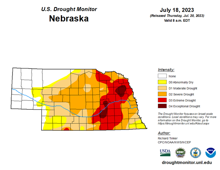
Precipitation Update
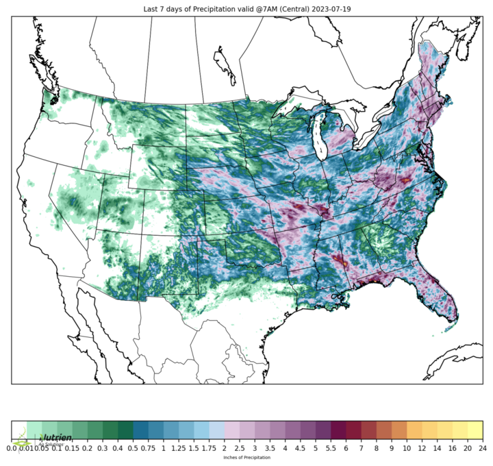
Most places in the state received an inch or more of precipitation, with parts of north central and eastern Nebraska picking up over 2 inches. Drier areas include the southwest corner of the state and the northeastern corner, which has generally missed out on the heaviest precipitation this month.
Cooler Temperatures in July
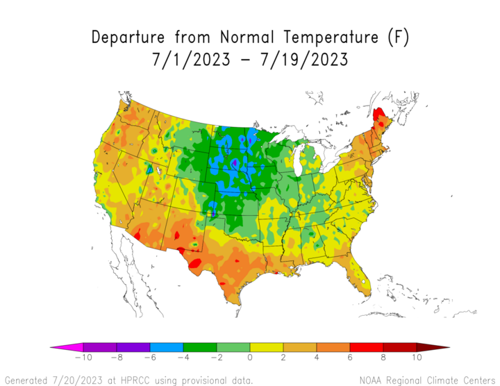
Another reason we have seen recent drought improvement is the cooler than average temperatures that have persisted for most of the month. Most of the state is running 2-4 degrees below long-term averages and most places in eastern Nebraska haven’t been over 90 degrees in over two weeks. The cooler weather has been a benefit to crops entering into or already in critical reproductive stages as well as helping to retain more soil moisture from precipitation. The seasonally cooler temperatures look to be around a few more days before we transition into a hotter and drier period.
Soil Moisture
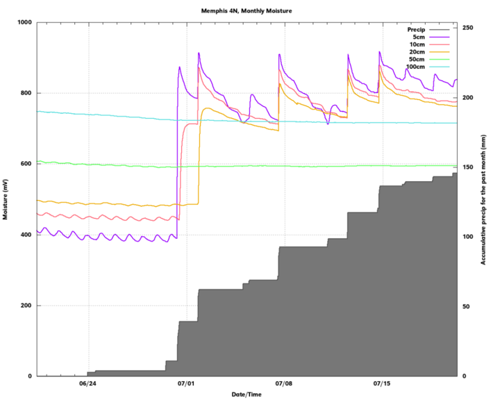
A look at soil moisture from the Nebraska Mesonet shows that there is generally adequate moisture in the top part of the soil, certainly the top foot to 18 inches. However, what concerns me is that we may not have a significant reserve to make it through a longer stretch with no rain and heat. A look at soil moisture from the Memphis 4N site (near the UNL Farm in southeastern Saunders County) shows precipitation over three weeks has yet to make a meaningful difference (or any difference) at 50 cm and 100 cm. Note that the values are in mV (the raw values) so in this case the higher the water content, the higher the voltage. The soil moisture profile may look somewhat different under a crop like corn or soybean where infiltration may have been deeper. But the broader point is I think we have a reserve to help us get through next week. I don’t think most places have the moisture to get through a second week of little rain and heat.
Vegetation and Crop Condition Update
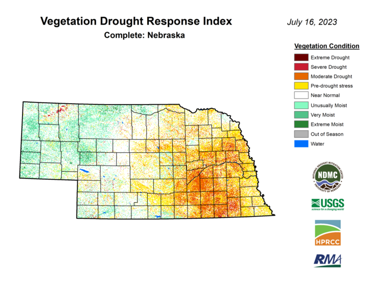
The latest VegDRI map continues to be in good agreement with the U.S. Drought Monitor map, which shows the worst conditions in the area between Aurora and York with broad vegetation stress on rainfed crops in the areas west of Lincoln. Pastures continue to improve slowly and the percentage of pasture statewide in poor to very poor condition is at 13%, lowest in several months. Better news still is that 58% of statewide pasture is in good to excellent condition. Corn and soybean came in at 14% and 19% poor-very poor respectively on the latest NASS update. Those numbers are essentially identical report and while poor for this time of year, it is considerably better than at the same point in 2002 or 2012. Given the recent consistency of that poor-very poor number, it makes sense to conclude that there are simply a number of dryland fields that aren’t going to produce much this year due to the acute dryness through late June, particularly in the areas west of Lincoln. There is definitely potential for a good crop in the traditional rainfed area of southeastern Nebraska though if we can keep the spells of heat to shorter durations the rest of the season.
Corn has started getting into the reproductive stage with 52 percent at silking. This is above the 5-year average of 43 percent. About 60% soybean in the state is considered to be in the blooming stage and 20% are setting pods. Sorghum is starting to head and is in reasonably good shape with 66 percent considered good-excellent but is behind on heading, likely due to the cooler temperatures. The wetter conditions over the past two weeks have hampered an accelerated wheat harvest, with only 21 percent harvested as of now. This is over 30 points behind average and about 35 points behind last year. But harvest should accelerate in the next week with drier weather.
