Highlights
The National Center for Environmental Information (NCEI) preliminary statewide rankings indicate that Nebraska experienced its 37th coldest and 28th driest March since records began in 1895. NCEI calculates that the preliminary state average temperature for March 2023 was 33.4°F, which is 2.4°F below normal (based on the period 1991-2020). March precipitation on an area weighted basis was 0.61 inches according to NCEI, which is 0.67 inches below normal.
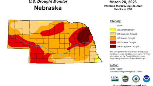
Below normal March temperatures across Nebraska were influenced by a strong upper air trough pattern that kept Arctic/Polar air trapped across the northern United States and resulted in a primary storm track that remained south of the state most of the month. Although precipitation was reported somewhere in the state on 14 of the 31 days in March, the vast majority of these events produced daily precipitation totals under 0.20 inches. Therefore, exceptional drought (D4) continued for parts of east-central and northeast Nebraska, north of the Platte River.
Extreme drought (D3) conditions continue along the Platte River from Wyoming to North Platte, most of southwest Nebraska and a small area within the eastern Sandhill region. Severe drought (D2) covers most of central and eastern Nebraska, while abnormally dry (DO) to moderate drought (D!) conditions prevail across southeast and south-central Nebraska.
Precipitation
The average statewide precipitation value for March is 0.61 inches according to NCEI, which is 0.67 inches below normal according to the current 1991-2020 comparison period. This marks the second consecutive month that the state average precipitation has been below normal after following two consecutive months of above-normal moisture (December and January).
The only new records established at National Weather Service locations across the state occurred on the first day of March at Lincoln and Omaha. Omaha reported 0.98 inches of liquid equivalent moisture, eclipsing the old record of 0.62 inches established in 1969. Lincoln failed to set a liquid equivalent precipitation record on March 1 but did set a new snowfall record of 8.8 inches, breaking the old record of 4.0 inches established in 1939.
Precipitation was recorded somewhere in the state an average of one out of every two days, but individual events were generally under 0.20 inches. Cumulative monthly precipitation totals were under 0.50 inches north of I-80 from the eastern Panhandle through central Nebraska. The majority of cooperative weather observers across the Panhandle, eastern Nebraska and areas south of I-80 reported monthly precipitation totals between 0.50 and 1.00 inches.
Across the eastern half of the state, March precipitation deficits ranged from 0.30 to 1.10 inches below normal. A sizeable area of northeast, east-central and central Nebraska had cumulative precipitation deficits during the month of 0.90-1.20 inches. The western half of the state reported precipitation deficit between 0.30 and 0.90 inches, with the greatest deficits (0.60-0.90 inches) occurring across the northwestern half of the Panhandle. There was a small pocket of surplus moisture (up to 0.30 inches) reported across southwest Nebraska, most of which fell during the March 25-26 snow event.
The most significant precipitation event during March occurred on March 25-26 from the southern Panhandle and southwest Nebraska to east-northeast through the Fremont-Omaha area. Liquid equivalent moisture ranged from 0.10 to 0.75 inches, with snowfall totals of three to eight inches reported in a 20-30 mile path along and north of the I-80 corridor from Lexington to Fremont.
A brief summary of March precipitation events are as follows:
- March 3 — Panhandle/southwest:
- March 7 — western Panhandle:
- March 8 — southeast:
- March 9 — south-central, east-central, southeast:
- March 10 — central, northeast:
- March 11 — southeast half of Nebraska: 0.25-0.50 inches
- March 12 — southeast Nebraska: 0.25-0.50 inches
- March 16-17 — eastern third, Panhandle, southwest, south-central, central:
- March 21-23 — northwest third of state, southeast:
- March 25-26 — southern Panhandle, southwest, west-central, south-central, central, east-central, southeast: 0.10-0.75 inches
The highest liquid equivalent precipitation total reported from real-time cooperative weather observers was 2.18 inches at Hartington and the greatest monthly NERain precipitation total was 1.79 inches at Hastings 1.0 ESE. The cooperative weather observer at Crofton recorded 14.4 inches of snowfall during March, making it the highest cumulative snow total reported from real time observers. The highest monthly snowfall total reported through NERain was at St. Helena 4.1 SW, which recorded 13.5 inches of snowfall.
A preliminary analysis of cooperative observer seasonal snowfall totals through March 31 indicates that at least 12 stations have reported over 50 inches of snowfall this season, with seven locations exceeding 60 inches. Bloomfield leads the seasonal snowfall race with 73 inches, which currently ranks it as the seventh snowiest season based on 75 years of observation data. The winter of 1948-49 was the snowiest season on record for Bloomfield with 95.7 inches of snowfall.
Temperature
Nebraska’s average temperature for March 2023 was 33.4°F, which is 2.4°F below normal. The colder-than-normal conditions across the state slowed dormancy break for native vegetation. Wheat broke dormancy during the second half of the month, nearly two weeks behind the past two years. Preliminary analysis of weather records submitted by NWS cooperative weather observers indicates that the state high temperature of 79°F was set at the Lincoln Airport and Falls City Brenner Field, while the coldest low reported was -2°F at Bushnell 15 S. Thus, the minimum temperature range report during March from real time observation locations was 81°F.
A strong upper air trough pattern situated over the central third of the United States allowed cold air to dominate the western mountain region, the northern/central High Plains region, the upper Mississippi River valley and the western Great Lakes. Across Nebraska, average temperatures were 6-8°F below normal across the southern and northern third of the Panhandle, the northern Sandhill region and western half of northeast Nebraska. Extreme south-central and southeast Nebraska were 2-4°F below normal, with the remainder of the state averaging 4-6°F below normal.
An examination of airport (NWS and ASOS) locations indicates that the western half of the state saw below-normal temperatures between 21 and 25 days during March, while the eastern half of the state had 17-23 days of similar conditions. A deep snowpack over eastern Montana, North Dakota and South Dakota help reinforce the colder-than-normal conditions whenever a frontal boundary passage switched the wind direction to a northerly component. At the end of March, snow depths ranged from just under a foot across east-central South Dakota to over 24 inches across east-central and northeast North Dakota.
Outlook
The Climate Prediction Center (CPC) released their official April climate outlooks on March 31, which indicates that there is a slight chance for below-normal temperatures across the northwestern two-thirds of Nebraska. The southeastern third of the state has equal chances of receiving above-normal, normal, or below-normal temperatures. From a national perspective, CPC indicates below-normal temperatures are favored for the northwestern third of the United States with the highest odds of occurrence are assigned to California, Oregon, the Great Basin, the northern Rockies and the northern High Plains. The highest probability for above-normal temperatures during April encompasses an area from south and east of a line from central Texas east-northeast to northeastern North Carolina.
There are equal chances of above-normal, normal, or below-normal precipitation across Nebraska during April according to CPC. Two distinct areas of above-normal precipitation are indicated by CPC, the northwestern fourth of the United States and a broad area that includes the Great Lakes region, the eastern and central Corn Belt, the middle and lower Mississippi River valley, along with the eastern half of Texas and southeastern third of Oklahoma. Below-normal precipitation is forecast for a small area of the southwestern United States including southern California, Arizona, southern Nevada and northwestern New Mexico. The remainder of the continental United States have been assigned equal odds of receiving above-normal, normal, or below-normal precipitation.
Agricultural Update
Although precipitation events during February were less numerous than December and January, sufficient precipitation fell across the southeastern half of the state during the month to slightly improve statewide top and subsoil moisture estimates. Nebraska Agricultural Statistics Service (NASS) indicates that as of March 27, topsoil moisture was estimated to be 16% very short, 33% short, 46% adequate and 5% surplus. Compared to the last estimate of topsoil moisture conditions on Feb. 27, there was a 3-percentage point deterioration in the very short category, a 2-percentage point improvement in the short and adequate categories, along with a 3-percentage point reduction in the surplus category.
Subsoil moisture estimates showed little change between conditions at the end of February and March according to NASS. Subsoil moisture estimates on March 27 stood at 32% very short, 40% short, 27% adequate and 1% surplus. Compared to conditions on Feb. 27, the very short category deteriorated 2 percentage points, the short category improved 3 percentage points, the adequate category improved 1 percentage points and the surplus category was unchanged.
Nebraska’s winter wheat crop continues to exhibit drought stress, especially across parts of south-central, southwest and the southern half of the Panhandle region. As of March 27, NASS rates the winter wheat crop as 11% very poor, 32% poor, 35% fair, 19% good and 3% excellent. When comparing current condition estimates to a month ago, there was no change in the very poor category, a 3-percentage point decline in the poor category, a 6-percentage point decline in the fair category, a 1-percentage point improvement in the good category and a 2-percentage point improvement in the excellent category. Winter wheat began to break dormancy during the second half of March and will require timely moisture events to minimize further crop deterioration during April.
March Mesonet Extremes
- Highest Air Temperature: 78.1°F, Memphis 4 N (March 30)
- Lowest Air Temperature: -0.5°F, Axtell 5 NE (March 28)
- Highest Heat Index Temperature: 77.8°F, Memphis 4 N (March 30)
- Lowest Wind Chill Index Temperature: -16.4°F, Concord 2 E (March 18)
- Maximum Wind Gust (nine foot): 56.3 mph, Bushnell 12 SE (March 31)
- Highest Daily Precipitation: 0.59 inches, Firth 3 N (March 12)
- Highest Four-Inch Soil Temperature: 66.7°F, Whitman 5 NE (March 15)
- Lowest Four-Inch Soil Temperature: 20.8°F, Oakland 4 W (March 19)
