Highlights
July of 2023 might best be remembered for its storminess, seasonally pleasant temperatures, untimely hailstorms, a slow wheat harvest, and the month where an historic drought in eastern Nebraska started improving.
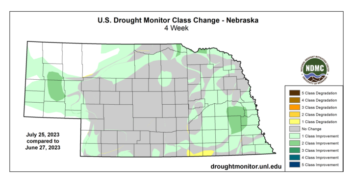
In contrast to July of 2022, which was generally dry and warm statewide conditions that led to expansion and intensification of drought, July 2023 was generally wet and seasonally cool. This led to improvements in drought classification for many areas of the state, with parts of east-central Nebraska showing a two-category improvement during the month.
Unfortunately, with the increased precipitation came some unwelcome guests in the form of damaging hailstorms. Many areas of the state had hail at some point or another during the month of July, but the two worst storms occurred about 48 hours apart in vastly different parts of the state. The first occurred in Scotts Bluff County on July 8 and wiped out several fields of corn, sugarbeets and dry beans. Then, two days later, hail caused almost complete devastation of crops, particularly corn, in the area between Waco and Utica. For some farmers, this was two years in a row of being wiped out by hail.
While wetter and cooler temperatures were quite welcome in the eastern portion of the state, this was less welcome in western Nebraska, where wheat harvest progressed along at the slowest pace in many years.
Precipitation
The upper air pattern that had prevailed for much of the spring and early summer broke down in late June, when a large upper level ridge formed over Texas. This opened the state to more favorable dynamics for thunderstorms, with the first week of July being particularly active. Thereafter, precipitation generally remained a consistent theme, with most places having no extended stretches without measurable precipitation. Precipitation was generally above average across the state, with the north-central, east-central and southeast climate divisions respectively reporting their 10th, seventh, and 10th wettest July's on record. The southwest and south-central climate divisions came in slightly below average.

Below are the unofficial precipitation numbers and departures from the 1991-2020 average by climate division.
- Panhandle, 3.00 inches (+0.69 inch)
- North-central, 5.34 inches (+2.34 inches, 10th wettest)
- Southwest, 2.82 inches (-0.09 inch)
- Central, 4.08 inches (+0.91 inch)
- South-central, 2.99 inches (-0.28 inch)
- Northeast, 4.99 inches(+1.78 inches)
- East-central, 6.35 inches (+2.93 inches, seventhwettest)
- Southeast, 6.07 inches (+2.37 inches, 10th wettest)
Of the CocoRaHS observers who reported 31/31 days in July, most reported over four inches. There was a range of 0.82 inch at Enders 9.16 S to 10.73 inches at Panama 1.3 SE, with over half of that at Panama 1.3 SE coming on July 29.
Temperature
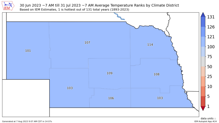
After a fairly warm late spring and early summer, most of July featured cooler northwest flow and a lower number of days with temperatures in the 90s than in recent years. Temperatures were generally on the cool side for July, with most locations in the state finishing the month at least 2.0°F below the 1991-2020 averages. It was the coolest July statewide since 2014 and came in 26th coolest overall out of 131 years. No district had a top-10 cool July, however.

The ridge that plagued Texas and the southwest did shift to the north and east for a brief period in late July. During this stretch, almost all locations managed highs at least in the mid-90s, with upper 90s and low 100s common. In eastern Nebraska, this heat was also coupled with very high dewpoints, leading to afternoon heat index values that easily exceeded advisory criteria and, in some cases, flirted with the 120s. Thankfully, the heat was short-lived for most of the state, with only portions of southwestern and far south-central Nebraska seeing temperatures above 90 in the month's last days. Below are the unofficial temperature numbers and departures from the 1991-2020 average by climate division.
- Panhandle, 70.8°F (-1.9°F)
- North-central, 72.3°F (-2.2°F)
- Southwest, 73.7°F (-2.0°F)
- Central, 73.2 F°(-2.5°F)
- South-central, 74.6°F (-2.5°F)
- Northeast, 72.5°F (-2.8°F)
- East-central, 73.9°F (-2.6°F)
- Southeast, 75.4°F (-2.1°F)
Agricultural Update
Going into July, pastures were improving in the western part of Nebraska but were generally in poor or very poor shape in eastern Nebraska. The percentage of corn and soybean in poor to very poor condition was not historically high but was considerably higher than average. Winter wheat harvest was getting a slow start due to wetter conditions in the Panhandle and southwest.

With cooler and wetter conditions than average prevailing over most of the state in July, the rating on pasture conditions improved from 40% good-excellent/22% poor-very poor, to 54% good-excellent/15% poor-very poor between the July 3 and July 31 NASS crop progress reports. Much of this change was from pasture improvements in eastern Nebraska.
The corn and soybean crop ratings remained steady throughout the month, with corn declining a bit on the July 31 crop progress report. This was likely due to poor dryland crops in parts of central and east-central Nebraska showing more stress after consecutive days of extreme heat.
The downside to a wetter, cooler July was a slower winter wheat harvest than in recent years with the percent of wheat harvest in late July running 14 percentage points behind the five-year average for that time period.
July Mesonet Extremes
- Highest Air Temperature: 107°F, Guide Rock 3E (July 28)
- Lowest Air Temperature: 44°F, Whitman 5 NE (July 6)
- Highest Heat Index Temperature: 124°F, Eagle 3NW (July 28)
- Lowest Wind Chill Temperature: 43°F, Alliance 6NW (July 7)
- Maximum Wind Gust (three meters): 60 mph, Smithfield 2NE (July 11)
- Maximum Wind Gust (10 meters): 59 mph, Wilber 1W (July 29)
- Highest Daily Precipitation: 3.92 inches, Leigh 1W (July 2)
- Highest Four-Inch Soil Temperature: 106°F Lincoln, 1500 N 45th (July 28)
- Lowest Four-Inch Soil Temperature: 57°F, Fordyce 4 W (July 8)
