Highlights
The National Center for Environmental Information (NCEI) preliminary statewide rankings indicate that Nebraska experienced the 71th warmest and 57th wettest February since records began in 1895. NCEI indicates that this winter ranks as the fifth wettest on record with a statewide value of 3.13 inches of liquid equivalent moisture, which is 1.37 inches above the current normal comparison period (1991-2020). Average temperatures for this past winter were ranked the 74th warmest since 1895 with a state average of 24.7°F, which is equal to the normal winter average temperature.
There was a significant reduction in storm activity during February across the state as the atmospheric river events across the west coast were nonexistent. However, the upper air troughs positioned off the west coast that produced these atmospheric river events shifted eastward, with a mean position over the Great Basin region. Energy ejecting out of this mean trough consistently moved across the southern High Plains and southeastern United States. This pattern resulted in much drier conditions across the northwestern half of the state but led to a more active and snowier month across east-central, south-central and southeast Nebraska.
Precipitation
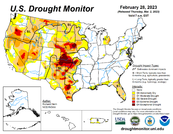
The statewide precipitation value for February 2023 is 0.62 inches according to NCEI, which is 0.04 inches below normal according to the current comparison period. The U.S. Drought Monitor (USDM) depiction of conditions as of Feb. 28 indicates that moderate to extreme drought still prevails across Nebraska. It should be noted that long-term (hydrological) dryness indicators are the dominant concern presently, as short-term indicators (three months or less) have improved due to our wet winter across much of the state.
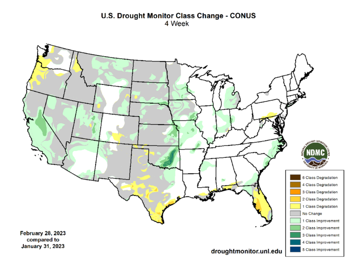
If one compares the change in drought classes during the month of February, there was a one category improvement across parts of extreme north-central and northeast Nebraska. Additionally, small pockets of west-central Nebraska improved one category, while the extreme southeastern corner of Richardson County had a two-category improvement. Falls City 4 NE reported 3.66 inches of moisture during February, making it the wettest cooperative observer location in the state that reports in real time. This location also reported the greatest 24-hour precipitation total during the month with 1.60 inches on Feb. 27.
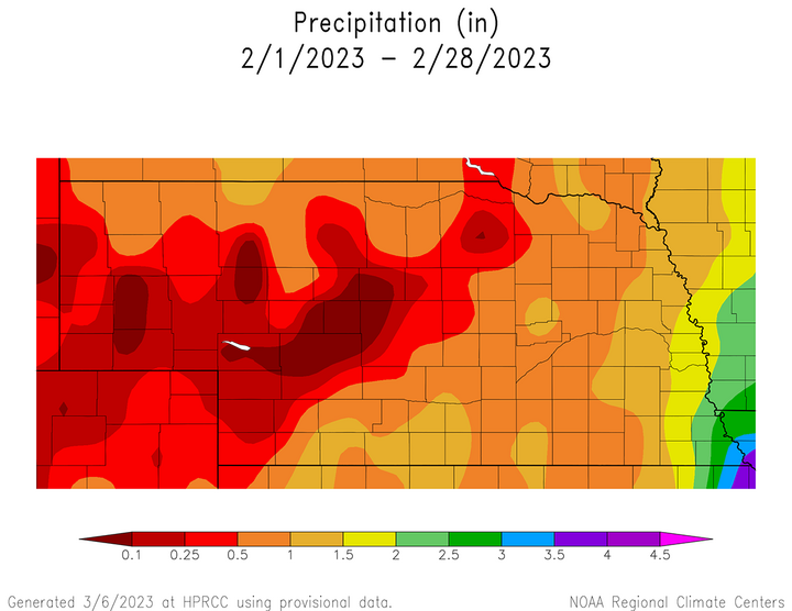
There were four distinct periods where precipitation was recorded across the state: Feb. 9 (southeast corner), Feb. 14-Feb. 16 (southeast half of Nebraska), Feb. 22-24 (entire state), Feb. 27 (southeastern third of Nebraska). On Feb. 9, the southeastern half of Richardson County received 0.25-1.00 inches of moisture, with 1.36 inches recorded at Falls City 5.5 NE. A strong storm system Feb. 14-16 dropped 0.25-0.75 inches of liquid equivalent moisture to the southeastern third of the state, which included a band of 6-11 inches of snowfall along and south of the I-80 corridor between Seward and Omaha. A strong cold front crossed the state Feb. 22-24 dropping two- to six-inch snowfall totals across western Nebraska, with one to three inches common across the east. Finally, another storm system passing south of the state Feb. 27 brought 0.25-0.75 inches of rainfall to the southeastern third of the state.
The cumulative impacts of these storm systems produced monthly precipitation totals between 0.50 and 2.00 inches across the southeastern half of the state, except for Richardson County where precipitation exceeded three inches near the Missouri border. Less than 0.25 inches of moisture was reported across the southern Panhandle, the southwestern Sandhill region, as well as parts of west-central and the northwestern fourth of southwest Nebraska. The northern Panhandle and northern Sandhill region reported 0.25 to 0.50 inches of moisture.
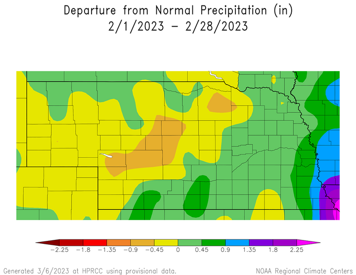
The most concentrated area of above-normal moisture during the month occurred across the southeastern third of Nebraska where surplus moisture approached one inch in the extreme southeastern corner of the state. Areas with the greatest precipitation deficits during the month occurred from west-central Nebraska northeast into the southern Sandhill region. This same region was hit with 18-24 inches of snow during the Jan. 18-19 event.
The greatest 24-hour snowfall total reported by the cooperative weather observation network was 8.8 inches at the Lincoln Airport on Feb. 16. A new daily snowfall record was established and it replaced the old record of 4.0 inches set in 1939. It should be noted that several NERain observers on the south side of Lincoln reported 10 inches of snowfall with this same event. Minden reported the greatest monthly snowfall accumulation during February with 11.5 inches. Springview 2 NW ha reported 64.5 inches of snowfall for the season at the end of February and preliminary data indicates at least 11 cooperative weather observers have reported seasonal totals exceeding 50 inches across northern tier of Nebraska counties.
Temperature
Nebraska’s average temperature for February 2023 was 27.0°F, which is 0.3°F above normal and NCEI ranks it as the 71st warmest since records began in 1895. Preliminary analysis of weather records submitted by NWS cooperative weather observers indicates that a preliminary state high temperature of 67°F was recorded at Falls City Brenner Air Field on Feb. 6 and a state low temperature of -34°F was reported at Harrison 9 NE the morning of Feb. 24.
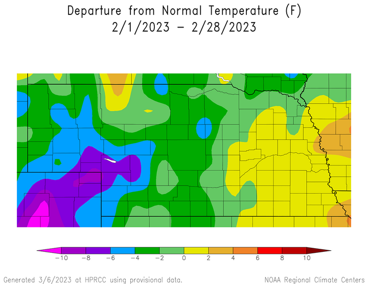
The deep snowpack across northern and western Nebraska slowly eroded during February due to a combination of higher solar radiation reaching the surface and the lack of snow activity. The pace of snowmelt was also influenced by below-normal temperatures across the western two-thirds of the state. Average temperatures for the month were 4-8°F below normal in an area encompassing the southern Panhandle, west-central and the western half of southwest Nebraska. Average temperatures were normal to 4°F below normal across the northern Panhandle and the central third of the state from the Kansas border to the South Dakota border. Average temperatures for eastern Nebraska were normal to 2°F above normal during February.
An examination of NWS field office records during February indicates that the only temperature record set at NWS locations during the month occurred at Hastings, Nebraska. A low high temperature of 13°F was observed on Feb. 23, which tied the record set in 1993, 1960 and 1914. This record cold daily high temperature came in the wake of a significant snow event that blanketed the southeastern third of the state with 4-12 inches of snowfall. This brief period of Arctic air resulted in average temperatures dropping 20-40°F below normal across the western half of the state Feb. 22-26 and 10-25°F below normal across eastern Nebraska Feb. 23-26.
Outlook
The Climate Prediction Center released their official March climate outlooks on Feb. 28, which calls for below-normal temperatures across the entire state of Nebraska. CPC indicates that the southern half of the state has been assigned a slight chance for below-normal temperatures, with a moderate risk across the northern half of Nebraska. CPC also indicates that there is a slight chance for above-normal moisture across the Panhandle, north-central, northeast and the extreme southeast corner of Nebraska. The remainder of the state has been assigned equal chances of receiving above-normal, normal or below-normal temperatures.
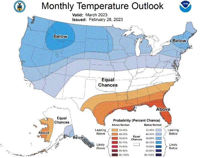
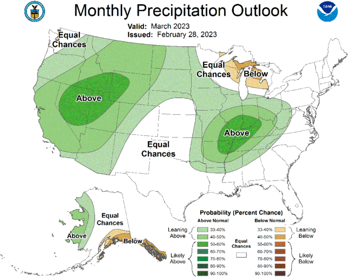
On a national scale, CPC projects below-normal temperatures across the western third of the continental United States and the northern half of country east of the Rocky Mountains. The highest probability of occurrence is assigned to the northern Rocky Mountain region. Above-normal temperatures are forecast from the southeastern half of Texas east-northeast through the southeastern corner of North Carolina. Above-normal precipitation is forecast for the western third of the United States, the northern High Plains region, along with the lower Ohio and mid-Mississippi river valleys. Below-normal moisture is forecast for the Minnesota Arrowhead region, northeast Wisconsin, as well as the entire upper and the northern two-thirds of the lower peninsula of Michigan.
Agricultural Update
Although precipitation events during February were less numerous than December and January, sufficient precipitation fell across the southeastern half of the state during the month to improve statewide top and subsoil moisture estimates. Nebraska Agricultural Statistics Service (NASS) indicates that as of Feb. 26, topsoil moisture was estimated to be 13% very short, 35% short, 44% adequate and 8% surplus. Compared to the last estimate of topsoil moisture conditions on Jan. 28, there was a 4-percentage point improvement in the very short category, a 2-percentage point improvement in short category, an 18-point improvement in the adequate category and a 7-percentage point improvement in the surplus category.
Subsoil moisture estimates also experienced improvement according to NASS, but at a more subdued pace. According to NASS, subsoil moisture estimates on Feb. 26 stood at 30% very short, 43% short, 26% adequate and 1% surplus. Compared to conditions on Jan. 28, the very short category improved 4 percentage points, the short category improved 3 percentage points, the adequate category improved 6 percentage points and the surplus category deteriorated 1 percentage point.
Nebraska’s winter wheat crop showed a very slight improvement when compared to conditions on Jan. 28. As of Feb. 26, NASS rates the winter wheat crop as 11% very poor, 29% poor, 41% fair, 18% good and 1% excellent. When comparing current condition estimates to a month ago, there was a 3-percentage point improvement in the very poor, poor and fair categories. There was a 2-percentage point deterioration in the good category and a 1-percentage point deterioration in the excellent category. Based upon February precipitation totals, wheat crop rating improvement were likely across south-central and southeast Nebraska, while the southern Panhandle and west-central Nebraska likely experienced deterioration where precipitation was less than a quarter inch of liquid equivalent moisture during the month.
February Mesonet Extremes
- Highest Air Temperature: 66.2°F Rulo 5 SW (Feb. 6)
- Lowest Air Temperature: -22.5°F Scottsbluff 2 NW (Feb. 23)
- Highest Heat Index Temperature: 65.4°F Rulo 5 SW (Feb. 6)
- Lowest Wind Chill Index Temperature: -40.3°F Scottsbluff 2 NW (Feb. 23)
- Maximum Wind Gust (9 feet): 55.4 mph Long Pine 20 S (Feb. 15)
- Highest Daily Precipitation: 1.08 inches Rulo 5 SW (Feb. 28)
- Highest Four-Inch Soil Temperature: 50.3 F Lincoln 1500 N 45th (Feb. 27)
- Lowest Four-Inch Soil Temperature: 10.1 F Arthur 8 S (Feb. 23)
