Highlights
The aggressive storm activity that developed in December continued through the month of January. The National Center for Environmental Information (NCEI) preliminary statewide rankings indicate that Nebraska experienced the 56th warmest and third wettest January since records began in 1895. NCEI indicates that first two months of winter are the fifth wettest on record with a statewide value of 2.34 inches of liquid equivalent moisture, which is 1.24 inches above normal based upon the current 1991-2020 comparison period.
The stormy pattern that developed across the state during December continued into January across Nebraska. Significant snowfall was reported for a second consecutive month across the Panhandle, north-central and northeast Nebraska. The impact of these storms resulted in a one category improvement to a small area of the eastern Niobrara river valley, while the remainder of the state remained unchanged during January. If the wet trend across Nebraska since the beginning of winter continues into the early spring, the U.S. Drought Monitor should begin to reflect long-term drought conditions (hydrological) instead of both short (agricultural) and long-term impacts.
Precipitation
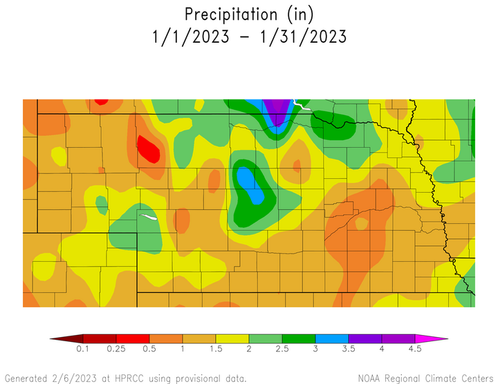
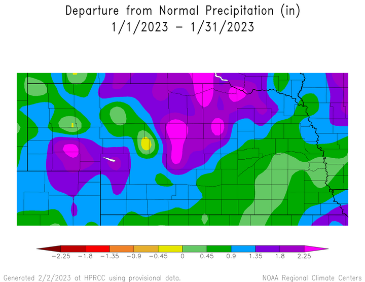
The average statewide precipitation value for January 2023 is 1.37 inches according to NCEI, which is 0.87 inches above normal based on the current 1991-2020 baseline comparison period. Liquid precipitation totals for the month exceeded 1.50 inches across the northwestern two-thirds of the state and between 1.00 and 1.50 inches across the southeastern one-third of Nebraska. Liquid equivalent precipitation exceeded three inches across parts of the eastern Niobrara river valley and the south-central Sandhill region. The entire state experienced above-normal precipitation during January and the last time widespread above-normal precipitation was reported across Nebraska in January was 2017. Surplus moisture across the southeastern third of the state ranged from 0.25 to 0.90 inches, compared to 0.90 to 2.25 inches for the northwestern two-thirds of the state.
For a second consecutive month, snowfall activity was widespread and heavy across the northwestern two-thirds of the state. There were six systems that crossed the state and produced measurable snowfall: Jan. 1-3, Jan. 11, Jan. 17-19, Jan. 20-22, Jan. 26-27 and Jan. 29-20. Six to 12 inches of snow was reported from McCook northeast to Yankton Jan. 1-2, 1-3 inches Jan. 11 across the southern Panhandle and parts of southwest Nebraska, 12-18 inches from the southern Panhandle through the northeastern Sandhill region January 17-19, 3-6 inches south of a line from Red Cloud to Nebraska City Jan. 21-22, 4-8 inches across northeast Nebraska Jan. 26-27 and 2-4 inches west of a line from Wayne to Holdrege Jan. 29-30.
Peak snowfall totals reported from these storm systems, which are based on real-time reporting from National Weather Service cooperative and NeRain observers, indicate 13.3 inches fell at Anselmo 9.2 NW during the Jan. 1-2 snow event. Over 20 inches of snow were reported in the Custer county area from the Jan. 17-19 event and two NeRain observers reported at least 25 inches: Callaway 0.2 S (26.5 inches) and Anselmo 11.8 WSW (25.0 inches). Well over half of the cooperative observers don’t report in real time and it is possible that more locations in the central Sandhill region exceeded 20 inches during the mid-January event.
Numerous snowfall and liquid equivalent precipitation records were set during January at National Weather Service offices across the state, with Jan. 18 being the most prevalent date. Snowfall records set on Jan. 18 include Grand Island (10.0 inches), Hastings (10.8 inches), North Platte (13.9 inches) and Valentine (7.0 inches). Liquid equivalent precipitation records set Jan. 18 include Grand Island (0.97 inches), Hastings (0.93 inches), Lincoln (0.82 inches), Norfolk (0.51 inches), North Platte (1.03 inches), Omaha (0.52 inches) and Valentine (0.75 inches). The greatest 24-hour liquid equivalent precipitation reported from real time observations during the month of January occurred at Anselmo 2 WSW with 1.84 inches on Jan. 19.
Preliminary NWS cooperative snowfall totals from real-time observers indicate that 36.0 inches of snowfall were received at Anselmo 2 WSW and Springview 2 NW during the month of January. It is likely that several more locations within the Sandhill region will exceed 30 inches for the month when paper submitted observations are entered into the national climate data base. At least five cooperative observer locations had exceeded 50 inches of snowfall for the season by the end of January: Bloomfield (53.3 inches), Chadron (54.2 inches), Lodgepole 8 N (53.6 inches), Springview (55.5 inches) and Valentine (52.7 inches). If normal snowfall occurs for the remainder 2022-23 snow season, all five of these locations will fall in the top three snowiest seasons on record.
Temperature
Nebraska’s average temperature for January 2022 was below normal and preliminary rankings by NCEI ranks it as the 56th warmest since records began in 1895. NCEI indicates the January statewide average temperature was 24.8°F, which is 2.7°F above the comparison period of 1991-2020. Preliminary analysis of weather records submitted by cooperative weather observers shows a state high temperature of 59°F was reported at Superior on Jan. 10 and a state low temperature of -25°F reported at Verdel 6 SSE on Jan. 31.
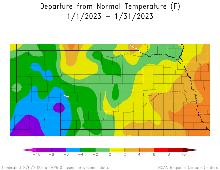
An extensive snowpack that began to build during December and continued to increase through the first three weeks of January contributed to below-normal temperatures across the Panhandle, southwest and west-central Nebraska. Average temperatures across this region ranged from 2-8°F below normal. Average temperatures were normal to 2°F below normal across central, northeast and the eastern half of north-central Nebraska. This region lost much of December’s snowfall during a warm stretch prior to the Jan. 17-19 storm event, which offset the impacts of a deep snowpack and Arctic air which dominated the last 10 days of the month. Average temperatures across the eastern third of Nebraska were normal to 2°F above normal. The primary precipitation mode in this region was rain and sleet instead of snowfall, which allowed for more surface heating as compared to western Nebraska, where snow cover remained in place for a majority of the month.
Outlook
The Climate Prediction Center released their official February climate outlooks on Jan. 31, which calls for equal chances of above-normal, normal, or below-normal precipitation across the entire state of Nebraska. CPC indicates that there is a slight chance for below-normal temperatures across the Nebraska Panhandle, while the remainder of the state has equal chances for above-normal, normal, or below-normal temperatures.
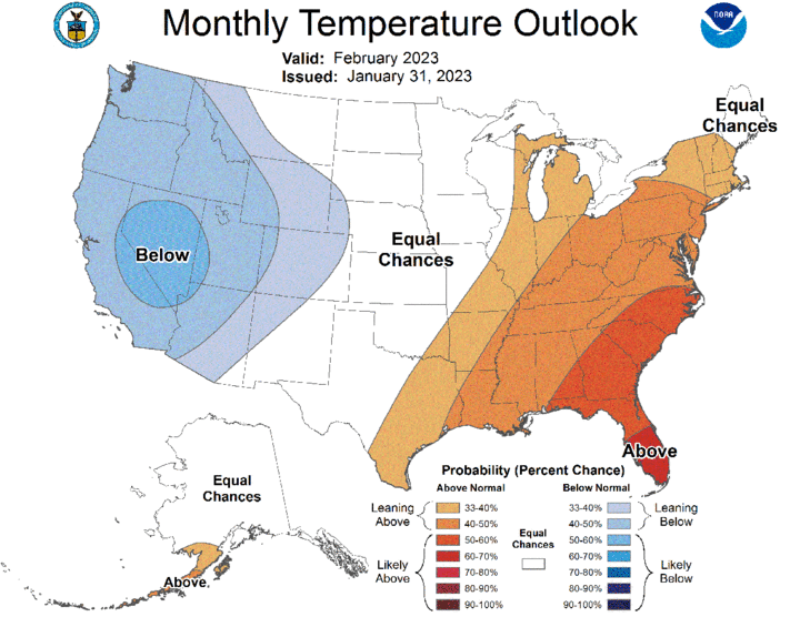
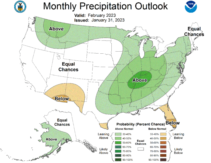
On a national scale, CPC projects below-normal temperatures across the western third of the continental United States and above-normal temperatures across the eastern third of the country. CPC indicates equal chances of above-normal, normal, or below-normal temperatures for the central third of the U.S. Above-normal precipitation is forecast for the northern Rockies eastward through the Great Lakes, along with the Ohio River valley southward through the southern Mississippi River valley. Below-normal precipitation is forecast for a small area of the southwest, which includes the southeastern half of Arizona and the southern half of New Mexico.
Agricultural Update
With six snow-producing systems impacting the state during January, snow depths across the state at the end of January ranged from 1-2 inches across the southeastern corner of the state to over two feet in the central Sandhills. The deep snowpack made grazing difficult for cattle and supplemental feeding increased across the northwestern half of Nebraska. Additionally, the intrusion of Arctic air at the end of the month increased frost depths to 20 inches across parts of northeast Nebraska and up to six inches south of the I-80 corridor. Significant ice accumulations on rivers were being reported on the Elkhorn, Niobrara, Loup and portions of the Platte watershed, which elevates concern for lowland flooding if snowmelt is coupled with air temperatures breaching the 60°F mark.
The Nebraska Agricultural Statistics Service (NASS) monthly crop progress report indicated that the condition of the wheat crop improved at the beginning of January due to the snow and rainfall reported with the storm system that impacted the state from Dec. 29-Jan. 2. According to NASS, winter wheat was rated 10% very poor, 26% poor, 46% fair, 16% good and 2% excellent. Winter wheat showed a significant decline in conditions in the NASS report issued on Jan. 31 with 14% of the crop reported as very poor, 26% poor, 38% fair, 20% good and 2% excellent. Minimum temperatures dropping into the -10°F to -20°F at the end of the month, coupled with a lack of significant snow cover caused widespread leaf burning, but it is still unclear whether it was cold enough to kill plant crowns and the full extent of damage will likely not be known until conditions are warm enough to push the crop to break its winter dormancy period.
January Mesonet Extremes
- Highest Air Temperature: 57.1°F Rulo 5 SW (Jan. 16)
- Lowest Air Temperature: -24.8°F Scottsbluff 2 NW (Jan. 31)
- Highest Heat Index Temperature: 56.6°F Rulo 5 SW (Jan. 16)
- Lowest Wind Chill Index Temperature: -35.3°F Alliance 6 NW (Jan. 31)
- Maximum Wind Gust (9 feet): 46.0 mph Long Pine 20 S (Jan. 27)
- Highest Daily Precipitation: 0.71 inches Rulo 5 SW (Jan. 19)
- Highest Four-Inch Soil Temperature: 42.8°F Rulo 5 SW (Jan. 19)
- Lowest Four-Inch Soil Temperature: 14.2°F Alliance 6 NW (Jan. 31)
