Highlights
A series of strong storms moved through the west coast of the United States and helped fuel an active pattern across Nebraska during the first month of climatological winter. The National Center for Environmental Information (NCEI) preliminary statewide rankings indicate that Nebraska experienced the 32nd coldest and 104th wettest December since records began in 1895. With the inclusion of December’s climate information, NCEI ranks 2022 as Nebraska’s fourth driest and 116th warmest in the last 128 years of climatological records.
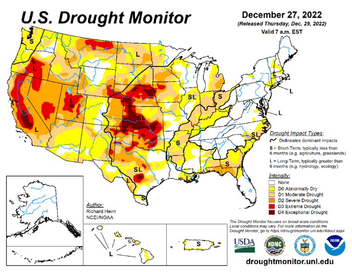
Although December did bring significant snowfall to the northwestern half of Nebraska, there was only limited improvement (one category) in drought conditions across extreme northwest and north-central Nebraska, along with portions of west-central and southwest Nebraska. This is because drought conditions have been the dominate climate driver over the past two to three years (location dependent) and longterm precipitation deficits remain significant.
Precipitation
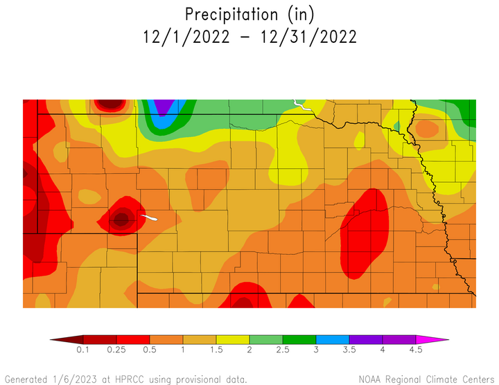
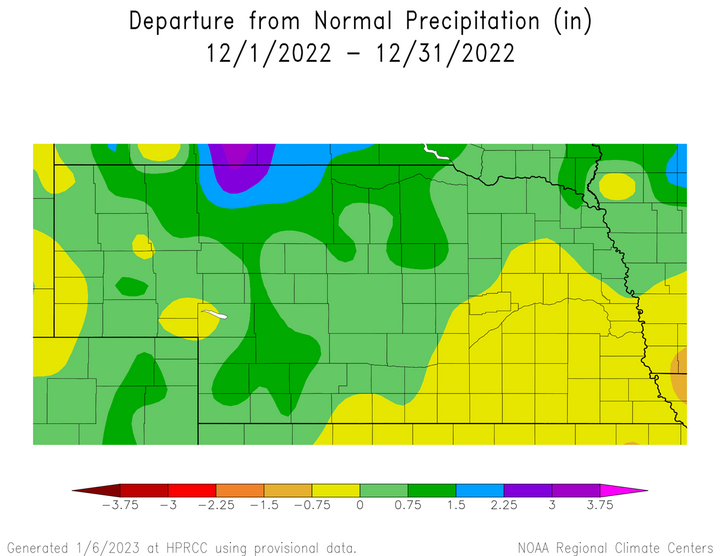
The average statewide precipitation value for December 2022 was 0.95 inches according to NCEI, which is 0.35 inches above average based upon the current 1991-2021 comparison period. Liquid precipitation totals for the month were greatest along the Nebraska–South Dakota border from the northeastern corner of the Panhandle eastward through the central Niobrara river valley. A band of 1.00-1.50 inches of liquid equivalent moisture fell from southwest through northeast Nebraska and along the Missouri river from Yankton, South Dakota to Omaha, Nebraska.
The southern half of the Panhandle, south-central, central, east-central and southeast Nebraska reported between 0.50 and 1.00 inches of liquid equivalent moisture. Within this broad area of the state, precipitation totals dropped to 0.25-0.50 inches of liquid equivalent moisture along the Wyoming–Nebraska border, as well as a pocket of east-central and south-central from Norfolk southward to Geneva. The North Platte Airport set a daily rainfall record of 0.73 inches on Dec. 29, which eclipsed the old record of 0.68 inches set in 1906 and 2006.
The vast majority of precipitation during December fell in the form of snow across northern and western Nebraska and monthly totals ranged from 10 to 35 inches. Across the southeastern third of the state, the majority of precipitation received came in the form of rain, sleet and/or freezing drizzle and snowfall totals ranged from 1-5 inches. There were five distinct snow events during the month: Dec. 8–10 (northern border), Dec. 13–16 (northern, western), Dec. 19–20 (southeast), Dec. 22–24 (entire state), Dec. 29–30 (northern, western). Blizzard conditions developed across northern and western Nebraska during the Dec. 13–16 storm event, with near blizzard conditions reported with the Dec. 22–24 and Dec. 29–30 events.
Preliminary analysis of stations reporting in real time indicates that Chadron 3 SW received 34.6 inches of snow during the month, while the Valentine Airport logged 22.3 inches. For comparison, during the 2021-22 snow season Chadron 3 SW received 38.0 inches of snow, while the Valentine Airport recorded 18.0 inches. The Valentine Airport set two daily snowfall records with 7.0 inches on Dec. 9 and 10.3 inches on Dec. 14. The Scottsbluff Airport recorded a daily record snow depth of 10 inches on Dec. 13.
Temperature
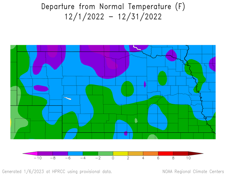
Average temperatures were below normal statewide and preliminary data indicates this was the 32nd coldest December since records began in 1895. NCEI indicates that the December statewide average temperature was 22.9*F, which is 2.4*F below the comparison period of 1991-2020. Preliminary analysis of weather records submitted by cooperative weather observers indicates a high temperature of 69*F was reported at Trenton Dam on Dec. 28, with -26*F recorded as the state’s low temperature set at Harrison on Dec. 22.
Although above normal temperatures were common statewide at the beginning and end of December, the mid-month blizzard event brought an extended period of Arctic air and below normal temperatures Dec. 14–26. The Arctic air intrusion was most intense between Dec. 18 and Dec. 24 of the month when average temperature anomalies ranged from 20*F to 40*F below normal. For the month, the northern half of Nebraska averaged 4-10*F below normal, while most locations across the southern half of the state were 2-4*F below normal.
Outlook
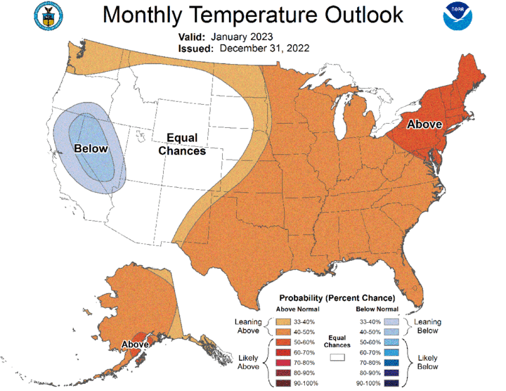
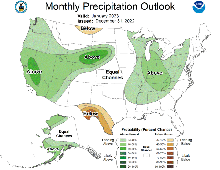
The Climate Prediction Center (CPC) issued their final January temperature and precipitation outlook on Dec. 31, 2002. CPC’s temperature outlook tilts toward above-normal temperatures across the eastern half of Nebraska, with the highest odds assigned to areas east of a line from Geneva to West Point. The western half of state has equal chances of seeing above-normal, normal, or below-normal temperatures. CPC’s precipitation outlook forecasts above-normal precipitation for the northwestern half of Nebraska, with a high probability assigned to the Panhandle and northwestern Sandhill region. The high probability of above-normal moisture was the result of the outlook being issued 24 hours prior to the arrival of a strong storm system that crossed the state during the first two days of 2023. The southeastern half of Nebraska has been assigned equal chances of abov-normal, normal, or below-normal moisture.
Agricultural Update
The aggressive snow pattern across northern and western Nebraska led to increased costs for cattle producers because of limited grazing opportunities due to deep snow cover. Drought conditions this year led to below-normal hay production and a continuation of December conditions for the remainder of this winter will likely lead to hay shortages. Producers may be faced with the difficult position of buying expensive hay to supplement feeding or culling herds due to low forage stockpiles.
Although the moisture that fell in December was welcome following a very dry fall, locations across the northern half of the state likely experienced minimal soil moisture recharge due to frozen top soils. Prior to the onset of Arctic air, frost depths across the northern third of the state ranged from 6-10 inches. Frost depths had increased to 12-15 inches immediately after the Christmas holiday weekend. Therefore, much of the moisture received during December likely ran off when temperatures warmed above freezing, but it should benefit streamflows and low stock ponds.
December Mesonet Extremes
- Highest Air Temperature: 70.2 F Indianola 8 SW (Dec. 27)
- Lowest Air Temperature: -25.3 F Whitman 5 NE (Dec. 22)
- Highest Heat Index Temperature: 69.1 F Bushnell 12 SE (Dec. 27)
- Lowest Wind Chill Index Temperature: -57.2 F Bushnell 12 SE (Dec. 22)
- Maximum Wind Gust (9 feet): 54.8 mph Bushnell 12 SE (Dec. 22)
- Highest Daily Precipitation: 0.89 inches Merna 2 SW (Dec. 13)
- Highest 4-Inch Soil Temperature: 53.0 Lincoln 1500 N 45th (Dec. 2)
- Lowest 4-Inch Soil Temperature: -6.1 F Arthur 8 S (Dec. 22)
