Weather Review
An upper air trough moved across the northern Plains Aug. 26-27, which briefly ushered cooler air across the state Aug. 28. Weather models indicated this trough would deepen over the northern Plains and pull below-normal temperatures into the state Aug. 28-29. In reality, this trough didn’t deepen until it reached eastern Minnesota and the brunt of cooler air stayed northeast of the state.
The western U.S. upper air ridge quickly shifted eastward and high temperatures across the western third of the state reached the upper 90s to low 100s Aug. 30–Sept. 2. It took a couple of days for the ridge to build into eastern Nebraska before high temperatures moved into the lower 90s. A quick-moving upper air trough began to cross the northern Plains Sept. 1 and drove a cold front through Nebraska the afternoon of Sept. 1 through the evening of Sept. 2. High temperatures across the western third of the state dropped into the upper 80s to low 90s Sept. 2-3, while eastern Nebraska high temperatures failed to breach the 90°F mark until Sept. 5.
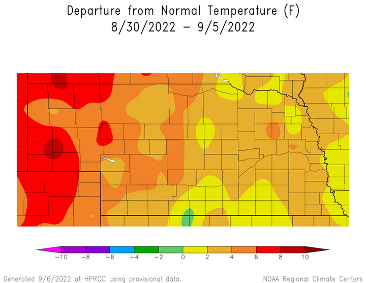
Western Nebraska was on the eastern edge of the western U.S. upper air ridge that brought widespread 100-110°F readings to the southern two-thirds of the Great Basin and west coast region. This air mass was exceptionally dry with dew point temperatures consistently under 40°F, which allowed the air mass to heat up quickly under sunny skies. By the same token, this area consistently reported low temperature that ranged from the low 40s to low 50s last week. Figure 1 indicates that even with diurnal temperature swings in excess of 40°F, average temperature anomalies last week were 4-8°F above normal across the western half of Nebraska. Further east, average temperature anomalies for the week ranged from normal to 4°F above normal.
The daily maximum temperature extremes for airport locations reported by the National Weather Service (NWS) are as follows: Aug. 29 — 91°F (Broken Bow, North Platte, Ord), Aug. 30 — 98°F (Chadron, Scottsbluff), Aug. 31 — 99°F (Lexington, McCook, Ord), Sept. 1 — 100°F (Chadron), Sept. 2 — 102°F (McCook), Sept. 3 — 93°F (Chadron), Sept. 4 — 101°F (Chadron, Scottsbluff).
The daily minimum temperature extremes for airport locations reported by the NWS are as follows: Aug. 29 — 44°F (Gordon), Aug. 30 — 52°F (Tekamah), Aug. 31 — 46°F (Alliance), Sept. 1 — 52°F (Kimball), Sept. 2 — 44°F (Gordon), Sept. 3 — 41°F (Ord), Sept. 4 — 46°F (Ord).
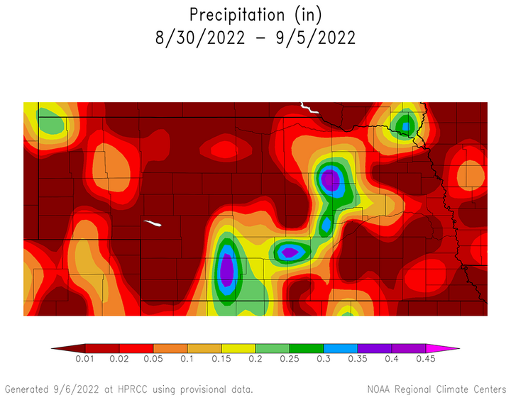
Although there was a scattering of precipitation across the state this past week, the only widespread moisture that occurred was with the surface cold front the moved through the state Sept. 1-2. The most concentrated areas of precipitation associated with this front occurred across north-central, northeast, central and south-central Nebraska (Figure 2). Even in these areas, many locations reported less than 0.10 inches of moisture. Outside of this event, the remainder of precipitation reported across the state occurred primarily across extreme northern and eastern Nebraska as energy rotated around the periphery of the high-pressure ridge that slowly built eastward during the middle of last week.
The daily maximum precipitation values reported from NERain observers are as follows: Aug. 29 — 0.59 inches (Bennington 0.1 ESE, Fort Calhoun 2.9 SSW), Aug. 30 — 0.23 inches (Minden 0.4 ESE), Aug. 31 — 0.57 inches (Rushville 7.0 SSW), Sept. 1 — 0.80 inches (Spalding 6.2 NE), Sept. 2 — 0.17 inches (Chester 3.4 NE), Sept. 3 — 0.51 inches (Cambridge 7.3 N), Sept. 4 — 0.00 inches (all stations).
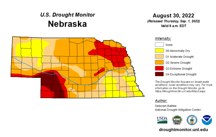
The dryness across eastern Nebraska has finally been recognized by the U.S. Drought Monitor authors, leading to an expansion of D1 (moderate drought conditions) into parts of east-central and southeast Nebraska (Figure 3). This area could have seen expansion several weeks ago based upon precipitation metrics alone, but some of the indicators used to classify drought intensity fell shy of moderate drought status. That is no longer the case and further expansion of D1 is possible across the southeast based upon meager precipitation and above-normal temperatures received last week.
Crop Progress
The first state crop report of this meteorological fall for conditions ending on Sept. 4 was issued on Sept. 6 due to the federal holiday on Monday. Once again, widespread above-normal temperatures and widely scattered pockets of precipitation dominated this past week. Surprisingly, crop condition ratings and soil moisture estimates were close to steady when compared to the Nebraska Agricultural Statistics Service (NASS) crop report for conditions as of Aug. 28.
Of the three major warm-season grain crops grown in Nebraska, soybeans rated good to excellent dropped two percentage points to 41% from the Aug. 28 estimate. Sorghum and corn remained unchanged from the previous week with the good to excellent ratings estimated to be 20% and 39%, respectively. There were subtle shifts, however, regarding the two lowest condition classifications — poor and very poor. Soybeans and sorghum rated poor to very poor increased two percentage points this week to 41% and 62%, respectively. Corn rated poor to very poor decreased one percentage point to 33%.
NASS estimates that 74% of the corn crop has reached the dent stage as of Sept. 4, which compares to 76% last year and the five-year average of 73%. Nineteen percent of the crop is estimated to be mature, which compares to 17% last year and the five-year average of 13%. There have been scattered reports of harvest activity, but not enough to be statistically relevant (less than 1% harvested).
Like corn, there have been scattered reports of soybeans harvested across east-central and southeast Nebraska, but not enough acreage to be statistically relevant. NASS estimates that 25% of the crop is dropping leaves, which is ahead of last year’s pace of 19% and the five-year average of 17%. Ninety-five percent of the sorghum crop was headed out on Sept. 4, compared to 100% last year and the five-year average of 99%. NASS estimates coloring at 57%, behind last year’s pace of 78% and the five-year average of 67%. Maturity of the sorghum crop reached 5%, which is equal to last year and one percentage point behind the five-year average.
Pastures and rangeland conditions as of Sept. 3 were rated 50% very poor, 28% poor, 15% fair, 6% good and 1% excellent. Compared to the Aug. 28 estimates, the only changes occurred in the lowest two categories as the "very poor" rating shrank two percentage points and was shifted to the "poor" category, which increased an equal amount. It will likely take several widespread precipitation events, coupled with cooler temperatures, to significantly reduce the amount of area rated poor to very poor.
Although not as strong as previous weeks, topsoil and subsoil moisture estimates declined again when compared to conditions on Aug. 28. NASS currently estimates topsoil moisture at 47% very short, 37% short, 16% adequate and 0% surplus. Subsoil moisture is estimated to be 42% short, 38% short, 20% adequate and 0% surplus. Topsoil rated very short increase one percentage point from the previous week, while topsoil moisture rated short expanded two percentage points. These increases came at the expense of the adequate rating, which dropped three percentage points from the previous week. The only changes in the subsoil moisture condition estimate was a one-percentage point increase in the short rating and a subsequent one-percentage point decline in the fair rating.
Weather Outlook
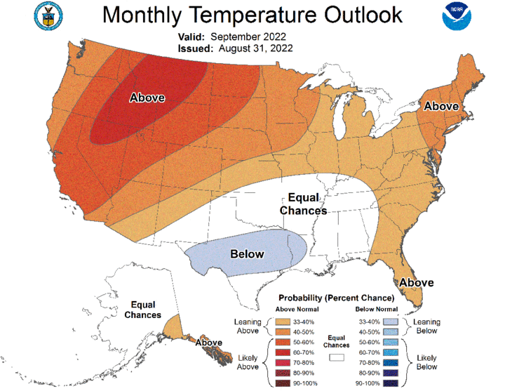
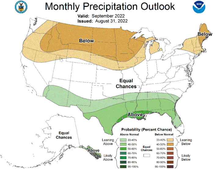
The Climate Prediction Center (CPC) replaced their preliminary September temperature and precipitation outlooks issued Aug. 22 and with their official outlook issued on Aug. 31. Above-normal temperatures are forecast for Nebraska, with the highest probability of occurrence assigned to the northwestern corner of the Panhandle (Figure 4). Below-normal moisture is favored north of a line from Scottsbluff to Red Cloud, with the highest probabilities assigned to areas north of a line from Valentine to Oakland, Nebraska. This area lies on the south periphery of expansive area of below-normal precipitation forecast from the northern Rockies eastward to the northwestern Great Lakes region (Figure 5).
The most current GFS weather model run used in this forecast was issued the morning of Sept. 7 and continues to favor extended periods of dry weather, interspersed with an occasional upper air trough passing through the northern Plains. In short, the forecasted weather pattern looks eerily similar to what has been occurring for the past two months. The only differences are that high temperatures are not forecast to be as warm as recent weeks and precipitation output from the GFS model is slightly more aggressive.
The GFS model indicates that an upper air trough will move through the northern Plains Sept. 8-10 and drive a cold front through the state. Current precipitation forecasts indicate the potential for showers and thunderstorms across the entire state, with high temperatures forecast to drop from the 90s Sept. 6-9 into the 70s Sept. 10-11. Moisture forecast with this system has steadily increased over the past three days and the eastern half of the state is now forecast to receive 0.50-1.25 inches of moisture. Central through northeast Nebraska currently has the highest odds of receiving more than 0.50 inches. Unfortunately, precipitation totals are much lighter for western Nebraska, but do point to the potential for 0.25-0.50 inches of moisture.
After this upper air trough shifts toward the eastern Great Lakes, an upper air ridge will redevelop over the western United States and gradually shift eastward during the first half of next week. A weak upper air trough is forecast to cross the northern Plains Sept. 14-15 and the GFS model hints at the possibility of moisture developing across eastern Nebraska. Current model output would suggest that less than 0.25 inches of moisture is likely. Another weak wave is forecast to move along the ridge periphery on Sept. 17, possibly inducing some scattered shower activity across the eastern third of the state.
High temperatures will slowly warm Sept. 12-14 into the low to middle 80s east and upper 80s to low 90s west. High temperatures will likely cool 5-10°F Sept. 15-17 due to cloud cover associated with the two weak troughs forecast to cross the northern Plains. After these troughs pass east of Nebraska, the GFS model builds a strong upper air trough into the western United States. This pushes the ridge toward the central Plains and a return to warm and dry conditions are forecast Sept. 18-20. High temperatures across the western third of the state are currently forecast to be in the middle to upper 90s, with upper 80s to low 90s forecast for eastern Nebraska.
Energy from this trough is currently forecast to impact the northern Rockies and northern Plains through Sept. 20, then the GFS model attempts to move the upper air trough into the central Plains. If this comes to fruition, high temperatures will drop into upper 60s to middle 70s Sept. 21-23 and be accompanied by widespread precipitation statewide. Confidence is low regarding this trough’s forecasted movement, since the GFS model is notorious for moving deep western U.S. upper air troughs eastward too fast. I would not be surprised to see the GFS model slow the progression of this upper air trough by several days as the predicted event is still 14 days into the future.
