Weather Review
The upper air trough responsible for the passage of a cold front through the state Sept. 9-10 didn’t deepen to the extent models originally forecast, which resulted in a brief (one- to two-day) cool down Sept. 11-12. An upper-level ridge centered over the southern High Plains quickly built northward in response to a strong upper air trough moving into the Pacific Northwest Sept. 12-15. High temperatures quickly warmed back into the 90s statewide, as surface winds turned to the southwest ahead of the slow-moving west coast upper air trough.
Very dry air was in place statewide prior to the upper air trough, ejecting energy eastward. The Alliance Airport reported a 61-degree temperature range on Sept. 12. Air temperatures bottomed out at 31°F before peaking that afternoon at 92°F. Although elevation did play a role in cooling air temperatures below freezing, it was the lack of moisture in the air that allowed air temperatures to warm up so dramatically.

A slow-moving cold front entered northwest Nebraska the evening of Sept. 15 and cleared the southeastern corner during the early morning hours of Sept. 17. Under heavy cloud cover and scattered precipitation, high temperatures across the western two-thirds of the state struggled to break out of the 60s. Eastern Nebraska didn’t cool down as dramatically and high temperatures were consistently in the middle 70s to low 80s Sept. 17-18.
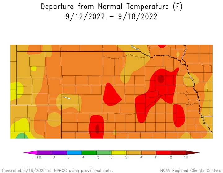
Even with brief cooldowns at the beginning and end of last week, average air temperature anomalies were still above normal (Figure 1). Average temperatures ranged from 4-8°F above normal from the eastern Panhandle to the Missouri River. Within this region, average temperature anomalies of 6-8°F above normal were reported in the McCook and Broken Bow areas, as well as a two county-wide swath from Kearney northeast to Norfolk. The western two-thirds of the Panhandle reported average temperature anomalies 2-4°F above normal, except for a pocket between Kimball and Scottsbluff where anomalies were normal to 2°F above normal.
The daily maximum temperature extremes for airport locations reported by the National Weather Service (NWS) are as follows: Sept. 12 — 93°F (Chadron, Scottsbluff), Sept. 13 — 97°F (McCook), Sept. 14 — 95°F (McCook), Sept. 15 — 91°F (Grand Island, Hebron, Lincoln), Sept. 16 — 90°F (Ogallala), Sept. 17 — 91°F (Beatrice, Fall City, Hebron), Sept. 18 — 94°F (Beatrice).
The daily minimum temperature extremes for airport locations reported by the NWS are as follows: Sept. 12 — 31°F (Alliance), Sept. 13 — 40°F (Alliance), Sept. 14 — 48°F (Gordon), Sept. 15 — 55°F (Kimball), Sept. 16 — 45°F (Kimball), Sept. 17 — 43°F (Kimball), Sept. 18 — 51°F (Alliance).
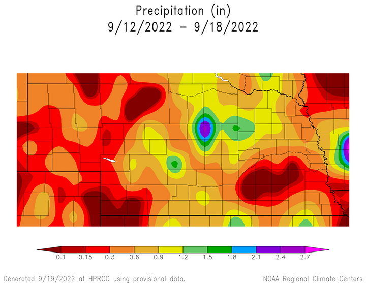
The vast majority of precipitation that was reported by NERain observers last week fell Sept. 15-17 as an upper air trough moved across the Dakotas and pushed a surface cold front through the state. Cumulative rainfall totals for the Sept. 12-18 period were in the 0.50- to 2.50-inch range across south-central, central and the southwest half of northeast Nebraska (Figure 2). On the polar opposite end of the spectrum, less than 0.25 inches of moisture was reported across the northwest Sandhills, the extreme southwest corner of the state and the I-80 corridor from York through Lincoln.


Only about 25% of the NERain observations are included in Figure 2, which is based primarily on National Weather Service cooperative observer data. Thus, there were small pockets of precipitation scattered across the western one-third of the state where NERain observers reported between 0.50 and 0.75 inches of moisture that doesn’t appear in this graphic. Additionally, precipitation exceeded two inches at multiple locations between Kearney and Columbus.
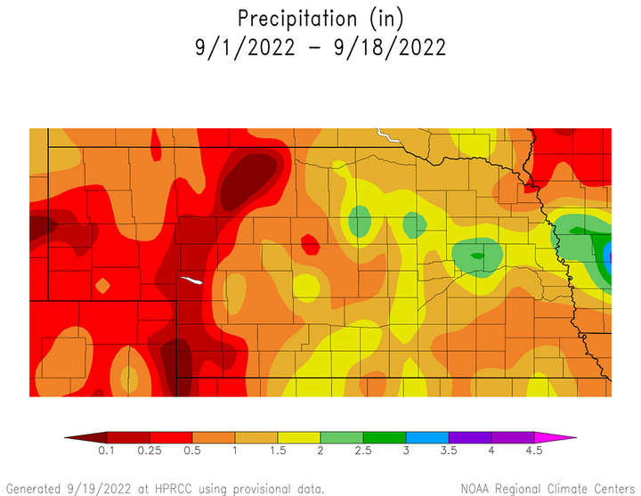
We have now had two consecutive weeks where a west coast upper air trough has pushed eastward through the northern half of the High Plains (ND, SD, NE). Monthly precipitation received through Sept. 18 is presented in Figure 3. Rainfall has exceeded 1.50 inches in parts of central, east-central, northeast and south-central Nebraska. Less than 0.50 inches of moisture has accumulated this month across the western half of southwest Nebraska, as well as the southern half of the Panhandle.
It is important to remember that normal range of precipitation in September varies from 3.00-3.50 inches across the eastern tier of Nebraska counties. These totals drop to 1.75-2.25 inches across central Nebraska, 1.50-1.75 in the North Platte area and down to 1.25 along the Wyoming border in the Panhandle. Therefore, this 1.75-inch spread in normal September precipitation from east to west must be converted into departures from normal moisture in order to accurately compare different areas of the state.
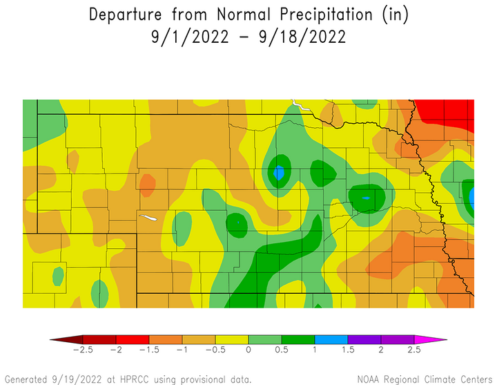
Monthly precipitation anomalies through Sept. 18 are depicted in Figure 4. Positive monthly precipitation anomalies now encompass the northwestern Panhandle, south-central, central and parts of northeast Nebraska. Precipitation deficits exceeding one inch are located across extreme northeast Nebraska, as well as parts of east-central and southeast Nebraska. Southwest Nebraska northward through the western Sandhill region have accumulated precipitation deficits exceeding 0.50 inches.

On a positive note, the most recent precipitation forecast issued by the Weather Prediction Center (NOAA) calls for 0.50-1.25 inches of moisture across the southwest half of the state as the upper level low currently off the coast of California system moves toward Nebraska through the end of this week. If this precipitation verifies, monthly precipitation surplus anomalies would expand westward toward North Platte and McCook. It would take at least two inches of moisture across east-central, southeast and extreme northeast Nebraska to eliminate the precipitation deficits that have accumulated through Sept. 18.
The daily maximum precipitation values reported from NERain observers are as follows: Sept. 12 — 0.20 inches (Davenport 0.1 W), Sept. 12 — 0.00 inches (all stations), Sept. 14 — 0.48 inches (Bertrand 6.1 SE), Sept. 15 — 0.75 inches (Elsie 9.7 SSE), Sept. 16 — 2.28 inches (Ord 9.0 NW), Sept. 17 — 2.06 inches (Richland 3.0 W), Sept. 18 — 0.72 inches (Steinauer 3.3 ENE).
Crop Progress
The vast majority of precipitation reported across the state occurred Sept. 15-17 in response to a cold front that slowly moved southeastward across Nebraska. There was not a strong push of cold air with this front and the slight cool down Sept. 16-17 was influenced by extensive cloud cover. The most concentrated area of moisture fell across central, south-central and east-central Nebraska, where 1-2.50 inches of rainfall was reported by NERain observers. For the remainder of the state, precipitation was more scattered and generally less than a half inch.
Although the heat pushed warm-season crops closer to maturity, precipitation was insufficient on a statewide basis to stem further deterioration to warm-season crops and rangeland conditions.
The state corn crop had the greatest overall crop condition decline during the past week according to the Nebraska Agricultural Statistics Service (NASS). As of Sept. 18, the condition of the corn crop was rated 18% very poor, 18% poor, 27% fair, 29% good and 8% excellent. Compared to Sept. 11 conditions, corn rated good to excellent fell five percentage points. Corn reaching the dent stage was estimated at 93% and maturity at 52%. Corn reaching the dent stage was equal to last year and the five-year average, while corn deemed mature was ahead of last year’s pace of 51% and the five-year average of 46%. The 2022 corn harvest is estimated to be 6% complete, which is equal to last year and ahead of the five-year average of 5%.
Soybean and sorghum condition ratings also declined this past week, just at a slightly slower pace than corn. As of Sept. 18, NASS estimates the condition of the soybean crop as 13% very poor, 18% poor, 29% fair, 32% good and 8% excellent. Soybeans rated good to excellent fell three points from the Sept. 11 estimate. The current condition of the sorghum crop is estimated to be 46% very poor, 20% poor, 16% fair, 14% good and 4% excellent. Compared to Sept. 11, sorghum rated good to excellent dropped two percentage points.
NASS estimates that 65% of the soybean crop is dropping leaves, which compares to 68% last year and the five-year average of 61%. The 2022 soybean harvest is estimated to be 5% complete. Sorghum heads setting color was estimated to be 93%, which compares to 96% last year and the five-year average of 31%. The 2022 sorghum harvest is estimated to be 3% complete, which is equal to last year and ahead of the five-year average of 2%.
Pasture ratings as of Sept. 18 declined slightly compared to Sept. 11 estimates. NASS rates pasture and rangeland condition as 40% very poor, 28% poor, 15% fair, 6% good and 1% excellent. Pastures rated good to excellent declined one percentage point compared to Sept. 11. Very warm daytime high temperatures consistently in the 90s have likely limited pasture recovery of cool-season grasses, even where more generous rainfall has been reported.
Although rainfall was scattered across the rangeland areas of western Nebraska, precipitation totals were generally under 0.25 inches across the western Sandhill region, along with west-central and southwest areas of the state. As of Sept. 18, NASS rates topsoil conditions as 40% very short, 40% short, 20% adequate and 0% surplus. Very short conditions declined seven percentage points from the previous week, which in turn increased the short category five percentage points and the fair category wo percentage points.
Subsoil moisture as of Sept. 19 was rated 44% very short, 38% short, 18% adequate and 0% surplus. Compared to the week prior, subsoil moisture rated short to very short increased two percentage points, while fair conditions declined an equivalent amount. Since cumulative rainfall totals last week failed exceed 0.50 inches of moisture for most of the western one-third of Nebraska, there was insufficient moisture to penetrate down below the top 12 inches, which is needed in order for subsoil condition estimates to show general improvement.
Outlook
An upper-level trough currently moving slowly eastward from the west coast is forecast to impact weather conditions across the state through the end of this week. The record high temperatures that developed Sept. 19-20 were in response to this low-pressure system pushing east northeast toward the northern Plains. The northern branch of this trough drove a cold front through the state through the morning of Sept 21. High temperatures were forecast to drop into the 60s west to low 70s southeast Sept. 21-22, under mostly cloudy skies and strong northwest winds.
As the northern stream energy moves east toward the Great Lakes, high temperatures should rebound into the 70s north to low 80s south Sept. 23, before dropping back into 60s to middle 70s Sept. 24-26 after the upper level low moves east of the state. According to the GFS model, once the upper level low off of California moves through the central Plains, upper air ridging is forecast to develop and keep the central Plains under its influence through Oct. 5 (end of GFS model run). A weak wave is indicated to move along the periphery of the ridge on Sept. 28, with the primary precipitation shield located across South Dakota.
So over the next 16 days, our best chances of moisture will be Sept. 21-23 in response to the western trough progressing eastward. A surface cold front currently moving into northwest Nebraska has limited moisture to work with, so less than 0.25 inches of precipitation was forecast into the first half of Sept. 21. The upper-level low began pushing eastward and forcing warm and monsoon moisture over the top of cold air at the surface during the evening hours of Sept. 21 through the morning hours of Sept. 23. The quantitative precipitation forecast indicated the southwestern half of Nebraska could see 0.50-1.25 inches of moisture, dropping to 0.25-0.50 inches across the northeastern half of the state.
Though harvest activity was anticipated to slow down considerably due to this storm system, current weather models indicate that dry weather and temperatures returning to the 70s and 80s should dominate the last full week of September through the first full week of October. With an upper air ridge aloft and a dry air mass in place, please be aware that the danger for grassland and combine fires will be elevated to highly elevated.
