Weather Review
After a brief cooldown with the passage of a cold front Sept. 3-4, an upper air ridge quickly built back into the western half of the state Sept. 5-8. During this period, daily high temperatures exceeded 100°F at numerous locations across the western one-third of the state. Across eastern Nebraska, high temperatures remained in the 80s through Sept. h before warming into the 90s Sept. 8-9.
A strong cold front moved southeastward out of the northern High Plains Sept. 8-10 and entered northwestern Nebraska during the evening of Sept. 8, exiting southeast Nebraska during the mid-day hours of Sept. 10. High temperatures across western Nebraska dropped into the 60s to low 70s Sept. 9, while eastern Nebraska experienced similar temperatures Sept. 10-11. High pressure built into western Nebraska on Sept. 11 and maximum temperatures across the Panhandle returned to the middle to upper 80s.
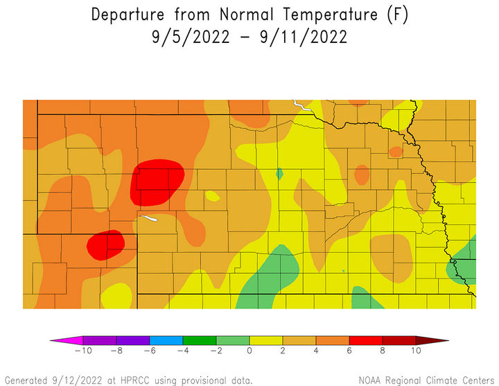
Even with the passage of a cold front late in the week that resulted in maximum temperature dropping 15-20°F below normal, most locations across the state reported above-normal temperature anomalies last week (Figure 1). The western half of Nebraska reported average temperature anomalies for Sept. 5-11 that ranged from 2-8°F above normal. The most intense anomalies (6-8°F above normal) were located along the southwest Nebraska–Colorado border northward through the western one-third of the Sandhill region. Further east, average temperature anomalies were 2°F below normal to 4°F above normal.


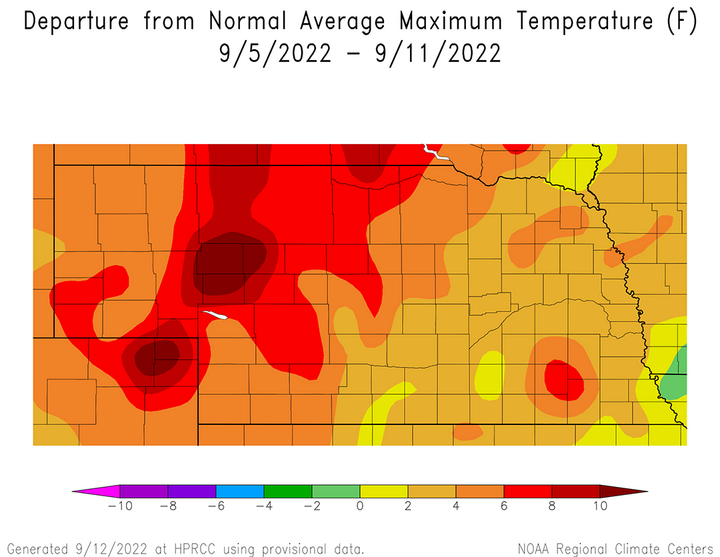
It is apparent that maximum temperatures anomalies (Figure 2) were a significant contributor to above-normal average temperature anomalies depicted in Figure 1. Maximum temperature were 4-12°F above normal for the western half of the state and normal to 6°F above normal across eastern Nebraska. The strongest maximum temperature anomalies across western Nebraska occurred in the same locations reporting average temperatures that were 4-8°F above normal. Eastern Nebraska maximum temperature anomalies were normal to 4°F above normal, except for a small pocket in the Beatrice/Fairbury area where anomalies were 4-6°F above normal.
The daily maximum temperature extremes for airport locations reported by the National Weather Service (NWS) are as follows: Sept. 5 — 103°F (Chadron), Sept. 6 — 104°F (Ogallala), Sept. 7 — 103°F (Scottsbluff), Sept. 8 — 106°F (Ogallala, Valentine), Sept. 9 — 92°F (Falls City), Sept. 10 — 73°F (Norfolk), Sept. 11 — 83°F (Chadron).
The daily minimum temperature extremes for airport locations reported by the NWS are as follows: Sept. 5 — 46°F (Ord), Sept. 6 — 47°F (Alliance), Sept. 7 — 47°F (Alliance), Sept. 8 — 54°F (Imperial), Sept. 9 — 47°F (Kimball), Sept. 10 — 42°F (Valentine), Sept. 11 — 34°F (Alliance, Sidney).

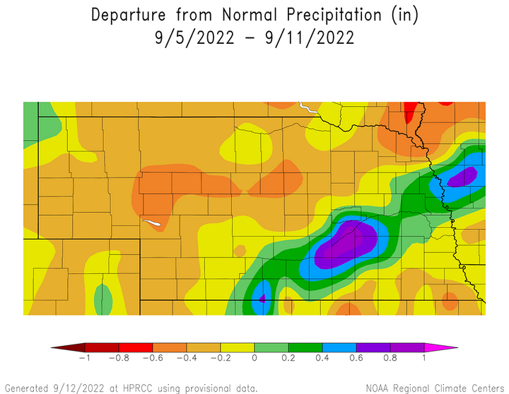
As mentioned earlier, a strong cold front pushed through the state to end the work week and brought widespread measurable moisture to the southeastern half of Nebraska. Precipitation was virtually nonexistent across the state Sept. 5-8 due to dry air at the surface, so the majority of precipitation totals depicted in Figure 3 for Sept. 5-11 actually fell Sept. 9-10. The heaviest band of moisture (0.70-1.50 inches) fell along a line from Holdrege to north of Omaha. The heaviest bands of moisture (1.50-2.50 inches) occurred from Central City/Aurora east-northeast to Osceola and along the Missouri River in northeastern Washington county and eastern Burt county.
The daily maximum precipitation values reported from NERain observers are as follows: Sept. 5 — 0.02 inches (Wymore 8.1 SSW), Sept. 6 — 0.00 inches (all stations), Sept. 7 — 0.00 inches (all stations), Sept. 8 — 0.03 inches (Bayard 13.5 NNE), Sept. 9 — 0.92 inches (Gering 0.4 E), Sept. 10 — 2.65 inches (Benedict 3.5 W), Sept. 11 — 0.87 inches (Diller 5.6 S).
Crop Progress
The rainfall event late last week help improve topsoil moisture estimates slightly but had no impact on subsoil moisture rankings. This is likely due to heat and low rainfall totals for the western one-third of the state, along with rainfall totals of less than an inch over a sizeable area of eastern Nebraska. Typical soils in eastern Nebraska hold two inches of available moisture per foot of soil, so an inch of moisture would be equivalent to bring the top six inches to field capacity.
NASS estimates that as of Sept. 11, topsoil moisture across the state is rated 47% very short, 35% short, 18% adequate and 0% surplus. Compared to Sept. 4 estimates, there was a two-percentage point decrease in the short rating and an equivalent increase in the fair category. Subsoil moisture is currently rated 43% very short, 37% short, 20% adequate and 0% surplus. The only change from Sept. 4 subsoil moisture estimates was a one-percentage point increase in the very poor rating and an offsetting one-percentage point decrease in the short rating.
Even with the precipitation that fell across the southeastern half of Nebraska Sept. 9-10, crop condition improvements were subdued according to the Nebraska Agricultural Statistics Service (NASS). Although moisture was welcome for crops in eastern Nebraska that had not reached physiological maturity, the relentless heat and disappointing precipitation totals across the western one-third of the state likely offset most of the benefits of this precipitation event.
NASS reports that the state sorghum crop continues to deteriorate and is currently rated 44% very poor, 22% poor, 14% fair, 15% good and 5% excellent as of Sept. 11. Compared to a week earlier, there was a nine-percentage point increase in the very poor category, a five-percentage point reduction in the poor category and a four-percentage reduction in the fair category. Since sorghum rated good to excellent was unchanged at 20% from the previous week, the increase in the very poor category came at the expense of the poor and fair categories. Fourteen percent of the crop was estimated to be mature, which is behind last year’s pace of 24% and the five-year average of 17%. One percent of the crop has been estimated to be harvested as of Sept. 11.
There was improvement and deterioration to the condition of the soybean crop last week, according to NASS. Soybeans rated good to excellent gained two percentage points from the Sept. 11 estimates, but the poor to very poor category also gained two percentage points. There was a four-percentage point reduction in the fair category, so it is likely in areas with excessive heat deteriorated and areas receiving moisture improved slightly. NASS currently rates the soybean crop as 13% very poor, 17% poor, 27% fair, 34% good and 9% excellent. NASS estimates that 43% of the soybean crop is dropping leaves, equal to last year and ahead of the five-year average of 37%. Harvested acres still remain under 1% of the acreage dedicated to soybean production.
Although the condition of the corn crop deteriorated across western Nebraska in response to high temperatures in the upper 90s to low 100s, it was more than offset by the precipitation event over the southeastern half of the state. NASS indicates that as of Sept. 11, the state corn crop is rated 18% very poor, 16% poor, 24% fair, 31% good and 11% excellent. Compared to the previous week, corn rated very poor to poor increased one percentage point to 33%, while corn rated good to excellent expanded three percentage points to 42%. Crop maturity is estimated at 36%, which compares to 33% last year and the five-year average of 27%. One percent of the crop has been harvested, according to NASS.
The condition of pastures and rangeland were essentially unchanged from the previous week, according to NASS. As of Sept. 11, pasture and rangelands were rated 50% very poor, 28% poor, 14% fair, 6% good and 2% excellent. The only condition changes from the previous week were a one-percentage point reduction in the fair category and a one-percentage point increase in the excellent category.
Weather Outlook
There appears to be a more aggressive precipitation pattern in the process of developing for the northern half of the High Plains during the next 16 days if the GFS model is correct in its forecast depiction. The most current GFS model run issued the morning of Sept. 13 indicates that the ridge currently bringing high temperatures in the upper 80s to upper 90s to the state will break down as the week progresses. An upper air trough moving into the northwestern United States will eject pieces of energy eastward, which will slowly push the ridge temporarily south of the central Plains.
As energy ejects out of this trough Sept. 15-17, scattered showers and thunderstorms are forecast to develop, primarily across the eastern half of the state Sept. 16-17. The current quantitative precipitation forecast indicates less than 0.50 inches of total moisture, with most areas likely receiving less than a quarter of an inch. This same upper air trough is then forecast to slide down the coast of California before lifting northeast toward the northern Rockies and cutting off from the main jet stream. As the system dives south along the west coast, upper air ridging will build north from the southern Plains Sept. 18-20. High temperatures are forecast to return to the upper 80s to the middle 90s with no measurable moisture.
From Sept. 21 through Sept. 28, the GFS model moves this cutoff upper air low slowly east-southeast from central Montana toward Nebraska. If the GFS is correct, then precipitation on the east side of the upper air low will slowly move across the state Sept. 21-24. If depicted properly, this upper air low has the potential to produce 0.50-1.00 inches of moisture, possibly heavier if widespread thunderstorms can develop. High temperatures would likely drop back into the 70s and 80s due to extensive cloud cover.
This upper air low is finally pushed eastward Sept. 25-28 in response to another upper air trough moving into the northwestern United States. Depending on how quickly the cutoff low shifts eastward, it is possible that lighter precipitation could develop on the backside of the upper air low and primarily impact the eastern half of Nebraska. Precipitation totals are currently forecast to be less than 0.50 inches and high temperatures are expected to be in the 70s to middle 80s during this period, but could be 5°F warmer if this cutoff upper air low moves quicker than forecast.
As has been mentioned in earlier editions, forecast confidence deteriorates when upper air lows are depicted to cutoff from the jet stream steering currents. Since there is no jet stream to push them on a defined path, they will spin like a top and produce an erratic storm track that is difficult to forecast accurately. From a positive standpoint, a good moisture event is currently being depicted by the GFS. On a negative note, confidence on the eventual path of this upper air low is lacking and I wouldn’t be surprised to see the GFS model overdo expected precipitation and/or eliminate this outcome in future model runs.
