Weather Review
Dry conditions dominated Nebraska’s weather last week, which allowed corn and soybean producers to stay ahead of last year’s harvest pace, as well as the average for the past five years. Although precipitation delays were not an issue last week, strong winds and dry surface conditions on Oct. 17, 18 and 23 created dangerous fire conditions. Winds were particularly severe on Oct. 23 with sustained winds of 25-35 mph and gusts of 45-60 mph across the eastern two-thirds of the state.
There were several fires that broke out across the state on Sunday (Oct. 23), as well as western Iowa, northern Kansas, northwest Missouri and eastern South Dakota. These fires were particularly difficult to suppress with the strong winds but were also mitigated to some extent by the lack of standing crops due to the rapid harvest pace this year. Fires that broke out across southern Lancaster County impacted a 10 square mile area between Hallam and Firth causing the destruction of three buildings and injuring at least two firefighters.
These windy conditions were the result of several frontal boundaries moving through the state. The first system (Oct. 17) brought a strong cold front through the state resulting in two days where minimum temperatures ranged from 12°F to 25°F for areas east of the Panhandle. The upper air low responsible for this influx of air stalled over the Great Lakes for several days before sliding east this past weekend. This allowed high pressure to build eastward from the western United States and brought record warmth to eastern Nebraska on Oct. 23.
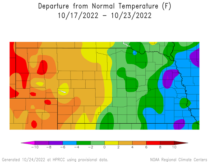
The cumulative temperature impact of these surface fronts were more pronounced across eastern Nebraska. According to Figure 1, the eastern half of Nebraska was 2–8°F below normal, with anomalies of 4–8°F below normal across the eastern fourth of the state. For western Nebraska, average temperature anomalies ranged from 2°F to 8°F above normal, with the greatest anomalies (6–8°F) occurring across the western half of the Panhandle.
The greatest factor contributing to the large spread between negative anomalies (east) and positive anomalies (west) was the position of the upper air trough that stalled over the Great Lakes region. Eastern Nebraska was positioned on the backside of this upper air trough, which funneled cold Canadian air southward into the region. Western Nebraska was positioned closer to the western upper air ridge and only received a glancing blow from the cold air before rapidly warming as the ridge pushed slowly eastward.
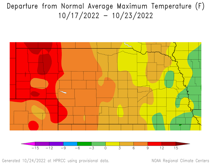
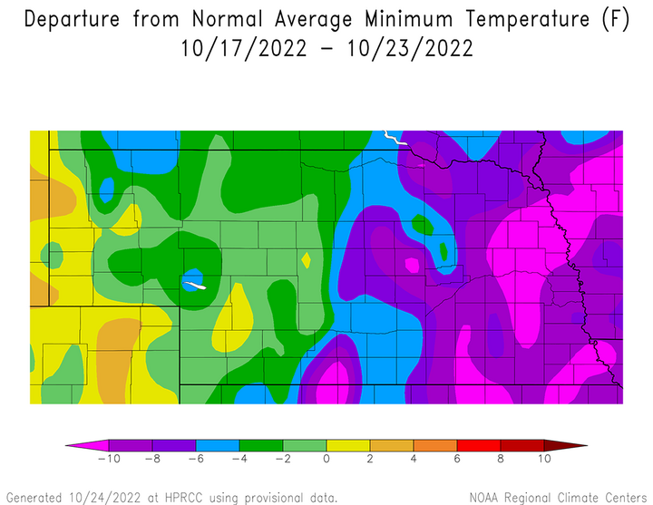
Figure 2 shows maximum temperature anomalies across the state for the past week. The eastern one-third of Nebraska had average maximum anomalies ranging from 3°F below normal to 3°F above normal, with the coldest anomalies along the Missouri River. The anomalies ranged from 3°F to 15°F above normal across the western two-thirds of Nebraska, with the anomalies of 9°F to 15°F above normal across the Panhandle. Average minimum temperature anomalies (Figure 3) ranged from 2°F above normal across the western half of the Panhandle to 12°F below normal across eastern Nebraska, which was positioned on the western flank of the Great Lakes upper air trough.
The daily maximum temperature extremes for airport locations reported by the National Weather Service (NWS) are as follows: Oct. 17 — 64°F (Chadron, Scottsbluff), Oct. 18 — 69°F (Scottsbluff), Oct. 19 — 80°F (Scottsbluff), Oct. 20 — 88°F (Chadron, Scottsbluff), Oct. 21 — 87°F (Falls City), Oct. 22 — 88°F (Broken Bow, Kearney, Lexington and Ord), Oct. 23 — 90°F (Grand Island).
The daily minimum temperature extremes for airport locations reported by the NWS are as follows: Oct. 17 — 21°F (Alliance), Oct. 18 — 13°F (Tekamah), Oct. 19 — 12°F (Tekamah), Oct. 20 — 25°F (Alliance), Oct. 21 — 30°F (Chadron), Oct. 22 — 29°F (Ord), Oct. 23 — 27°F (Alliance).
The only precipitation recorded during the past week according to NERain observers was in the Grant area where 0.18 inches of moisture was reported on Oct. 23. Since these observers take morning readings, any precipitation that fell after mid-morning would not be reported until observations were submitted on Oct. 24. Therefore, the scattered showers and thunderstorms that occurred across eastern Nebraska during the evening hours on Sunday will appear in next week’s weekly weather update. With only one location reporting measurable moisture last week, there is no precipitation graphic available to show the distribution of precipitation across the state from Oct. 17 through Oct. 23.
The daily maximum precipitation values reported from NERain observers are as follows: Oct. 17–Oct. 22 — 0.00 inches (all stations), Oct. 23 — 0.18 inches (Grant 5.1 WNW).
Crop Progress
With a week of precipitation-free weather, the soybean harvest is nearing completion and corn passed the two-thirds completion mark as of Oct. 23, according to the Nebraska Agricultural Statistics Service (NASS). The Nebraska soybean crop is estimated to be 93% complete, which compares to 86% last year and the five-year average if 76%. This year’s corn harvest is estimated to be 65% complete, which is ahead of last year’s pace of 57% and the five-year average of 46%.
Although the grain sorghum harvest has passed the halfway point (55%), it trails last year’s pace of 70%, but is ahead of the five-year average of 52%. If weather models are correct in regard to precipitation chances through this coming weekend, the sorghum harvest should be near 75% completion when NASS releases their crop progress estimates Oct. 31.
The lack of moisture statewide this past week means that there were no improvements to pastures and rangeland conditions, as well as topsoil and subsoil moisture estimates. As of Oct. 23, NASS estimates rangeland and pasture conditions across the state as 50% very poor, 32% poor, 17% fair, 1% good and 0% excellent. Topsoil moisture was rated 47% very short, 37% short, 16% adequate and 0% surplus. Subsoil moisture ratings are nearly identical to topsoil estimates and NASS currently rates subsoil moisture as 46% very short, 38% short, 16% adequate and 0% surplus.
Outlook
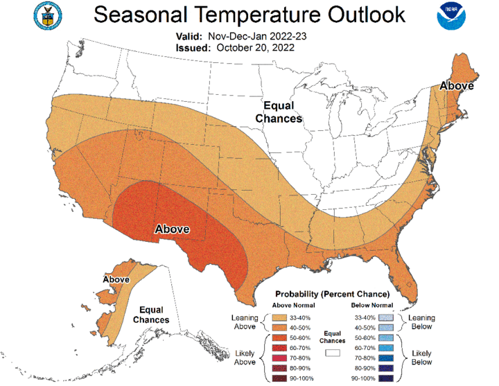
Before looking at the short-term model outlooks, the Climate Prediction Center (CPC) released what amounts to their winter outlook on Oct. 20. Above-normal temperatures are forecast from southern Oregon eastward through northern Wyoming, then southeastward to northwest Arkansas. This area continues along the Gulf of Mexico, then up the eastern United States seaboard (Figure 4). The southwestern three-fourths of Nebraska has been assigned a weak chance for below-normal temperatures.
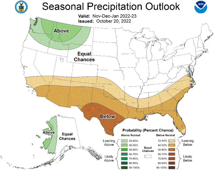
Below normal winter precipitation is forecast from southern California eastward through southwest Kansas, then southeastward through the Gulf of Mexico states and up the eastern U.S. seaboard east of the Appalachians (Figure 5). The highest probability of occurrence has been assigned to extreme southeastern New Mexico and the southern one-third of Texas. CPC assigns equal odds for above-normal, normal and below-normal moisture across the entire state of Nebraska.
The GFS model issued the morning of Oct. 25 indicates that precipitation will be hard to come by until the first full weekend of November. A weak short wave is projected to slide through the central and southern High Plains Oct. 27-28. Over the past five days, the GFS model has consistently moved the precipitation shield associated with this trough to the south, which had been centered over eastern Nebraska last Friday. Currently the GFS projects less than 0.10 inch of moisture for the eastern half of the state.
After this trough moves east of the High Plains, a very strong upper air trough is forecast to move into the Pacific Northwest by Nov. 1, then dive southward along the west coast into southern California by Nov. 3. The GFS model then lifts this system to the central Plains Nov. 4-5 and produces a broad area of precipitation across Kansas, Nebraska and South Dakota. The most current GFS model run develops snowfall in the cold sector of the storm, which currently would target central and western Nebraska with accumulating snowfall. Eastern Nebraska is forecast to be in the warm sector of the storm and is currently forecast to see precipitation in the form of rain.
The upper air trough responsible for this system is forecast to cutoff an upper air low over the southern Plains, similar to the system that impacted the High Plains this past weekend. This upper air low is lifted north-northeast from central Texas Nov. 7-8, with the potential to bring rainfall to the southeastern one-third of the state. Upper air ridging is then forecast to build into the central Plains as the low-pressure system moves east, bringing dry conditions through the end of the model forecast period (Nov. 10).
High temperatures are expected to be in the 60s statewide through Oct. 31st, although the western half of the state may see highs move into the lower 70s. High temperatures Nov. 1-5 are forecast to move into the upper 60s to upper 70s, before dropping into the 40s and 50s Nov. 6-7. Depending on the amount of cold air that gets drawn southward on the backside of the storm system forecast to cross the central Plains, high temperatures could struggle to break the 40°F mark across the western half of the state Nov. 7. High temperatures should gradually warm back into the 50s to low 60s by Nov. 10.
