Weather Review
Due to delays in returning to my office from Michigan, this report will summarize conditions across the state since the last published weekly crop weather update of conditions through Sept. 18.
During the past three weeks, the jet stream continued a pattern that has dominated the second half of Nebraska’s growing season. Strong upper air ridging extending from the southern Plains northwestward through the northern Rockies brought sustained above-normal temperature and little, if any, measurable moisture. These stretches were interrupted weekly by troughs moving from the Pacific Northwest to the western Great Lakes that brought one to two days of below-normal temperatures and scattered pockets of precipitation as surface fronts moved through the state.
These cold frontal passages were insufficient to offset the stretches of above-normal temperatures when upper air ridging was in place over the central Plains. In fact, Lincoln recorded two consecutive days of high temperatures that reached 100°F or higher Sept. 19-20. From a historical perspective, this is the latest date ever recorded with two consecutive days of high temperatures reaching 100°F, along with the second latest date that the high temperature reached 100°F. A season ending freeze hit the northeastern two-thirds of the state the morning of Oct. 9. Tekamah reached 22°F for a state low temperature, with most locations reporting low temperatures ranging from 25°F to 32°F. Even locations that only bottomed out at 32°F had three to four consecutive hours of these conditions, which would be the equivalent to the damage experienced if the low temperature had reached 28°F.
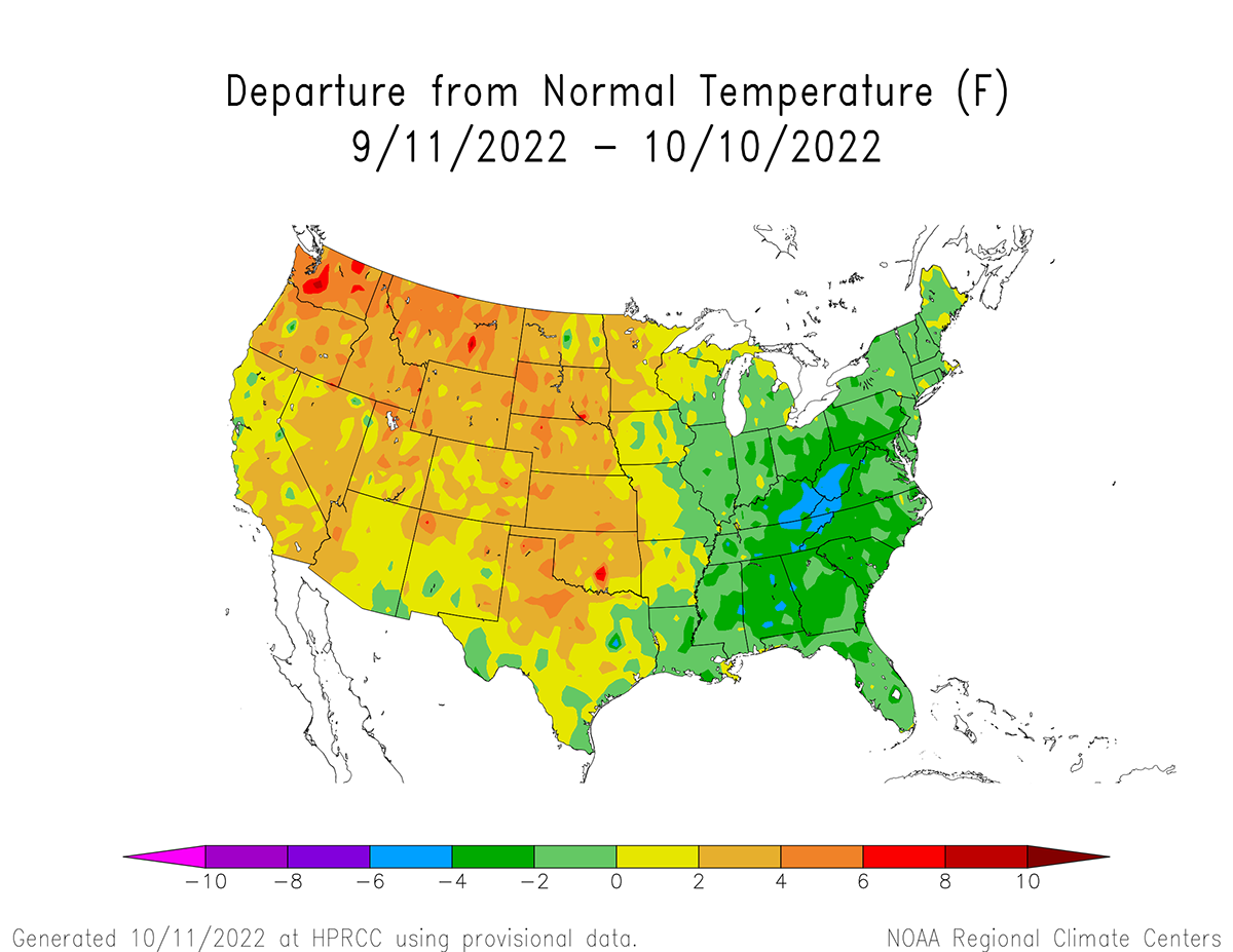
The 30-day average temperature trend (Figure 1) from Sept. 11–Oct. 10 ranges from 2-6°F above normal, while the 14-day trend is slightly cooler with departures from normal running 0-6°F above normal (Figure 2). It is apparent from these two figures that Nebraska has been at the intersection of a below-normal temperature trend for the eastern U.S. and a strong warming trend across the western half of the country.

The daily maximum temperature extremes for airport locations reported by the National Weather Service (NWS) are as follows: Sept. 19 — 100°F (Lincoln), Sept. 20 — 104°F (Lincoln), Sept. 21 — 84°F (Falls City), Sept. 22 — 67°F (Tekamah), Sept. 23 — 83°F (Broken Bow, McCook, Ord), Sept. 24 — 91°F (Lincoln), Sept. 25 — 81°F (Grand Island, Lincoln, Tekamah), Sept. 26 — 87°F (Scottsbluff), Sept. 27 — 85°F (McCook), Sept. 28 — 88°F (Chadron, Scottsbluff), Sept. 29 — 94°F (Chadron), Sept. 30 — 91°F (McCook), Oct. 1 — 89°F (McCook), Oct. 2 — 89°F (North Platte), Oct. 3 — 89°F (North Platte), Oct. 4 — 85°F (Falls City), Oct. 5 — 79°F (Grand Island), Oct. 6 — 80°F (Falls City), Oct. 7 — 60°F (Lincoln), Oct. 8 — 71°F (Broken Bow), Oct. 9 — 80°F (Tekamah).
The daily minimum temperature extremes for airport locations reported by the NWS are as follows: Sept. 19 — 48°F (Kimball), Sept. 20 — 47°F (Alliance), Sept. 21 — 47°F (Gordon), Sept. 22 — 44°F (Kimball, Sidney), Sept. 23 — 43°F (Alliance, Kimball), Sept. 24 — 36°F (Alliance), Sept. 25 — 33°F (Alliance), Sept. 26 — 32°F (Alliance, Gordon, Valentine), Sept. 27 — 36°F (Alliance), Sept. 28 — 33°F (Wayne), Sept. 29 — 36°F (Tekamah), Sept. 30 — 44°F (Alliance, Kimball), Oct. 1 — 43°F (Sidney), Oct. 2 — 42°F (Chadron), Oct. 3 — 42°F (Chadron), Oct. 4 — 41°F (Sidney), Oct. 5 — 36°F (Alliance), Oct. 6 — 36°F (Alliance), Oct. 7 — 32°F (O’Neill), Oct. 8 — 22°F (Tekamah), Oct. 9 — 28°F Broken Bow, Gordon).
There has been an uptick in precipitation coverage across the Panhandle, southwest, south-central and west-central Nebraska since mid-September, which follows a strong dry trend for most of the growing season. Even with this recent moisture, precipitation over the past two weeks (Figure 3) has been below normal except for the northeast and southwest corners of the Panhandle. Most of the eastern one-third of the state has missed out on recent precipitation events and accumulated precipitation deficits range from 1.00 to 1.50 inches just in the past two weeks alone.

October is a critical month for building soil moisture reserves for next growing season, establishing wheat stands and providing moisture for fall pasture growth. Unfortunately, short term models indicate at least another seven to 10 days of little to no moisture is in store for Nebraska. This means that the final 10 days of this month will need an active weather pattern to offset this poor start to the soil moisture recharge season (October-April).
The daily maximum precipitation values reported from NERain observers are as follows: Sept. 19 — 0.78 inches (Franklin 0.3 SSW), Sept. 20 — 0.01 inches (Brule 8.6 NNE), Sept. 21 — 0.60 inches (Superior 8.4 NW), Sept. 22 — 1.40 inches (Benkelman 4.9 NW, Lamar 3.4 S), Sept. 23 — 1.31 inches (Man 4.6 WNW), Sept. 24 — 0.40 inches (Verdon 9.5 SSW), Sept. 25-29 — 0.00 inches (all stations), Sept. 30 — 0.31 inches (Gurley 1.3 W), Oct. 1 — 0.75 inches (Kimball 13.3 SSW), Oct. 2 — 0.38 inches (Ashby 8.6 SSW), Oct. 3 — 0.56 inches (Springview 7.7 SSW), Oct. 4 — 0.85 inches (Potter 7.1 N), Oct. 5 — 0.50 inches (Cairo 0.4 ESE), Oct. 6 — 0.09 inches (Hardy 4.3 E), Oct. 7 — 1.20 inches (Arthur 0.1 S), Oct. 8 — 0.36 inches (Minden 2.2 ESE), Oct. 9 — 0.00 inches (all stations).
Crop Progress
During the past three weeks, harvest activity has steadily increased due to the lack of widespread precipitation across the state. Even where precipitation developed, dry topsoils from this year’s drought easily absorbed the moisture without creating muddy conditions that would halt harvest activity for more than two days. Soybean harvest activity is likely to progress rapidly over the next 10 days with a dry forecast following a season ending frost/freeze across the northeastern two-thirds of the state. Producers have been reporting that green stemmed soybeans and weeds have slowed down combine harvest speeds, which should no longer be an issue with this freeze event.
Nebraska Agricultural Statistics Service (NASS) estimates that the state soybean crop is 54% complete as of Oct. 9. One week ago (Oct. 2) the soybean harvest was estimated to be 29% complete and was 13% complete two weeks ago (Sept. 25). A year ago, the soybean harvest was 56% complete and the comparable five-year average for Oct. 2 is 42%. With a dry forecast for the next 10 days, the amount of soybeans harvested in next week’s crop report should surpass 75%.
The state corn harvest as of Oct. 10 is estimated to be 34% complete according to NASS. On Oct. 2, the state corn harvest was estimated to be 24% complete and was 13% complete on Sept. 25. A year ago, the corn harvest was estimated to be 28% complete and the comparable five-year average is 22%. Corn harvest activity should increase at a faster weekly pace now that the soybean harvest has exceeded 50% and will likely approach 50% complete in next week’s crop report with favorable harvest weather.
The state sorghum harvest this year has consistently trailed last year’s pace, as well as the five-year average. Drought stress has delayed maturity across southwest and south-central Nebraska where most of the sorghum crop is grown. NASS reports that only 75% of the crop is mature as of Oct. 9, which compares to 89% last year and the five-year average of 87%. These areas have also seen better moisture events over the past 30 days, which has likely led to minor harvest delays. As of Oct. 9, 16% of the sorghum crop has been harvested according to NASS, which compares to 36% last year and the five-year average of 23%.
Since warm-season crops are in their “harvest” phase of the production season, crop ratings will no longer be updated. However, they are still important in regard to pastures and rangeland, as well as the 2023 wheat crop. NASS estimates that 86% of the state winter wheat crop has been planted and 52% has emerged as of Oct. 9. No crop ratings were provided by NASS for this current wheat crop that just passed the halfway point for emergence but will likely become available within the next two weeks as the crop enters its establishment phase.
There has been an uptick in precipitation across parts of the southwest, south-central and the northern Panhandle. However, rangeland and pastures conditions have shown little improvement due above-normal temperatures and sustained precipitation events. NASS estimates that as of Oct. 9, pasture and rangeland conditions were rated 45% very poor, 37% poor, 15% fair, 3% good and 0% excellent. Topsoil and subsoil moisture ratings are almost identical to pasture and rangeland conditions according to NASS. Topsoil moisture as of Oct. 9 was rated 44% very short, 38% short, 18% adequate and 0% surplus. Subsoil moisture was rated 46% very short, 34% short, 20% adequate and 0% surplus.
Outlook
A cold front slid through the state on Oct. 11 leading to development of a line of thunderstorms that moved across southeastern Nebraska during the late evening hours. NERain observations indicate 0.25-0.75 inches of moisture fell south and east of a line from Omaha to Hebron. Instability showers were observed across eastern Nebraska on Oct. 12, but precipitation totals were generally under 0.10 inches. The upper air trough responsible for this cold front is forecast to intensify as it moves into the western Great Lakes. Widespread moisture is expected across the eastern half of the Corn Belt for the remainder of this week, which will bring harvest activity to a grinding halt. Air temperatures will struggle to reach the mid 50s across Wisconsin, Michigan, Indiana and Ohio.
Nebraska is forecast to be positioned on the western flank of this upper air trough, with the eastern half of the state bearing the brunt of this cool air mass. High temperatures will likely remain in the 60s east through this weekend, then slowly moderate next week as an upper air ridge to our west moves eastward. Western Nebraska has a better chance of seeing air temperatures move into the 70s the second half of this this coming weekend. High temperatures are forecast to warm into the 70s east to low 80s west during the first half of next week as the upper air ridge moves overhead. Cooler air will arrive when the upper air trough pushes toward the central Plains during the second half of next week. Unfortunately, the most current GFS model run issued the morning of Oct. 12 shows no precipitation developing across Nebraska until Oct. 21 at the earliest.
During the past couple of days, the GFS model has hinted that a strong upper air trough will move into the Pacific Northwest Oct. 18-22. The reason for a four-day spread for this trough to move through the northwestern United States is that GFS model has offered completely different solutions depending on which model run is examined. On Monday, the GFS model hinted at snows across eastern Montana and western North Dakota Oct. 21-22, then an additional wave was forecast to follow it and move across Nebraska. Yesterday this feature disappeared and today the GFS now indicates a stormy pattern in possible for the northern half of the High Plains Oct. 21-23.
In short, the GFS model is hinting at an overall pattern change that would shift away from an upper air trough across the eastern Corn Belt to an upper air ridge as we move into the last third of October. This would allow for more storm activity to enter the western United States, with that energy moving eastward toward the central and northern High Plains. I suspect that there will be numerous revisions to the eventual path of the surface low(s) associated with this upper air trough and precipitation may turn out to be a bust like previous systems. However, producers and ranchers should pay particular attention to the evolution of this trough as we are now entering the time of year where significant early snowstorm activity normally begins to develop across the continental United States.
