Weather Review
The upper air trough responsible for a cold frontal passage through the state on Oct. 23 split its energy into a northern and southern stream storm. The northern stream energy slid eastward toward the western Great Lakes and weakened, but the southern stream energy formed a semi-cutoff low that moved slowly northeastward from north-central Texas. Areas southeast of a Omaha to Fairbury line were on the northern periphery of this upper air low and received 0.15-0.40 inches of precipitation Oct. 24, while the remainder of the state remained precipitation-free.
A cool air mass following the surface cold front pushed minimum temperatures into the teens to low 20s across the western third of Nebraska Oct. 25-30. Since this air mass had Canadian origins, relative humidity levels were consistently below 30%, which allowed maximum temperatures to rebound into the 60s to low 70s. A weak trough pushed the state Oct. 27 and generated an overrunning precipitation event through the central third of the state as warm air across southeastern Nebraska was lifted over the top of the cooler air mass across western Nebraska.
This mid-level trough moved southeast toward northern Texas, then lifted northeast toward the Ohio River valley Oct. 28-30. Although there was an increase in cloud cover across eastern Nebraska as the low lifted northeast, precipitation was confined to areas south and east of the state. High temperatures across the state Oct. 29-30 were in the middle 60s to low 70s with very light winds and low relative humidity levels, the perfect ingredients for harvest weather.
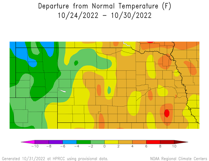
The cumulative impacts of below-normal minimum temperatures and near-normal maximum temperatures across western Nebraska led to below-normal temperatures for the Panhandle and northern Sandhills region (Figure 1). Average temperature anomalies were 2-6°F below normal across the northern Panhandle, 2-4°F below normal across the central Panhandle and 0-2°F below normal across the southern Panhandle. Further east, average temperature anomalies were generally 2-6°F above normal across eastern Nebraska.

The daily maximum temperature extremes for airport locations reported by the National Weather Service (NWS) are as follows: Oct. 24 — 77°F (Fremont, Lincoln, Tekamah), Oct. 25 — 66°F (McCook), Oct. 26 — 64°F (Imperial), Oct. 27 — 65°F (Falls City, Lincoln), Oct. 28 — 68°F (Scottsbluff), Oct. 29 — 73°F (O’Neill), Oct. 30 — 71°F (Lincoln).
The daily minimum temperature extremes for airport locations reported by the NWS are as follows: Oct. 24 — 27°F (Kimball, Scottsbluff), Oct. 25 — 19°F (Alliance, Broken Bow), Oct. 26 — 19°F (Gordon), Oct. 27 — 19°F (Gordon), Oct. 28 — 14°F (Alliance), Oct. 29 — 19°F (Alliance), Oct. 30 — 19°F (Alliance).
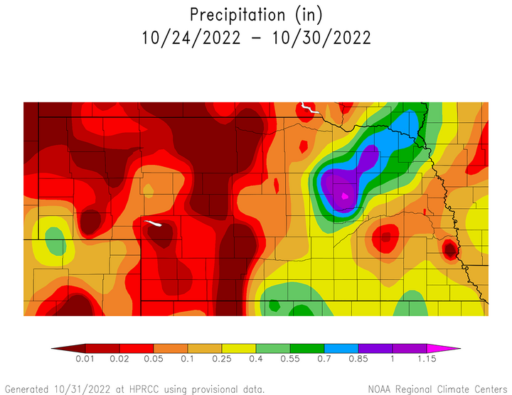
Although precipitation that fell this past week was welcome for those fortunate enough to receive it, much of the state struggled to even record a 0.10 inch of moisture (Figure 2). The western third of Nebraska received less than 0.10 inches of moisture, with nearly three-fourths of the Panhandle reporting nothing to 0.05 inches of precipitation. Further east, precipitation totals exceeded 0.25 inches from south-central through northeast Nebraska. NERain observers reported between 0.70 and 1.15 inches from North Loup to Vermillion, South Dakota. Most locations east and southeast of the central third of the state reported less than 0.25 inches of moisture.
Nebraska depends on precipitation to build soil moisture reserves during the fall through spring period because precipitation during the growing season is climatically insufficient to supply warm-season crops with all of their moisture needs. Usually, we track the precipitation from Oct. 1 through April 30 as a leading indicator for drought risk across eastern Nebraska dryland crop acres. Research in the 1980s by agricultural climatologists with the University of Nebraska-Lincoln found that for each one inch of moisture shortfall during the soil moisture recharge season, coupled with normal growing season weather, results in an average dryland decline of 2.5% compared to trend adjusted yields.


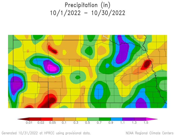
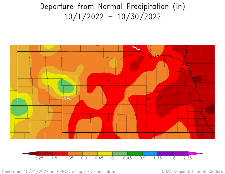
Figure 3 shows the accumulated moisture received from Oct. 1-30, while Figure 4 indicates the cumulative anomalies that have developed since the beginning of October. There are only a couple of small pockets across the state that have received more than 0.50 inches of moisture so far this month that lie outside of the region that received moisture last week. More importantly, even with last week’s rainfall, there are only two small pockets of above-normal October moisture this year: west-central Nebraska and the extreme southwestern corner of the Panhandle.
According to Figure 4, outside of the small pocket of surplus moisture, areas east of the Panhandle have accumulated precipitation deficits of at least 0.90 inches of moisture. These deficits increase to at least 1.35 inches across the eastern fourth of the state (primarily dryland cropping region). The most significant precipitation deficits (1.80-2.50 inches) accumulated this October lie across east-central Nebraska and the counties bordering the Missouri river from South Sioux City to Falls City. If the precipitation forecast with the storm system expected to impact Nebraska Nov. 3-5 verifies, precipitation deficits across eastern Nebraska should shrink 0.50 to 1.50 inches.
The daily maximum precipitation values reported from NERain observers are as follows: Oct. 24 — 0.40 inches (Boelus 3.2 NE, Kimball 13.3 SSW), Oct. 25 — 0.41 inches (Barneston 0.3 N), Oct. 26 — 0.00 inches (all stations), Oct. 27 — 0.42 inches (Saint Edwards 7.3 WSW), Oct. 28 — 1.00 inches (Coleridge 3.5 W), Oct. 29-30 — 0.00 inches (all stations).
Crop Progress
Although precipitation coverage during this past week was primarily limited to the central third and extreme southeast Nebraska, it was sufficient to slightly improve statewide topsoil moisture ratings, along with rangeland and pasture conditions. Nebraska Agricultural Statistics Service (NASS) rates rangeland and pasture conditions as of Oct. 30 at 44% very poor, 38% poor, 16% fair, 2% good and 0% excellent. This represents a 6-percentage point decline in the "very poor" rating from the prior crop progress report and a subsequent increase of 6 percentage points in the "poor" category.
Topsoil moisture as of Oct. 30 was rated 44% very short, 41% short, 15% adequate and 0% surplus. This represents a one week change of 3 percentage points reduction in the "very short" category, a 4-percentage point increase in the "short" category and a one-point increase in the "adequate" category. In essence, the major movement this past week was to slightly improve "very short" conditions with an expansion into the "short" category. Subsoil moisture ratings were identical to Oct. 23 crop report with 46% of the state rated very short, 38% rated short, 16% rated adequate and 0% rated surplus.
Wheat emergence as of Oct. 30 is estimated to be 94% by NASS, which compares to 89% last year and the five-year average of 90%. Moisture was sufficient to get the crop emerged according to extension educators with the University of Nebraska, but the lack of moisture these past two weeks is stressing young plants with small rooting systems. The condition of the wheat crop according to NASS is estimated to be 15% very poor, 23% poor, 40% fair, 21% good and 1% excellent.
Harvest activity was slowed down one to two days across the middle third of Nebraska due to the Oct. 27 precipitation event, but the remainder of the state proceeded without delays. NASS estimates that the soybean harvest is 97% complete as of Oct. 30, which compares to 91% last year and the five-year average of 89%. The corn harvest is estimated at 80% complete, which compares to 70% last year and the five-year average of 61%. The sorghum harvest is estimated at 75% complete, which compares to 77% last year and ahead of the five-year pace of 65%. The pace of this year's harvest has been aided by dry weather, as well as below-normal dryland crop yields requiring less combine time across eastern Nebraska.
If weather models are correct regarding the precipitation forecast for the remainder of this week, the eastern half of the state will likely see harvest activity grind to a halt Nov. 3-5 due to a slow-moving upper air trough crossing the central High Plains. Accumulated precipitation for this event ranges from 0.50 inches across northeast Nebraska to 2.25 inches along the Kansas/Nebraska border in southeast Nebraska. The western half of the state is forecast to receive less than 0.50 inches moisture, so harvest activity may only be delayed one to two days.
Outlook
A significant upper air trough is currently moving on to the west coast of the United States and is forecast to move into the High Plains region on Nov. 3. The Storm Prediction Center in Norman, Oklahoma currently places most of eastern Nebraska in the slight risk category for severe weather, primarily wind and hail along the surface cold front. They also place a marginal risk of severe weather from north-central and northeast Kansas southwestward through the eastern half of the Texas Panhandle.
The GFS model has been alternating between a progressive upper air trough and one that forms a semi-cutoff low over north-central Texas. If this upper air trough is progressive, precipitation will likely move east of Nebraska by the evening of Nov. 4. If a semi-cutoff upper air low forms, precipitation across the southeastern third of the state could linger through Nov. 5. High temperatures should cool from the 70s Nov. 1-2, into the 50s and 60s Nov. 3-5.
A warming trend is forecast for Nebraska Nov. 6-8, with highs pushing into the upper 60s to low 70s as another upper air trough builds into the western United States and pushes atmospheric ridging into the central and southern High Plains. This trough is currently forecast to move into the central/northern Plains Nov. 9-10, with precipitation currently forecast for the Dakotas and Minnesota. The GFS model indicates northeast Nebraska has the best chance of receiving moisture with this system. However, it should be noted that this same model has been shifting this precipitation shield between the Dakotas and Nebraska over the last two days, so the possibility exists for more precipitation activity across the state than is currently forecast.
High temperatures with this trough are forecast to drop back into the 50s, possibly into the 40s across the northern fourth of the state. After a brief lull in activity Nov. 11-12, another upper air trough is forecast to cross the northern/central Rockies and move into the central High Plains Nov. 13. Currently, the GFS model indicates the primary precipitation shield will be across Nebraska Nov. 13-14 and it indicates that air temperatures may be cold enough to produce some snowfall across the northwestern third of the state.
Even though we have had below-normal precipitation across most of Nebraska during this past month, it appears that an active weather pattern will develop across the western half of the United States during the first half of November. At present, the GFS model is indicating three respectable chances for moisture across the state and the opportunity to cut into some of the precipitation deficits that have occurred at the start of our soil moisture recharge season.
