Weather Review
High temperatures during the past week (May 23-29) were well below normal to start the period before warming dramatically in response to atmospheric ridging over the central United States May 27-30. Even with the warmup during the second half of the week, average temperatures were below normal for the vast majority of the state, as depicted in Figure 1. Average temperatures were 3-5°F below normal across southeast, south-central and northeast Nebraska. The remainder of the state had average temperature departures of 1-3°F below normal, except for the northwest Panhandle and northeastern Sandhills where average temperature anomalies were up to 2°F above normal.
Daily high temperatures May 23-25 were in the 50s and 60s statewide but warmed into the 70s and 80s across the western half of the state May 26-27. The eastern half of the state was slower to warm up as cloud cover limited daytime heating and high temperatures ranged from 55°F to 65°F May 26. As the western United States upper air ridge was forced eastward in response to a strong upper air trough moving through the west coast, high temperatures statewide were consistently in the middle 80s to lower 90s May 28-29.

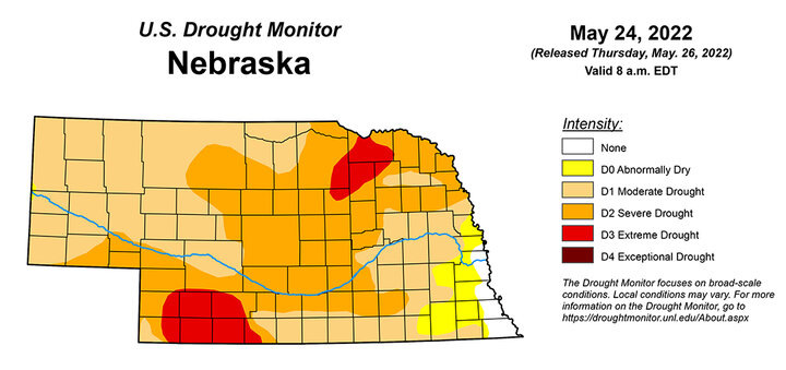
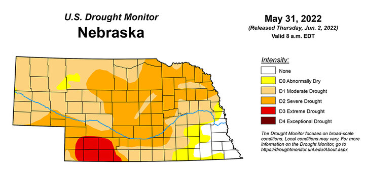
Widespread precipitation developed across the southeastern half of the state May 24-25 in response to an upper air low that developed over north-central Texas and moved northward across eastern Nebraska and western Iowa. Cool air at the surface eliminated thunderstorm potential, but warmer air aloft pushed over the surface air mass and produced a long-lived steady rain event that lasted almost 48 hours. Areas south and east of a line from Red Cloud to Omaha received 2-5 inches of moisture, with 1-2 inches of moisture reported from Holdrege to West Point. It was anticipated that areas receiving at least two inches of moisture last week would likely show improvement in this week’s U.S. Drought Monitor depiction (Figure 2a, 2b).
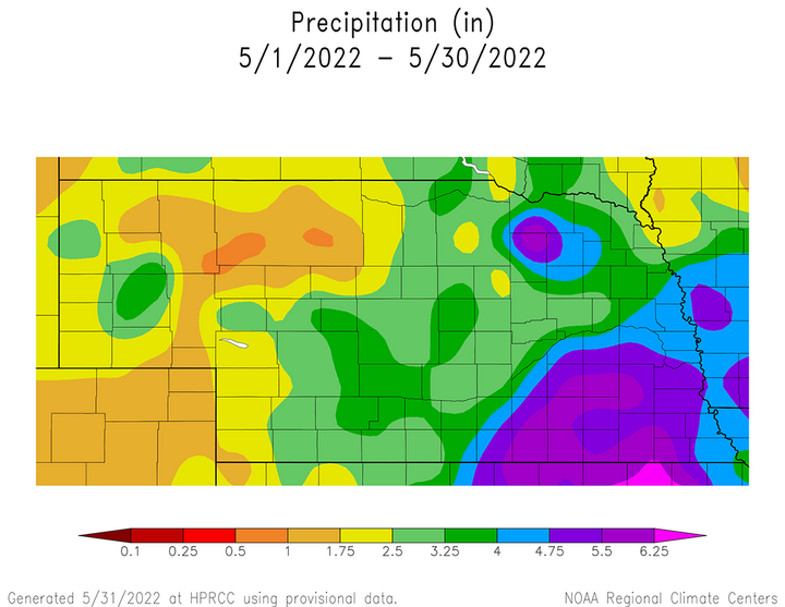
With this event, cumulative precipitation totals from May 1-30 exceed four inches south and east of a line from Red Cloud to West Point, as well as a pocket around the Norfolk to O’Neill area as seen in Figure 3. Less than 2.5 inches of moisture have fallen across the Panhandle, as well as parts of southwest, west-central and north-central Nebraska. The remainder of the state has received between 2.50 and 4.00 inches, with the higher totals falling just west of the four-inch line in eastern Nebraska.
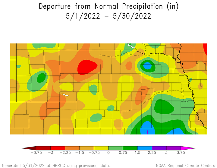
May and June are Nebraska’s two wettest months of the year, so we should expect monthly totals ranging from 3.5 inches over the northwest Panhandle to just over five inches in extreme southeast Nebraska. So even though some impressive rainfall totals came out of last week’s system, surplus precipitation anomalies are generally confined to southeast and south-central Nebraska, with a range of normal to 1.50 inches above normal according to Figure 4. Below normal anomalies of 0.75-2.25 inches are prevalent across the eastern Panhandle and north-central Nebraska, as well as pockets of southwest, south-central, central, northeast and southeast areas of the state. It should be noted that rain and thunderstorms were widespread across the northern Panhandle and the western half of north-central Nebraska May 31 and are not included the graphics for Figures 3 and 4.
Current Crop Conditions
Although most locations in the southeastern half of the state received greater than an inch of moisture during the past week, considerably drier conditions were reported for the remainder of Nebraska. The Nebraska Agricultural Statistics Service (NASS) indicates in their weekly report of conditions through May 29 that there were improvements in statewide soil moisture conditions, but degradations to pasture conditions because of these precipitation disparities. Another contributing factor to the decline in pasture conditions was that maximum temperatures soared into the upper 80s to low 90s May 27-29, which likely slowed growth of cool-season grasses and increased stress due to high evapotranspiration demands.
According to NASS, pasture ratings declined during the past week based on conditions through May 29. Pasture conditions were rated 16% very poor, 17% poor, 38% fair, 25% good and 4% excellent. Compared to conditions reported as of May 22, there was an-percentage point increase in the fair rating, which was offset by the same percentage point decrease in the good rating. The poor category was unchanged from the previous week, while the very poor category decreased one percentage point and the excellent category increased the same amount.
Both topsoil and subsoil moisture ratings improved in this week’s crop report according to NASS, due to the widespread rainfall across the southeastern half of Nebraska that ranged from one to five inches. Statewide topsoil moisture as of May 29 was rated 12% very short, 26% short, 59% adequate and 3% surplus. Compared to conditions as of May 22, topsoil rated short decreased five percentage points, while the adequate rating increased four percentage points and the surplus rating increased one percentage point. There was no change in the very short rating.
Subsoil moisture as of May 29 was rated 17% very short, 37% short, 46% adequate and 0% surplus. Compared to conditions through May 22, the very short category decreased two percentage points, the short category dropped three percentage points and the surplus category dropped one percentage point. The only category to show improvement was the adequate category, which increased six percentage points. Much of south-central and the southern half of the central climate district received 1-3 inches of moisture this past week, which likely contributed to moisture infiltration below the top foot of the soil profile and led to improvement in the adequate subsoil moisture rating in this week’s NASS crop report.
NASS reports that the winter wheat crop condition ratings improved slightly in this week’s crop report, largely due to precipitation exceeding one inch across south-central and the eastern half of southwest Nebraska. NASS reports that the winter wheat condition as of May 29 stood at 16% very poor, 17% poor, 38% fair, 25% good and 4% excellent. Compared to conditions as of May 22, there was a four percentage decrease in the very poor and poor categories. NASS reports the fair category improved 10 percentage points, while the good category was unchanged and the excellent category decreased two percentage points. NASS also estimates that 50% of the winter wheat crop had reached the “heading” stage, compared to 46% last year and the five-year average of 49%.
Corn planting is nearly complete according to NASS. As of May 29, 95% of the crop was estimated to be planted, compared to 97% last year and the five-year average of 94%. NASS estimates that 55% of the corn crop had emerged, which compares to 65% last year and the five-year average of 52%.
Soybean planting progress has surpassed the 80% mark according to NASS and is currently estimated at 87% complete as of May 29, which compares to 93% complete last year and the five-year average of 83%. NASS estimates that 55% of the soybean crop had emerged, compared to 65% last year and the five-year average of 52%.
Sorghum planting was estimated to be 55% complete, compared to 43% last year and the five-year average of 52%. No sorghum emergence information was included in this week’s NASS crop report.
Current Weather Outlook
The GFS model issued the morning of June 1 indicated that an active weather pattern would likely develop June 2-8 across Nebraska in response to pieces of energy moving east-southeast around the base of an upper air trough that will migrate from British Columbia to western Ontario. Nebraska lies between a cold air mass to our north and a warm air mass to our south. In essence, the GFS indicates that pieces of energy will move through the northern/central Plains on a daily basis and generate shower and thunderstorm activity.
Although it is not expected that every area of the state will see precipitation every day in the period, the cumulative impact of this active weather is currently projected to produce between 0.75 and 2.00 inches of total moisture east of the Panhandle (Figure 5). Unfortunately for the Panhandle region, cumulative precipitation is forecast to range from 0.25 inches for western areas to 0.75 inches for eastern areas.

With the cool air mass to our north extending southward to cover the northern half of the central Plains, maximum temperatures through June 8 are projected to be consistently in middle 60s to upper 70s, which would be 10-15°F below normal.
As the upper air trough moves into western Ontario, the GFS model indicates that Nebraska will lie at the northern periphery of the southern Plains upper air ridge. This will allow temperatures to warm into the 70s to low 80s June 9-13.
Another upper air trough is forecast to move across south-central Canada during this period, then deepen as it moves toward the Great Lakes. As this low moves east, pieces of energy are forecast to move along the upper air troughs base and direct storm activity through the Dakotas. Northern Nebraska will lie on the southern edge of this activity and currently has the best odds of receiving moisture, although cumulative totals look less than 0.50 inches at this time.
If this system digs a little further south than currently advertised, more widespread precipitation would develop over the northern half of Nebraska and high temperatures would be 5-10 degrees cooler than the middle to upper 70s currently predicted.
After this upper air trough moves eastward into western Ontario, atmospheric ridging is forecast for the central Plains from June 14 through the end of the model forecast period (June 16). If the GFS model is correct, high temperatures would warm back into the 80s, with 90s possible across the southern third of the state.
A weak upper air trough is being depicted to come out of the northern Rockies late on June 16, which would put the northern Plains in a favorable location for precipitation on June 17. If this does occur, the northern third of Nebraska would have the best opportunity to receive moisture depending on how far south the trough digs as it heads eastward.
