Weather Review
Since the last weekly agricultural climate update on April 27, Nebraska has experienced three distinct weather episodes that are noteworthy.
The first noteworthy event brought widespread moderate to heavy rainfall to the eastern half of the state April 28-30. Widespread 2- to 3-inch rainfall totals were reported by NERain observers across central Nebraska and the southern half of the eastern Sandhill region, which was the most significant precipitation event the region had experienced since last August.
On the northeast periphery of this area, 6.25 inches of rainfall was reported near Humphrey, Nebraska. Precipitation totals of 1-2 inches were reported across the northeast Panhandle and northeast Sandhill region east-southeast through east-central and southeast Nebraska. Unfortunately, the southern Panhandle, southwest, west-central, northeast, and the western half of south-central Nebraska reported nothing to less than 0.50 inches of moisture.
The second noteworthy event occurred on May 12 when severe thunderstorm development over central Nebraska quickly congealed into a linear line that moved northeast into the eastern Dakotas, western Minnesota and northwest Iowa during the evening and overnight hours.
The National Weather Service definition of a derecho is a linear line of thunderstorms at least 60 miles long with a total path length of at least 400 miles. In addition, wind gusts must exceed 50 knots (57 miles per hour) along the entirety of the front. Typically, the events occur most frequently in the United States during the June through August timeframe but can occur during the spring and fall transition periods.
The Storm Prediction Center (SPC) storm report database indicates that at least 117 wind reports were issued across eastern Nebraska that exceeded 60 mph, with six reports of 80 mph or greater wind gusts. Locations reporting 80 mph or greater wind gusts are as follows: 90 mph (2 W Arcadia), 89 mph (8 WSW Ord), 88 mph (Ewing), 82 mph (1 SW Eddyville), 80 mph (Hartington, 1 NNW Norfolk).
An unusually strong late spring storm system brought significant snowfall to the front range of Colorado May 20-21 and frost/freeze conditions to Montana, the Dakotas, Minnesota and western Nebraska. According to the Nebraska State Climate Office mesonet stations, low temperatures ranged from the low 20s across the Panhandle and west-central Nebraska to the upper 20s to low 30s for the central Platte River Valley and the eastern two-thirds of the Sandhill region. Low temperatures reached the mid to upper 30s across eastern Nebraska with localized pockets of frost reported at locations prone to cold air drainage. These mesonet locations all reported low temperatures that were 25°F or colder: 20°F (Whitman), 23°F (Arthur), 24°F (Gordon, Harrison, Sidney), 25°F (Alliance, North Platte, Scottsbluff).
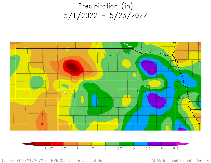
The cumulative impacts of the rainfall events that have been reported during the month of May can be found in Figure 1. It should be noted that this figure doesn’t include the precipitation (0.25-0.75 inches) that fell across the western half of the Sandhill region on May 23 or the ongoing precipitation event (May 24) that is expected to bring 1-2 inches of moisture to the eastern two-thirds of the state. May precipitation totals are greater than two inches across the eastern two-thirds of the state and 1-2 inches across the western one-third of Nebraska. Precipitation has exceeded four inches in two distinct pockets — one just northwest of the Norfolk area and the second spanning Seward, York, Fillmore and Saline counties.
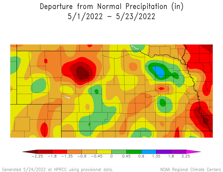
Even with the precipitation events that have been received across the state during the month of May, very few areas are showing surplus precipitation for the month. A small pocket of one inch moisture surpluses for the month of May can be found just northwest of Norfolk in Figure 2. The remaining surplus moisture pockets are generally less than 0.50 inches scattered around eastern Nebraska. However, May precipitation deficits are widespread across western Nebraska and exceed one inch across the northeastern Panhandle eastward across the western half of the northern Sandhill region. If the ongoing precipitation forecast for the event (May 24) currently underway verifies, the eastern half of Nebraska will have received surplus moisture this month and this area may push westward depending on how expansive the precipitation shield is with this ongoing event.
Current Crop Conditions
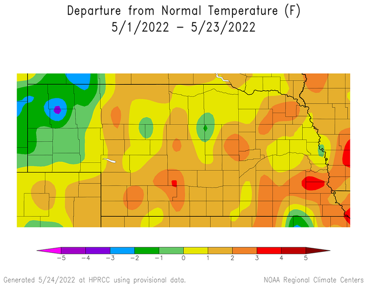
Warm season crop planting has been progressing at a slower pace than average this month according to Nebraska Agricultural Statistics Service (NASS), primarily due to colder than normal temperatures during the first 10 days of May. Although Figure 3 indicates that areas east of the Panhandle have experienced above-normal temperature anomalies of 1-3°F this month, most of this warmth has developed during the past 10 days. Below-normal May temperature anomalies of 1-3°F are concentrated across the northern Panhandle but are close to normal across the southern half of the region. At this point in time, crop development is behind normal due to the slower than normal planting pace and not because of below-normal air temperatures slowing crop development.
Corn and soybean planting really picked up steam the past two weeks according to NASS. As of May 22, corn planting was 85% complete and soybean planting reached 72% complete. Two weeks ago, corn planting was estimated at 39% complete, with soybeans at 28% complete. This means that 46% of the state corn crop and 44% of the soybean crop has been seeded over the past 14 days. On April 24, NASS reported that 10% of the state corn crop and 3% of the soybean crop had been planted. Therefore, in the two weeks after the final April crop progress report, 29% of the corn crop and 25% of the soybean crop was seeded.
In addition, NASS reports that as of May 22, 48% of the corn and 27% of the soybean crop had emerged. Last year 58% of the corn crop and 40% of the soybean crop had emerged at this time, which compares to the five-year average of 56% of the corn crop and 30% of the soybean crop.
Even with the recent uptick in moisture during May, it has not been able to significantly decrease the precipitation deficits that have developed due to the lack of widespread moisture from last November through the middle of this April. Figure 4 shows that a large area of southwest, south-central, central and northeast Nebraska have cumulative precipitation deficits since last October of 4.50–6.00 inches of moisture.

Depending on rainfall from the system currently impacting the state, central and northeast Nebraska stands a reasonable chance of seeing these deficits shrink at least one inch over the next couple of days. However, in order to completely reduce these long-term deficits before the end of June, these same areas will require 125-200% of normal June precipitation. Southwest Nebraska will require 175-200% of normal June normal moisture to eliminate these long-term deficits, while areas north and east of Norfolk will need 125-150% of normal moisture to eliminate long-term precipitation deficits.
Pasture conditions have responded favorably to the recent uptick in precipitation this month according to NASS. At the beginning of May, pastures were rated 47% very poor, 26% poor, 21% fair, 6% good and 0% excellent. As of May 22, NASS indicates that 16% of pastures were rated very poor, 23% poor, 34% fair, 26% good and 1% excellent. During the past three weeks, the very poor rating decreased 31 percentage points and the poor rating decreased 3 percentage points. There were rating improvements for the fair, good and excellent categories which increased 13, 20 and five percentage points, respectively. Since pastures appear to respond quickly to short-term moisture events, improvements that have been reported this month could rapidly deteriorate with below-normal moisture due to the lack of subsoil moisture recharge that occurred from last November through early April of this year.
Soil moisture survey data through May 22 indicates that there have been improvements due to recent precipitation events according to NASS, but dry conditions from November through mid-April are still playing a role in their topsoil and subsoil moisture estimates. As of May 22, topsoil moisture was rated 12% very short, 31% short, 55% adequate and 2% surplus. Subsoil moisture was rated 19% very short, 40% short, 40% adequate and 1% surplus. One month ago, topsoil was rated 45% very short, 37% short, 18% adequate and 0% surplus. Subsoil moisture was rated 40% very short, 44% short, 16% adequate and 0% surplus. Therefore, the increase in precipitation over the past month has led to an average improvement of one category for topsoil and subsoil moisture ratings. The largest improvement seen in the NASS soil moisture data over the past month was 75% reduction for topsoil moisture and 50% reduction of subsoil moisture rated very short.
Even with the recent uptick in moisture, the condition of the winter wheat crop continues to reflect the absence of widespread above-normal moisture during May and the poor soil moisture recharge dating back to last fall. Although recent precipitation has been welcomed, it has been insufficient in providing a buffer for short duration (less than 10 days) crop moisture needs.
As of May 22, NASS indicates 22% of wheat crop is rated very poor, 21% poor, 28% fair, 25% good and 6% excellent. One month ago, NASS indicated that 14% of the wheat crop was rated very poor, 18% poor, 44% fair, 21% good and 3% excellent. Given that low temperatures across the Panhandle region ranged from the low to upper 20s, it is likely that freeze injury occurred to the wheat crop which was at 10% headed. It is likely that most of the freeze damage issues will be reflected in next week’s NASS crop progress report as it may take several days for the full extent of impacts of this event to be known.
Current Weather Outlook
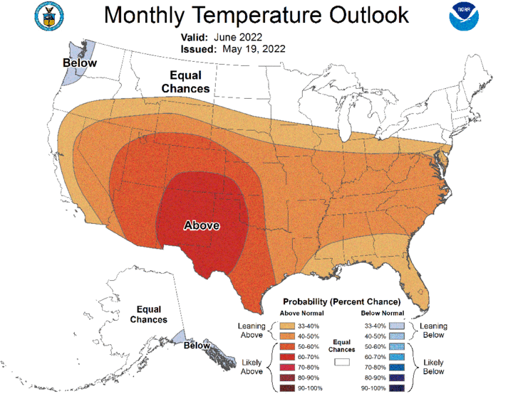
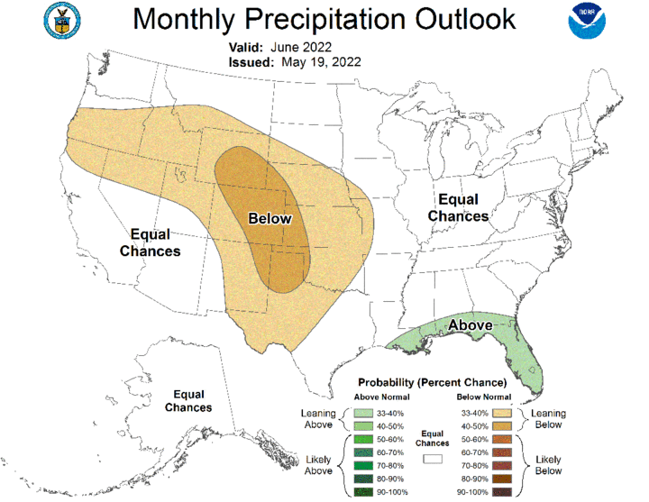
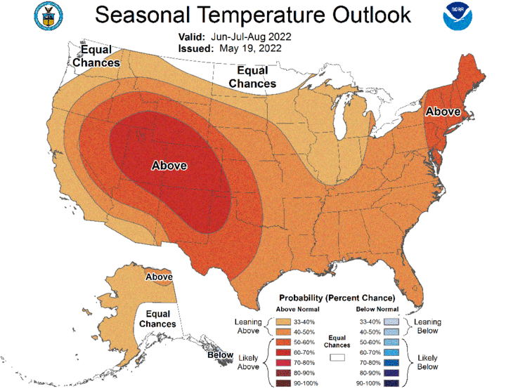
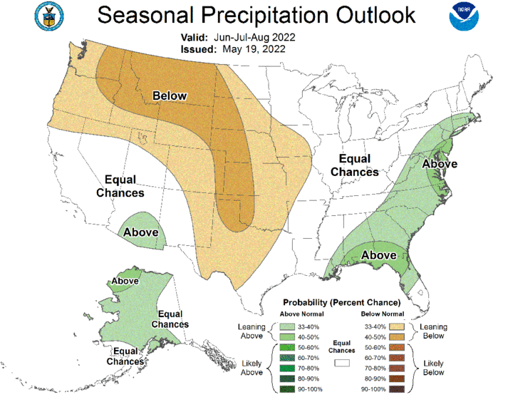
On May 19, the Climate Prediction Center (CPC) released their preliminary June outlook for temperatures and precipitation (Figures 5 and 6), along with their seasonal outlooks. Figures 7 (temperature) and 8 (precipitation) are for the summer growing period (June–August). In brief, CPC is indicating below-normal precipitation and above-normal temperatures are favored across Nebraska, with the highest probabilities assigned to the western fourth of Nebraska. In addition, the June – August temperature and precipitation outlooks increase probability levels in comparison to the June outlook across eastern Nebraska. To me, this would indicate that CPC is placing more emphasis on below-normal moisture during the second half of the summer for eastern Nebraska and western Iowa.
Although CPC is indicating warmer and drier-than-normal conditions across Nebraska this summer, the GFS model indicates that there will be several precipitation opportunities and air temperatures will go through distinct warm and cool periods over the next 16 days. The upper air trough currently impacting the central Plains will shift toward the Great Lakes during the second half of the week, which would allow an upper air ridge to build over Nebraska through the Memorial Day weekend.
Another strong upper air trough over the western third of the United States will begin to move northeast and lift this tough into the northern Plains by June 5. This trough is then projected to move toward the western Great Lakes and intensify, before drifting southwest toward southern Minnesota and northern Iowa May 8-9. If the GFS forecast verifies, there may be enough cold air with the June 8-9 upper air trough to bring a frost/freeze risk to parts of Minnesota, Wisconsin and Michigan.
The GFS model currently indicates that the upper air trough over the western United States will begin to move east-northeast through the Memorial Day weekend. Several waves of energy are projected to pivot around this trough and bring daily rounds of showers and thunderstorms to the northern Plains. Currently, the northern third of Nebraska has the best opportunity to see measurable moisture May 29-31, while the best chances for southern Nebraska appear to be June 1. At this point in time, the GFS model indicates that the eastern half of southern Nebraska is in an area favored for severe thunderstorm development. High temperatures during the period should range from the upper 70s to upper 80s May 27-31, cooling into the lower 70s to lower 80s June 1-5.
The upper air trough forecast to cross the northern half of the High Plains region through the Memorial Day weekend is forecast to move toward the western Great Lakes and allow high pressure to build over the central Plains June 2-5. The GFS model then takes the Great Lakes low and moves it southwest toward southern Minnesota and northern Iowa. The southwest movement of this upper air trough is unusual, but not unprecedented.
It also is a major contributor to the next major precipitation event forecast for Nebraska. According to the GFS model, as this trough moves southwest, energy will rotate around the trough and bring widespread precipitation to South Dakota and Nebraska June 5-6 and lighter amounts June 9 to the eastern half of the state. If the trough does develop as currently forecast, high temperatures June 6-9 will struggle to reach the 70°F mark. Northeast and north-central Nebraska may not breach 60°F, especially June 8-9.
