Weather Review
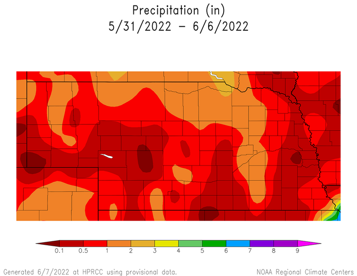
Weekly precipitation totals (May 30–June 5) exceeded two inches in pockets across the northern half of the Panhandle, as well as central and northeast Nebraska. According to NERain observers, every reporting location across the northern third of Nebraska west of Norfolk received at least one inch of moisture.
Weekly rainfall totals of 0.50-1.00 inches were observed across the southern half of the Panhandle, western half of southwest Nebraska, central Nebraska from Broken Bow to Central City and southeast Nebraska from Pawnee City northeast through Nebraska City. Unfortunately, a large area south of I-80 from Minden to Lincoln received nothing up to a quarter inch of moisture. Additional pockets of a quarter inch or less of moisture were reported to the north-northwest of Lexington, Kearney and Grand Island in central Nebraska, as well as between Lincoln and West Point.
The most active periods of measurable moisture occurred May 30-31 and June 4-5 as two distinctly different upper air troughs moved from the western United States into the northern High Plains and south-central Canada. Figure 1 shows the cumulative impacts of these precipitation events.
The May 30-31 precipitation event resulted in widespread rainfall across the Panhandle and north-central Nebraska, while the June 4-5 event was most concentrated across the southwest and northeast corners of the state. Figure 1 doesn’t include the precipitation from strong thunderstorm activity scattered across the state that fell after 8 a.m. June 6. This moisture will be included in next week’s agricultural weather update.
With two upper air troughs crossing the central and northern High Plains this past week, cool Canadian air was drawn southward, resulting in below-normal temperatures across Nebraska (Figure 2). Average temperatures were 4-6°F below normal from the northeastern Panhandle eastward through northeastern Nebraska.
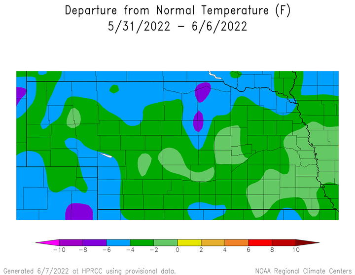
Additional smaller pockets of similar anomalies were observed across the southwest and southeastern Panhandle, the western half of southwest Nebraska and a smaller area centered on Red Cloud.
The weakest below-normal average temperature anomalies reported from May 31–June 6 were located across east-central Nebraska, as well as small pockets in central and west-central areas of the state with anomalies up to 2°F below normal. All remaining areas of the state reported average temperature anomalies of 2-4°F below normal.
Concern is mounting in regard to these cool temperatures slowing down crop development, but if the current outlooks come to fruition, then it is likely that above-normal temperatures forecast June 10-20 will temporarily ease these concerns.
Current Crop Conditions
The pockets of accumulated weekly precipitation values exceeding two inches across the northern Panhandle, northeast and central Nebraska likely contributed to modest improvements to pasture and soil moisture conditions on a statewide basis. In addition, almost every location across the Sandhill region reported at least one inch of moisture according to NERain observers, as well as pockets of southwest, central, southeast and east-central Nebraska. Unfortunately, some of these improvements were offset by the lack of moisture with less than 0.25 inches observed south of I-80 from Minden to Beatrice.
The Nebraska Agricultural Statistics Service (NASS) indicates that topsoil moisture conditions ending on June 5 were rated 11% very short, 25% short, 62% adequate and 2% surplus. There was a one-percentage point improvement in the very short and short categories, while the surplus category decreased one percentage point. This contributed to a three-percentage point increase in the adequate category.
Subsoil moisture was rated 16% very short, 32% short, 51% adequate and 1% surplus. There was a one-percentage point decline in the very short category from the previous week and a five-percentage point decline in the short category. The adequate category increased five percentage points, while the surplus category declined one percentage point.
There was a more significant change to pasture conditions from last week's rain events according to NASS. Pastures as of June 5 were rated 10% very poor, 19% poor, 43% fair, 26% good and 2% excellent. The very poor category shrank five percentage points, while the poor category declined four percentage points. There was only a one-percentage point decline in the fair category, but the good category expanded by eight percentage points. The good and excellent categories represent 28% of Nebraska pastures as of June 5, which is still low, but considerably higher than the 20% estimated for pastures with similar ratings on May 29.
Corn planting is considered to be statistically complete according to NASS and emergence is estimated to be at 88% as of June 5. Last year, 93% was emerged by this date, which compares to the five-year average of 89%. The first corn condition estimate for 2022 was released this week and NASS estimates (based upon surveys) that 1% is rated very poor, 4% poor, 20% fair, 62% good and 13% excellent.
Soybean planted is estimated to be 88% as of June 5, compared to 97% last year and the five-year average of 90 percent. Emergence was estimated to be 75%, compared to 82% last year and the five-year average of 71%. The first soybean condition estimate for 2022 indicates that 1% is rated very poor, 4% poor, 16% fair, 67% good and 12% excellent.
Sorghum planting increased 20 percentage points from May 29 to June 5. NASS estimates that 75% of the crop has been seeded, compared to 69% last year and the five-year average of 72%. No emergence information for sorghum was given by NASS, but the first condition estimates were available. NASS estimates that 0% of the crop is rated very poor, 4% poor, 24% fair, 71% good and 1% is excellent.
The winter wheat crop is entering the final stretches of its growing season and NASS estimates that 74% of the crop was headed as of June 5, which compares to 75% last year and the five-year average of 73%. Crop conditions for wheat have consistently shown the impacts of drought conditions dating back to late last summer in every crop progress report released by NASS in 2022. This week is no different with 20% of the crop rated very poor, 17% poor, 34% poor, 24% good and 5% excellent. According to extension educators, most of the good and excellent wheat conditions are located across the eastern third of Nebraska.
Current Weather Outlook
The most current version of the GFS weather model issued the morning of June 6 indicates that the vast majority of moisture associated with frontal boundaries working through the central High Plains will occur through the remainder of this week before atmospheric ridging begins to develop across the central third of the United States leading to an extended period favoring drier and warmer than normal weather. Currently, an upper air low is situated over central Manitoba and is forecast to deepen as it slides eastward through the remainder of this week. This will allow an atmospheric ridge of high pressure to build east and north from the southwestern United States in response to a deep upper air trough moving into the western United States. At present, the GFS model indicates that this ridge will dominate areas east of the Rockies June 13-20.
Several additional rounds of thunderstorms are predicted for the central United States over the next few days as the upper air low currently over Manitoba slides eastward. Severe thunderstorms are predicted to develop during the late afternoon hours of June 7 through the first half of June 8. The most favorable area for convection lies east of the Panhandle, with central and south-central Nebraska having a moderate risk of widespread severe thunderstorm development. Another wave is forecast to move southeast on the backside of the Manitoba low and produce precipitation across the eastern half of the state from the evening of June 9 through the morning of June 10. High temperatures are forecast to range from the low to mid-70s north to the upper 70s to low 80s east. Figure 3 is the forecast moisture expected from June 7 through 7 a.m. June 14, with most of this moisture occurring in the first 48 hours.
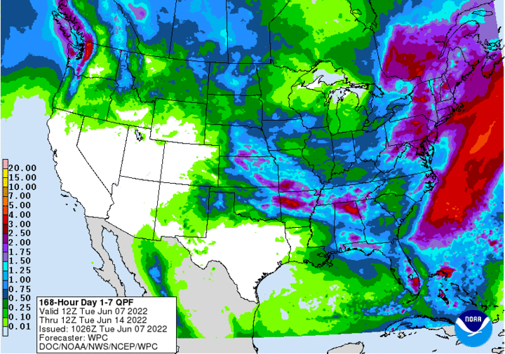
As the Manitoba upper air low slide east toward central Ontario, it will deepen and keep eastern Nebraska in a northwest flow aloft. Therefore, maximum temperatures will likely remain stuck in the 70s to low 80s through June 11, while western Nebraska begins to experience a warming trend due to atmospheric ridging expanding northeast from the southwestern U.S. desert region. The GFS model indicates that two weak lobes of energy may impact eastern Nebraska June 12-13 as the upper air ridge gradually expands eastward into Iowa. High temperature should reach the upper 80s to middle 90s across western Nebraska June 10-11, and June 12-13 across eastern Nebraska.
From June 14 through at least June 19, the GFS model forecast is for a large upper air ridge to dominate the central and southern High Plains. High temperatures should persistently be in the 90s across the state, with the best chances of seeing 100°F or greater temperatures June 16-18.
This is all dependent on an accurate forecast in regard to the movement of the upper air trough that is forecast to lie over the western third of the United States. The GFS model hints that this trough will begin to eject energy toward the central and northern High Plains region June 20-23 (end of model forecast period), which would bring high temperatures back into the 80s and increase precipitation chances statewide as the western upper air trough moves toward south-central Canada.
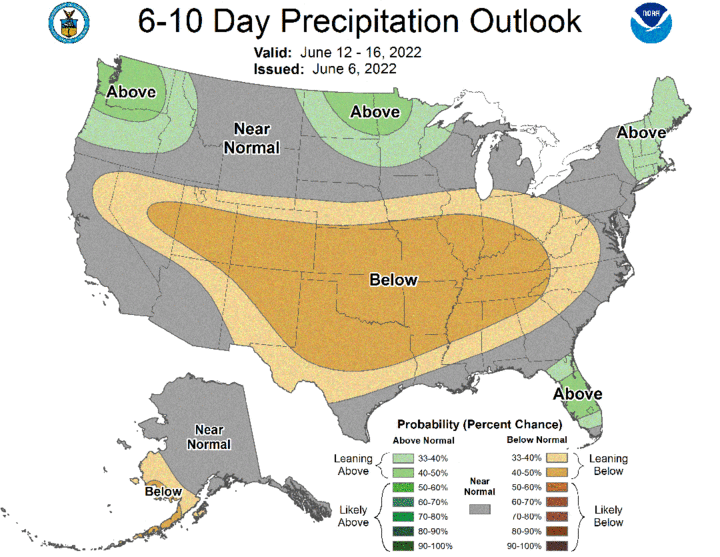
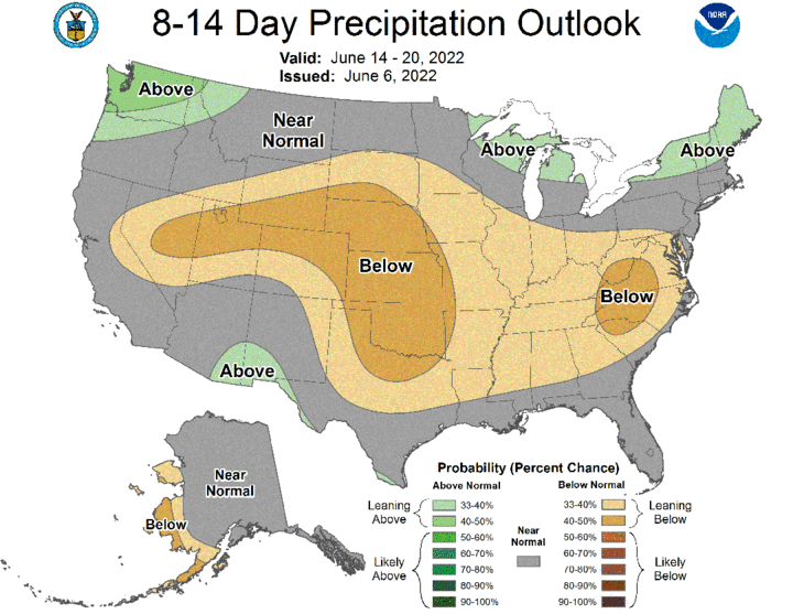
Before that happens, below-normal moisture is expected to dominate a large area of the central and southern Plains as depicted in Figures 4 and 5. Thus, irrigation will likely increase dramatically during this period and some moderate heat stress may occur to livestock depending on whether dew point values remain elevated in combination with light wind speeds.
