Weather Review
Temperatures across the state during the past week (June 20-26) were influenced by a battle between two competing air masses. An upper air slowly moved across the northern half of the Rockies and pushed the northern extent of an upper air ridge centered over Texas south of state. As the upper air low moved into the western Great Lakes, cool Canadian air filtered southward to provide a break from the heat and humidity this past weekend.
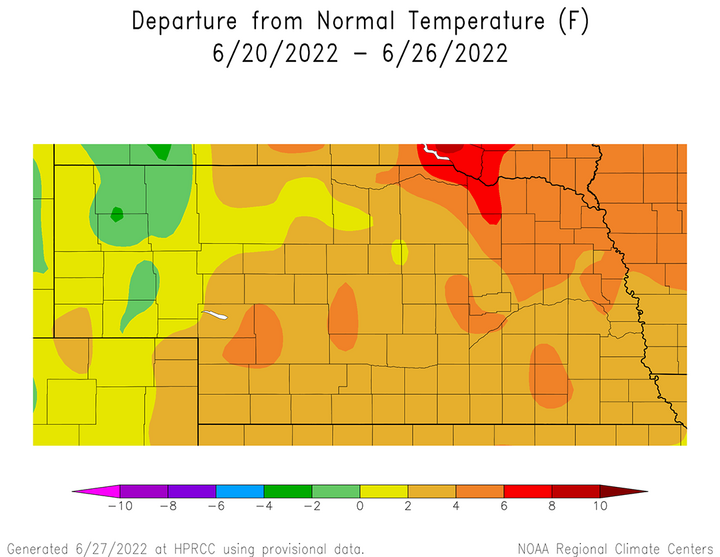
Average temperature anomalies were above normal east of the Panhandle (Figure 1), peaking at 6-8°F above normal across the eastern Niobrara river valley in northeast Nebraska. The remainder of northeast Nebraska averaged 4-6°F above normal, with anomalies of 2-4°F above normal for areas east of the Panhandle and south of northeast Nebraska. Average temperatures were normal to 2°F above normal across the southern half of the Panhandle and normal to 2°F below normal across the northern half of the region.
Average temperature anomalies do not tell the entire story as there were significant location differences when comparing where maximum and minimum temperature anomalies occurred this past week. According to Figure 2, average maximum temperatures were 6-10°F above normal across the northeast corner of the state, the southwestern Sandhill region and the South Dakota border region of north-central Nebraska. Anomalies were up to 4°F above normal across south-central, east-central, and southeast Nebraska, while the remainder of the state saw average maximum temperature anomalies of 4-6°F above normal.


The highest daily maximum temperature recorded across the state ranged from 94°F to 102°F at airport locations across the state June 20-24, before dropping into the 80s this past weekend. Daily high temperatures are as follows: June 20 — 102°F (Wayne); June 21 — 96°F (Falls City); June 22 — 94°F (Chadron); June 23 — 100°F (Scottsbluff); June 24 — 98°F (Ogallala); June 25 — 87°F (Falls City); June 26 — 83°F (Grand Island, Norfolk, Tekamah).
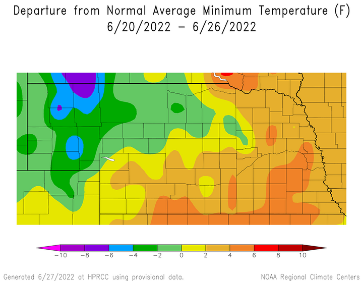
Figure 3 shows the average minimum temperature anomalies for this past week and most of the Panhandle was cooler than normal. Average minimum temperatures were normal to 4°F below normal across the southern half of the region and 4-8°F below normal across the northern half of the Panhandle. East of the Panhandle, minimum temperatures averaged normal to 4°F above normal, except for a swath from Fairbury to Fremont where anomalies were 4-6°F above normal.
The lowest daily minimum temperature recorded in the state at airport locations ranged from 39°F to 53°F, with every daily statewide low temperature observation occurring across the Panhandle. Daily low temperatures are as follows: June 20 — 52°F (Alliance); June 21— 39°F (Alliance); June 22 — 42°F (Gordon); June 23 — 48°F (Kimball); June 24 — 53°F (Sidney); June 25 — 51°F (Alliance, Gordon, Sidney); June 26 — 40°F (Chadron).
When maximum temperatures cool 15-20°F over a 24-hour period in the summer, it is accompanied by thunderstorm development. This did occur across extreme southern Nebraska the evening of June 23 through the morning of June 24 along the Nebraska–Kansas border. Unfortunately, most of the moisture fell across northern Kansas. Rainfall totals of 0.30 to 1.20 inches were reported across the southern half of counties from south-central through southeast Nebraska according to NERain observers. Additional development occurred June 25 in a narrow line from Benkelman to Columbus, which produced 0.25–0.75 inches of moisture.
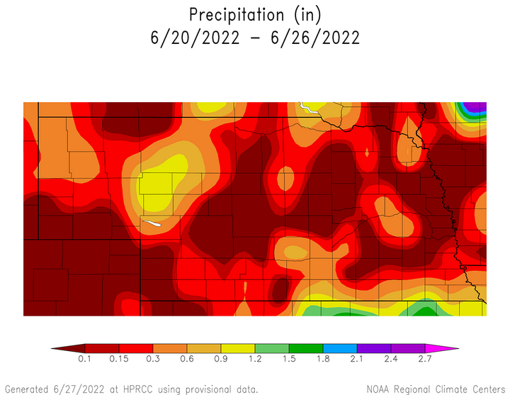
Figure 4 shows the accumulated rainfall for June 20-26 and excluding the June 24 and June 25 moisture events, precipitation was confined to very small pockets across the state. Daily precipitation reports from NERain observers indicate 0.25-0.36 inches fell across the northeastern Panhandle on June 20, as well as a very narrow strip of 0.65 to 1.40 inches of moisture west of McCook and east of Imperial. The northwest Panhandle received 0.35–0.70 inches of moisture on June 21, with less than 0.25 inches of moisture on June 22 across southeast Nebraska.


Crop Progress
Above-normal temperatures the past two weeks have led to rapid crop growth and increased crop water demand. Therefore, it is not surprising that the Nebraska Agricultural Statistics Service (NASS) reports that statewide soil moisture and crop condition estimates as of June 26 declined when compared to conditions a week earlier.
Topsoil moisture supplies as of June 26 were rated 20% very short, 37% short, 42% adequate and 1% surplus. There was a six-percentage point increase in the very short category and a seven-percentage point increase in the short category. Topsoil moisture rated adequate dropped 12 percentage points from the June 19 report. Subsoil moisture supplies as of June 26 were rated 21% very short, 35% short, 43% adequate and 1% surplus. There was a five-percentage point increase in the very short and short categories, while the adequate category dropped 10 percentage points from the June 19 report.
NASS indicates that corn on June 26 was rated 3% very poor, 9% poor, 24% fair, 51% good and 12% excellent. Compared to the June 19 report, the fair category increased four percentage points and the excellent category increased two percentage points. Both of these category changes came at the expense of corn rated good, which dropped seven percentage points from the previous week.
Soybeans as of June 26 were rated 4% very poor, 8% poor, 26% fair, 50% good and 12% excellent. There was no change in the percent of soybeans rated very poor or poor compared to the June 19 crop report. However, there was a six-percentage point increase in the fair category and a one-percentage point increase in the excellent category, which led to a seven-percentage point decline in the good category.
The lack of widespread moisture across western Nebraska, coupled with maximum temperatures in the middle 90s to low 100s for the first two-thirds of last week led to additional declines in pasture and wheat ratings according to NASS. Pastures rated very poor to poor increased to 31%, an increase of 10 percentage points. Pastures rated good to excellent decreased 11 percentage points to 34%.
The winter wheat harvest is rapidly approaching and NASS reports that the crop continues to deteriorate from the lack of moisture and above-normal average temperatures this past week. NASS rates the wheat crop as of June 26 as 16% very poor, 19% poor, 44% fair, 19% good and 3% excellent. Compared to the June 19 report, the fair category increased three percentage points, while the good category declined an equal amount.
Current Weather Outlook
Warm season crops will begin to enter their reproductive phases during the upcoming month, so precipitation events will become critical regarding fall yield prospects. This is especially important given the recent stretch of above-normal average temperatures, limited coverage of recent precipitation events and deteriorating soil moisture supplies.
According to the GFS model run the morning of June 28, monsoon moisture and another upper air trough moving across the northern third of the United States are forecast to provide several opportunities for precipitation across the Central Plains over the next 10 days. The major issue will be where the precipitation develops because the GFS model has not consistently kept precipitation focused on any particular area within Nebraska.
The jet stream pattern from June 28 through July 2 is forecast by the GFS model to move the upper air trough currently situated over the Pacific Northwest to the western Great Lakes. This would flatten the top of the upper air ridge that currently extends from Texas northward through Nebraska. Temperatures will warm into the upper 80s to middle 90s June 28, low to upper 90s June 29 and upper 90s to low 100s June 30. Highs are forecast to cool back into the middle 80s to low 90s July 1-2.
The best opportunities for moisture during this stretch should occur from the afternoon of June 30 through the evening of July 2. According to the GFS model, the southern half of the state has the highest precipitation chances though July 1, with the northern half of the state having better odds on July 2. Rainfall amounts are forecast to be in the 0.25– to 1.50-inch range through July 2, with the heaviest totals forecast for the southern third of the state.
A warming trend is forecast by the GFS model July 3-8 as the upper air trough forecast for the Great Lakes region weakens and the southern Plains ridge builds northward. High temperatures are forecast to return 90s, potentially upper 90s to low 100s July 7-8. Although the GFS model indicates daily chances for thunderstorm activity, the highest moisture probabilities are across the northern half of the state July 4 and the eastern half of the state July 7-8. The GFS model does indicate moisture chances for the western half of Nebraska during this period, but it hints at less widespread coverage.
More uncertainty lies with the GFS models forecast for the final six days of its current forecast period (July 9-14). The upper air ridge is being forecast to build westward toward the southern Great Basin July 8-10 which places Nebraska on is eastern edge. If this were to verify, the western half of the state would likely see 100-105°F high temperatures, with middle to upper 90s across eastern Nebraska. Precipitation chances would be slim during this stretch, as moisture chances would shift north and east of the Central Plains.
If the upper air ridge remains in place July 11-14, hot and dry conditions would continue for Nebraska. However, the current GFS model run breaks the ridge down by moving an upper air trough from the Pacific Northwest into the western Great Lakes. This flattens out the upper air ridge and allows high temperatures to cool back into the 80s across Nebraska. Pieces of energy are forecast to rotate through the Central Plains, giving daily chances of thunderstorm development from northern Kansas through the southern half of South Dakota.
