Weather Review
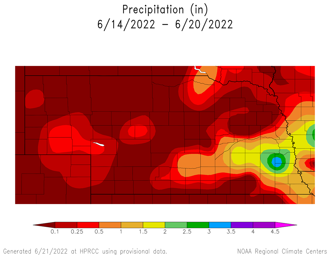
Precipitation during the past week (June 14-20) was most concentrated north and south of the I-80 corridor from Kearney eastward to the Iowa border as severe thunderstorms developed the evening of June 13 and continued through the pre-dawn hours of June 14. Precipitation reports indicate that 0.50 to 1.00 inches of moisture fell within a 20-mile corridor north and south of I-80 from Kearney to Grand Island. This area expanded as it headed east and precipitation totals increased into the 1.00 to 3.50 inch range from Aurora to the Iowa border (Figure 1).
Unfortunately, a significant line of hail and high winds were observed from York to Greenwood resulting in severe crop damage. The Storm Prediction Center preliminary data for this event indicates that storm spotters submitted one tornado, 29 hail and 23 wind reports during this outbreak. Hail size varied from quarter to hen size, while wind gusts ranged from 58 to 90 miles per hour.
This thunderstorm activity formed on the boundary between an upper air low crossing the northern Plains and a dome of high pressure situated over the southern High Plains. It also gave the state a very brief respite from hot and humid conditions that developed June 12-13. High temperatures reached 109°F at McCook on June 13 before the cooler and drier air mass lowered maximum temperatures across the state into the mid 80s to low 90s June 14-16. Hot and humid conditions returned to the state June 17-19 with high temperatures warming into the mid-90s to low 100s.
It should come as no surprise that average temperatures for the week were above normal when maximum temperatures exceed 95 multiple times compared to normal high temperatures that are in the upper 80s this time of the year. The cumulative impacts of this heat can be seen in Figure 2, which depicts average temperature anomalies of 6-12°F above normal June 14-20. West-central and southwest Nebraska had average temperature anomalies from 8°F to 12°F above normal, while the northern Panhandle and most of southeast Nebraska were 4-6°F above normal. The vast majority of the state ranged from 6-8°F above normal.
Maximum temperature anomalies for the June 14-20 period were 10-12°F above normal across west-central, southwest and northeast Nebraska. The northern Panhandle and southeast Nebraska maximum temperature anomalies were 4-6°F above normal, while the remainder of the state was 6-8°F above normal. At least one location in the state reached 100°F or higher on June 13, 17, 18 and 19. The hottest maximum temperature that was reported last week occurred on June 13 when the thermometer reached 109°F at McCook.


Current Crop Conditions
The Nebraska Agricultural Statistics Service (NASS) crop progress and condition report issued on June 21 indicates improvements and degradations depending on the subject analyzed. Above-normal temperatures and limited rainfall resulted in pasture and soil moisture declines during the past week. Winter wheat conditions declined, while sorghum and corn conditions improved.
With average temperatures running 6-12°F above normal and precipitation limited to pockets of east-central, southeast, northeast and western Nebraska, topsoil and subsoil supply ratings declined going into the final 10 days of June. NASS reports that topsoil conditions as of June 19 were rated 14% very short, 30% short, 54% adequate and 2% surplus. Compared to conditions on June 12, the very short category increased five percentage points and the short category increased six percentage points. These increases were at the expense of the adequate category, which dropped 11 percentage points.
Subsoil moisture conditions declined slightly according to NASS. As of June 19, subsoil moisture was rated 16% very short, 30% short, 53% adequate and 1% surplus. Only two categories showed changes compared to conditions on June 12. There was a three-percentage point increase in the very short category, which was offset by a three-percentage point decline in the adequate rating.
With hot and dry conditions widespread across the grassland areas of Nebraska this past week, it is no surprise that pasture ratings declined when compared to conditions on June 12. NASS reports that pastures are rated 10% very poor, 21% poor, 32% fair, 33% good and 4% excellent as of June 19. This represents a six-percentage point increase in the poor category, a one percentage point increase in the fair category, a six percentage point decrease in the good category and one percentage point decline in the excellent category.
Winter wheat statewide conditions declined as of June 19 due to the lack of widespread moisture coupled with above-normal temperatures across the western two-thirds of Nebraska. The winter wheat condition was rated 15% very poor, 19% poor, 41% fair, 22% good and 3% excellent according to NASS. Compared to conditions on June 12, the very poor category decreased four percentage points. The poor category increased one percentage point, while the fair category decreased seven percentage points and the good category decreased three percentage points.
According to NASS, the corn condition improved during the past week, as the good to excellent category increased four percentage points to 68%. As of June 19, corn was rated 3% very poor, 9% poor, 20% fair, 57% good and 11% excellent. There was no change in the very poor and poor categories from the previous week. However, the fair category decreased three percentage points, while the good category increased five percentage points and the excellent category decreased two percentage points.
NASS indicates improvement of the sorghum crop from the previous week and the crop is currently rated 1% very poor, 8% poor, 26% fair, 61% good and 4% excellent. The poor category declined four percentage points, while there was a six percentage point increase in the good category and one percentage point increase in the excellent category.
There was a one percentage point increase for soybeans rated good to excellent, which is 69% as of June 19 according to NASS. Soybeans are rated 4% very poor, 8% poor, 20% fair, 57% good and 11% excellent. The net change from the previous week is a one percentage point increase in the very poor and poor categories, a one percentage point decrease in the fair category and a one percentage point increase in the excellent category.
Current Weather Outlook
It does appear that the GFS model is trending toward cooler temperatures this weekend and possibly continuing into early July. This may have an impact on the Climate Prediction Center’s (CPC) preliminary July temperature and precipitation outlook issued June (Figure 4-5) which calls for above-normal temperatures and below-normal precipitation across Nebraska.
CPC cooled their preliminary outlooks issued the third Thursday of May and June when compared to the final (official) monthly outlooks issued the last day of these two months. Therefore, the upper air pattern and near-term weather model forecasts play a large role in CPC’s monthly outlook. At present, the GFS model is running about 5-10°F cooler entering July than it was last Thursday when the preliminary July outlook was issued.
The most current GFS model run issued the morning of June 22 indicates that a brief return to hot and humid conditions June 23-24 is likely as the upper air ridge pushes northward from the southern High Plains. As it does, thunderstorms are forecast to develop on the northern edge of this upper air ridge and tap monsoon moisture moving northward through the southern half of the Rockies. At the same time, an upper air trough will be crossing the northern Rockies, which is expected to create a convergence zone across the southern half of the state.
High temperatures are forecast to move into the upper 80s to mid 90s June 23, warming into the low 90s to low 100s June 24. A cold front is forecast to slide through the state during the late afternoon of June 24 into the first half of June 25. It is likely that severe thunderstorms will develop, with the highest risk currently assigned to the central third of the state. As the upper air trough moves across the northern Plains, a much cooler air mass is forecast for the northern and central High Plains June 25-27. High temperatures across the state should remain in the 80s, possibly the upper 70s across the northern third of the state.
The upper air ridge is then forecast to expand northward June 28-30, which should result in high temperatures returning to the upper 80s northeast to mid-90s southwest. Isolated thunderstorms could develop across the western third of the state during peak heating hours if monsoon moisture returns to the southern and central Rockies.


Another upper air trough is forecast to move across the northern Plains to start the month of July, then deepen as it moves toward the Great Lakes. The GFS model then keeps this upper air trough anchored over the Great Lakes and northern High Plains through July 8 (end of model forecast period). The upper air ridge is forecast to be pushed south and west, which would help increase monsoon moisture transport into the southern half of the Rockies.
This scenario would put Nebraska between the two competing air masses and create a northwest flow aloft. Therefore, the northeast fourth of the state would be favored for the coolest daytime highs and southwest Nebraska would receive the warmest temperatures. High temperatures are currently forecast to range from the mid-80s northeast to mid-90s southwest July 1-8.
With a northwest flow aloft and monsoon moisture streaming northward through the southern and central Rockies, the GFS model aggressively points toward daily rounds of thunderstorm activity moving southeast out of Montana and Wyoming. Currently, the highest precipitation probabilities and severe weather potential are forecast for July 2, 5, 7 and 8. If this forecast verifies, western Nebraska will have multiple chances for widespread precipitation that would slow drought expansion and intensification heading into the reproductive stage for warm season crops.
