Weather Review
This past week (June 6-12) was active in regards to severe weather reports, with the only non-active severe weather days being June 8 and June 10. The preliminary storm report data base archived at the Storm Prediction Center (SPC) indicates that there were six tornado reports, 140 hail reports and 95 wind reports. The most active day of this period was June 7 when 87 hail reports and 85 wind reports were issued by storm spotters according to SPC. Extension educators with the University of Nebraska reported major crop, building and center pivot damage across the northeastern quarter of Nebraska with this event. Additional severe hail damage was reported from York southeastward through southern Gage county on June 11, when thunderstorms produced widespread hail from golf ball to baseball size across the southern half of Gage county.
After a cool start to the week, the upper air ridge situated over the southern High Plains and southeastern United States was pushed west and northward in response to an upper air trough, which crossed the northern Plains and strengthened it reached the Great Lakes region. High temperatures broke the 90°F mark across the Panhandle on June 8, then expanded into eastern Nebraska by June 10. As the heat expanded eastward, the western third of Nebraska saw high temperatures approach the century mark. It wasn’t until June 12 that eastern Nebraska experienced widespread highs in the upper 90s to low 100s.
Except for the eastern half of north-central and a small pocket of east-central Nebraska, average temperature anomalies from June 7 through June 13 were above normal (Figure 1). The southern third of the Panhandle through west-central Nebraska recorded average temperature anomalies of 4-6°F above normal. Average temperature anomalies of 2–4°F above normal were observed south and west of a line from the northwestern Panhandle trough the south-central Sandhill region. North and east of this area, average temperature anomalies were up to 2°F above normal, except for the northeast corner of the state where anomalies were up to 2°F below normal.
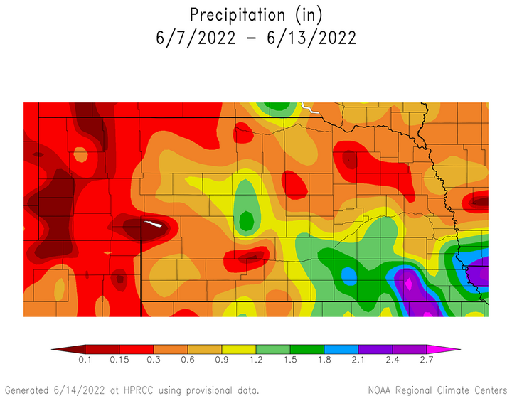
Weekly precipitation (June 7-12) totals exceeded 1.20 inches in an extensive area south of the I-80 corridor from eastern Buffalo through southern half of Saunders County (Figure 2). This same area extended north of I-80 and included most of Hall, Hamilton, York, eastern Polk, western Butler and western Seward counties. Rainfall totals of 1.50–3.00 were most concentrated from Grand Island trough southern Gage County and along the Missouri river east of a line from Gretna to Falls City. Less than 0.30 inches of moisture were reported across most of the Panhandle, along with pockets of west-central, north-central and northeastern Nebraska.


Current Crop Conditions
All three of the major warm season crops (corn, soybean, sorghum) showed condition declines when compared to the previous week according to the Nebraska Agricultural Statistics Service (NASS). Pasture and soil moisture ratings improved slightly, which indicates that the major contributor to the warm season crop condition declines was the extensive storm damage that occurred with the severe weather outbreaks on June 7 and 11.
Topsoil and subsoil moisture conditions improved slightly for the week ending on June 12. According to NASS, topsoil moisture was rated 9% very short, 24% short, 65% adequate and 2% surplus. Subsoil moisture was rated 13% very short, 30% short, 56% adequate and 1% surplus. Topsoil moisture rated very short to short decreased three percentage points, while the adequate rating increased the same amount. Subsoil moisture rated poor to very poor decreased five percentage points, while the adequate rating increased the same amount.
Pasture ratings also experienced improvement according to NASS. As of June 12, pastures were rated 10% very poor, 15% poor, 31% fair, 39% good and 5% excellent. The very poor rating was unchanged from the previous week, but the poor category declined four percentage points and the fair category declined 12 percentage points. The good and excellent categories had strong improvements of 13 and three percentage points, respectively.
Corn emergence across Nebraska was estimated to be 92% as of June 12 according to NASS. The crop was rated 3% very poor, 9% poor, 23% fair, 52% good and 13% excellent. The net change from conditions as of June 5 was a two-percentage point increase in the very poor category, a five-percentage point increase in the poor category, a three-percentage point increase in the fair category, a 10-percentage point drop in the good category and no change in the excellent category.
Soybean emergence was estimated to be 90% as of June 12 according to NASS. The crop was rated 3% very poor, 7% poor, 21% fair, 57% good and 12% excellent. Compared to June 5 conditions, the very poor category increased two percentage points, the poor category increased three percentage points and the fair category increased five percentage points. This led to a 10-percentage point decline in the good rating, while the excellent rating remained unchanged.
Sorghum planting reached 90% as of June 12 according to NASS, which compares to 85% last year and the five-year average of 86%. The crop was rated 1% very poor, 11% poor, 30% fair, 55% good and 3% excellent. Compared to the June 5 estimate, the very poor category increased 1 percentage point, the poor category increased 7 percentage points, the fair category increased 6 percentage points, the good category decreased 16 percentage points and the excellent category increased 2 percentage points.
Winter wheat as of July 12 was 87% headed, compared to 91% last year and the five-year average. Crop conditions were essentially unchanged from the previous week and the crop was rated 19% very poor, 18% poor, 34% fair, 25% good and 4% excellent.

Current Weather Outlook
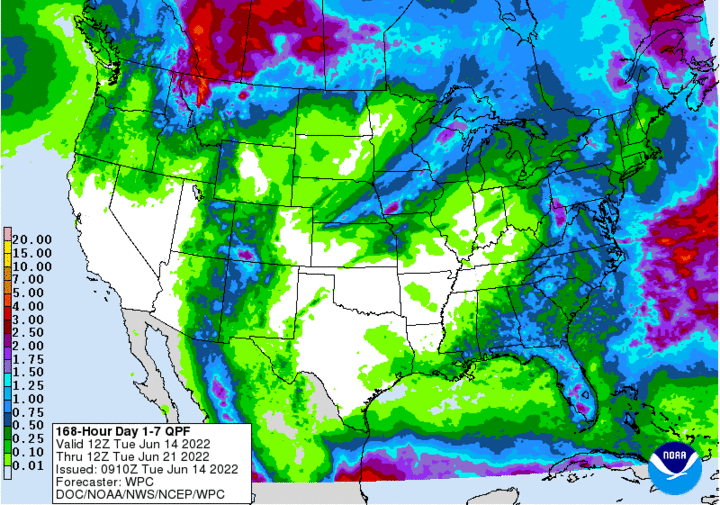
The GFS weather model issued the morning of June 14 indicates that the recent mini heat wave will return to the central Plains beginning June 17 and continue through at least June 22. This will occur as the upper air trough currently moving across the northern Plains shifts into the Great Lakes region. Most of the precipitation that is forecast from June 14-21 is expected to occur during the first next 24 hours in response to a surface cold front moving through the eastern half of Nebraska (Figure 3).
There is a slight chance for scattered showers and thunderstorms across extreme eastern Nebraska on June 16 and June 17 as energy rotates along the backside of the Great Lakes upper air trough. Current model output indicates that if precipitation materializes, general coverage amounts are expected to be less that 0.25 inches, with locally higher amounts if thunderstorms do develop. The GFS model indicates that the majority of moisture with these events will remain to our east across Iowa and Minnesota.
High temperatures are forecast to being in the 80s to low 90s June 15, then warm into the upper 80s to middle 90s June 16. From June 17 through June 21, widespread middle 90s to low 100s are forecast statewide, with the warmest temperatures forecast for the southern half of the state. An upper air trough will begin to slowly move east from the central and northern Rocky Mountains by June 22, which may bring a slight cool down to the northwestern Panhandle, but hot conditions will continue for the remainder of the state.
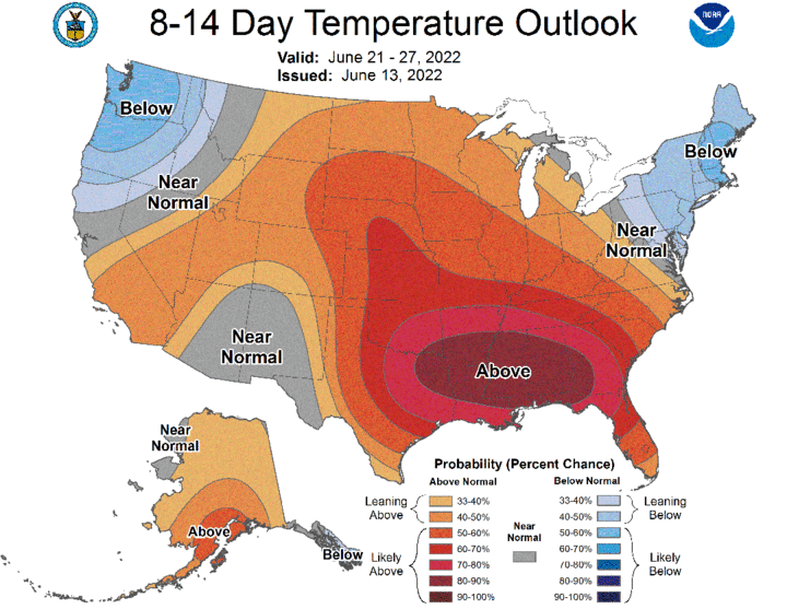
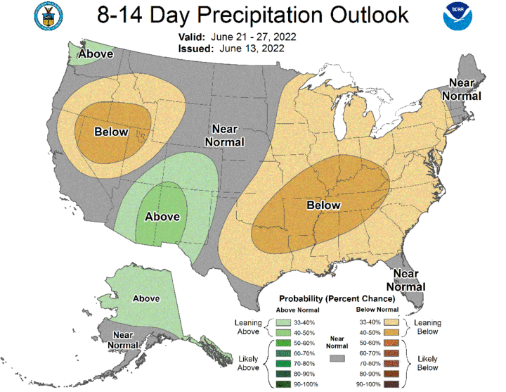
From June 23-30, there is considerable uncertainty regarding air temperatures and precipitation chances across the state. The Climate Prediction Center (CPC) 8-14 day outlook for June 21-30 indicates above-normal temperatures are favored with equal chances of above-normal, normal or below-normal precipitation (Figures 4 and 5). Since this outlook was issued by CPC yesterday afternoon, there has been a reduction in the precipitation forecast and an increase to high temperatures across the central Plains according to the GFS weather model.


Instead of an extended period of daily precipitation chances from June 22-27 as weather models suggest for the past five days, the GFS model now indicates the best precipitation chances will be June 26 as a trough moves across the northern Plains. A slight cool down is forecast statewide June 23, with the best chances for moisture occurring across the northern tier of Nebraska counties. Hot temperatures are forecast to return June 24-25, before temperatures cool back into the 80s June 26. From June 27-30, the upper air ridge is forecast to expand north and bring a return to maximum temperatures in the 95-105°F range. Thus, with such a large flip in model outcomes, considerable uncertainty exists in regard to temperatures and precipitation the last seven days of June.
