Weather Review
Once again, this past week’s weather was dominated by a battle between competing air masses, an upper air ridge centered over the southern Plains and an upper air trough migrating across the northern Plains. This time the air mass behind the upper air trough lacked atmospheric moisture and the return of hot temperatures with very windy conditions June 28-30 created high evapotranspiration conditions for growing crops. With subsoil moisture levels depleting, crop stress was reported for across northeast Nebraska dryland acres, as well as irrigated fields impacted by structural damage of center pivot systems impacted by severe winds from early June thunderstorm activity.
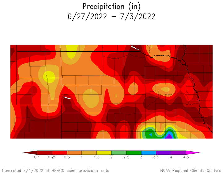
Figure 1 shows the cumulative precipitation that fell from the morning of June 26 through the morning of July 3. Precipitation that fell after 9 a.m. Central and Mountain Daylight Savings Time is not included in this analysis and will be reflected in next week’s edition. The vast majority of moisture reported during this period occurred from the morning of June 30 through the morning of July 1 in response to an upper air trough moving across the northern Plains.

Precipitation reports from NERain observers indicate that most concentrated area of moisture fell along and north of the I-80 corridor from west-central through east-central Nebraska. Precipitation ranged from 0.25 to 1.50 inches in this area, with the highest totals occurring where thunderstorm activity was more pronounced. Additional areas receiving moisture included the northern Panhandle and a small area of south-central and southeast Nebraska immediately adjacent to the Kansas border. The greatest 24-hour precipitation total reported last week occurred in the Superior area with 4.30 inches.
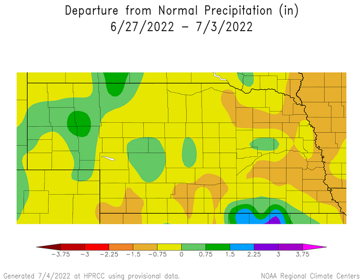
On the flip side, the northeastern Sandhill region, northeast Nebraska and southwestern areas to the west of McCook received no measurable moisture. These areas stand out in Figure 2, which depicts precipitation anomalies compared to normal expectations for June 27 through July 3. Precipitation departures exceeded 0.75 inches across pockets of northeast, central and southwest Nebraska. It is these areas that had the highest probability of drought deterioration when the U.S. Drought Monitor was set to be updated July 7.
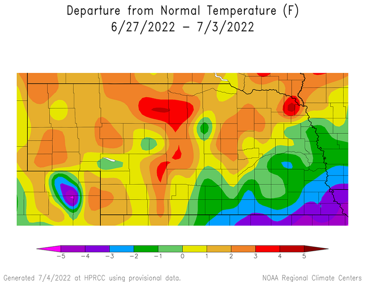
Although Nebraskans did get some limited relief from hot temperatures this past weekend, most of last week was dominated by high temperatures consistently in 90s to low 100s across the northwestern three-fourths of the state. Average temperature anomalies ranged from 1°F to 4°F above normal across the northern half of the state, as well as southwest Nebraska as depicted in Figure 3. Below-normal anomalies were mainly confined to south-central, east-central and southeast Nebraska where cloud cover was more extensive and limited daytime heating compared to western regions of the state.


The highest maximum temperature recorded each day across the state ranged from 89 to 104°F using airport locations June 27 through July 3. Daily high temperatures are as follows: June 27 — 93 (Chadron), June 28 — 99 (Ogallala), June 29 — 104 (Chadron, Ogallala, Valentine), June 30 — 100 (McCook), July 1 — 89 (Valentine), July 2 — 92 (Scottsbluff), July 3 — 101 (Chadron). With drier air in place across the Panhandle, it is not surprising that maximum temperatures were hot for this time of year. However, the dry air mass also contributed to unseasonable cool low temperatures.
The lowest daily minimum temperature recorded each day across the ranged from 43°F to 59°F using airport locations June 27 through July 3. The marks the second consecutive week that the daily low temperature readings were all recorded at Panhandle locations. Daily low temperatures are as follows: June 27 — 43 (Alliance), June 28 — 45 (Alliance), June 29 — 55 (Alliance), June 30 — 51 (Kimball), July 1 — 53 (Kimball, Chadron), July 2 — 58 (Kimball), July 3 — 59 (Gordon, Kimball). So the diurnal spread between maximum and minimum temperatures ranged from 34°F on July 2 to 54°F on June 28. The Panhandle would normally experience a diurnal temperature range of 30-35°F this time of the year.
Crop Progress
With above-normal temperatures and below-normal moisture this past week across a large swath of the northern and southern third of Nebraska, it is not surprising that the Nebraska Agricultural Statistics Service (NASS) reported declines in crop conditions and soil moisture estimates in their most recent crop progress report. Wheat and pasture had the largest crop rating declines, likely due to the fact that the vast majority of acreage dedicated to these crops are located across western Nebraska where last week's heat and dryness were most pronounced.
NASS reports that pastures as of July 3 were rated 24% very poor, 32% poor, 31% fair, 12% good and 1% excellent. Compared to conditions through June 26, the very poor category doubled from 12% and good conditions shrank in half from 24% the previous week. There was also a 3-percentage point increase in the poor rating, while the pastures rated good dropped 3 percentage points.
The wheat crop continues to deteriorate as the first harvest information for 2022 was included in this week’s crop report. NASS estimates that 22% of crop has been harvested compared to 6% last year and the five-year average of 11%. Below-normal moisture from last fall through this spring, coupled with above-normal temperatures during June sped up maturity and were contributing factors for below-normal yields across the western third of Nebraska. Current crop conditions reflect these disappointing yields and NASS reports that the wheat crop is currently rated 28% very poor, 17% poor, 38% fair, 15% good and 2% excellent. The very poor category expanded 12 percentage points compared to conditions on June 26.
Topsoil and subsoil moisture readings declined last week due to above-normal temperatures and the lack of widespread precipitation. NASS reports that topsoil moisture as of July 3 was rated 23% very short, 37% short, 39% adequate and 1% surplus. Subsoil moisture was rated 26% very short, 33% short, 40% adequate and 1% surplus. Topsoil moisture rated very short increased three percentage points compared to the previous week, while the adequate rating dropped an equivalent three percentage points. Subsoil moisture rated very poor increased five percentage points compared to the previous week, which was at the expense of the short and adequate ratings that decreased two and three percentage points, respectively.
Corn and soybean condition ratings declined slightly during the past week, while sorghum showed a slight improvement. For both corn and soybeans, 12% of the crop is rated very poor to poor, both unchanged from the previous week. Corn rated good to excellent as of July 3 is 62%, a decrease of two percentage points from the previous week. Soybeans rated good to excellent is 61%, a decrease of one percentage point from the previous week. Sorghum rated very poor to poor was 10% this week, an improvement of one percentage point from the June 26 rating. The crop was rated 63% good to excellent, which is an improvement of one percentage point from the previous week.
With thunderstorm development the past two days across Nebraska and several more opportunities for moisture this week, expectations are that warm season crops will show improvement when NASS releases their next crop progress report on July 11. Areas receiving more than two inches of moisture from 8 a.m. July 5 through 8 a.m. July 12 are the most likely candidates for drought improvement when next week’s U.S. Drought Monitor is released on July 14.
Weather Outlook
Although Nebraska has seen a significant increase in thunderstorm activity the past two days, the GFS model run issued the morning of July 6 has turned hotter and significantly drier after July 8. Last week, the GFS model was indicating that hot and dry conditions would develop from July 11 through July 18, before cooling back into the 80s, along with periodic thunderstorm chances. The GFS model currently indicates that hot and dry conditions are favored from July 12 through July 22.
In the short term, the GFS model indicates that energy will rotate along the periphery of the southern Plains upper air ridge July 7 and 8. Monsoonal moisture will be drawn northward through the southern and central Rocky Mountains on the backside of the ridge, then shunted eastward across Nebraska. On July 7, the southern half of Nebraska has the best opportunity for widespread moisture, with some localized heavy precipitation (>2 inches) south of the I-80 corridor. The upper air ridge begins to push northward on July 8 and this would shift the best opportunity for precipitation to the northern half of Nebraska.
The ridge builds further northward on July 9, but also deepens the upper air trough forecast to be over the eastern Corn Belt. A piece of energy pushing southeast on the backside of this trough is forecast to generate showers and thunderstorms across the eastern third of Nebraska, with the northeast fourth of the state having the best opportunity for widespread moisture. From July 10 through July 22, the GFS model indicates that the only precipitation opportunities for Nebraska are on July 12 and July 21.
On July 12, the GFS model indicates an upper air trough will move across the northern High Plain and drive a surface cold front into southern Nebraska. Precipitation is forecast to move southward during the day and weaken as it approaches the Kansas border. North-central and northeast Nebraska are currently depicted as having the highest precipitation probabilities with this cold front. Another upper air trough is forecast to cross the northern Plains July 20 and drive a cold front through the northern half of the state on July 21. The GFS model currently limits precipitation to the northern third of Nebraska and appears to generate less than 0.50 inches of moisture.
High temperatures are forecast to warm through the remainder of this week according to the GFS model, with upper 90s to low 100s possible July 9-10. A slight cool down is forecast July 11-12 as an upper air trough moves across the northern High Plains and high temperatures should be around 10 degrees cooler. The southern Plains upper air ridge is forecast to build northward and dominate Nebraska’s weather July 13-20. High temperatures are forecast to be in the 90s to low 100s during this period, with the hottest temperatures located over the western half of the state.
The GFS model does show a slight cool down on July 21 (5-7°F cooler) before rebounding back into the 90s and low 100s July 22. Hopefully, this recent movement toward a longer period of heat coupled with little to no moisture by the GFS model is overblown. However, if it is not, then this week’s precipitation events will be important to carry crops through this hot spell, especially with the onset of warm season crop reproduction.
