Weather Review
The past two weeks have brought above-normal temperatures and below-normal precipitation to the central and southern High Plains region, including a sizeable portion of Nebraska. An upper air ridge centered over north-central Texas extended northward into the central High Plains and shifted the primary storm track from the northern Rockies into the western Great Lakes. Subsequently, very few frontal boundaries worked through Nebraska and precipitation events were infrequent and localized when they did occur. With warm season crops reaching their reproductive phases, widespread heat in combination with below-normal moisture has begun to stress dryland crops statewide.
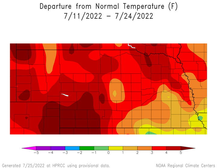
According to Figure 1, average temperatures were above normal statewide for the July 11-24 period. Southwest and the western half of northeast Nebraska had average temperature anomalies of 4-6°F above normal, while the remaining areas in the northwestern two-thirds of the state were 3-5°F above normal. South-central, east-central and southeast Nebraska average temperature anomalies were generally 1-3°F above normal, except for the extreme southeastern corner, where anomalies were up to 1°F above normal. Depleted soil moisture reserves have likely contributed to higher average temperature anomalies across northeast and southwest Nebraska, which failed to see the beneficial May and June rain events that were more common across the southeastern third of the state.

Maximum temperatures were consistently in the 95–110°F range during the past two weeks across the western third of the state. When examining the daily maximum temperatures recorded at airport locations across the state, there were only three days when at least one station failed to reach 100°F. These occurred on July 11, July 12 and July 24. From July 13 through July 23, the highest daily maximum temperature reading recorded in the state occurred six times at McCook and three times at Chadron. The hottest daily maximum temperature during this stretch was on July 18 when McCook recorded 111°F, which was closely followed by a 109°F reading on July 23 and a 108°F reading on July 14.
Usually when maximum temperatures consistently move into the upper 90s and beyond during the summer in Nebraska, high pressure dominates our weather and precipitation events become sparse. Such has been the case these past two weeks as there were only three events that could be considered widespread. A narrow band of precipitation from southwest through east-central Nebraska dropped 0.25 to 1.00 inches of moisture for the 24-hour period ending the morning of July 11. The second event occurred during the 24-hour period ending the morning of July 17 when a band of 1-2 inches of moisture fell just east of Loup City south-southeast through Hebron, then eastward to the Missouri border. The final event occurred during the 24-hour period ending the morning of July 22 when 0.25 to 1.50 inches of moisture was reported in a narrow corridor from Imperial to Broken Bow.
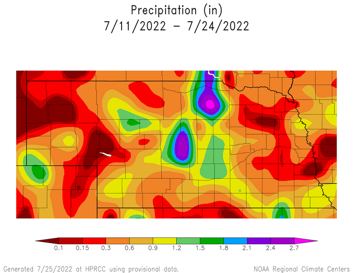
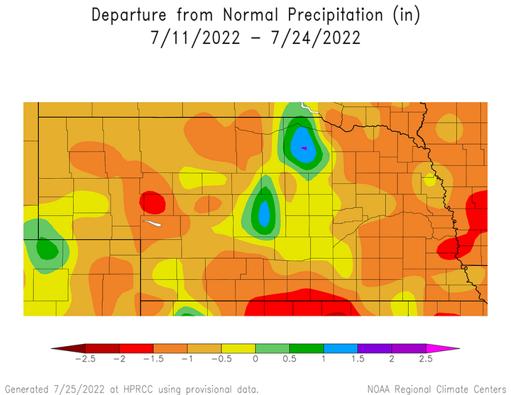
The lack of widespread precipitation across the state from these three precipitation events over the past two weeks can be viewed in Figure 2. Large regions of the state failed to accumulate 0.50 inches of moisture, including northeast and east-central Nebraska, as well as portions of the Panhandle, north-central, south-central and southwest Nebraska. If these cumulative precipitation totals are compared to normal expectations (Figure 3), the only areas of the state that received above-normal moisture were pockets of the northeast and south-central Sandhill region, as well as the extreme southwestern corner of the Panhandle.


Crop Progress
With above-normal temperatures and below-normal precipitation being the dominant pattern over the past two weeks, it is not surprising that the latest Nebraska Agricultural Statistics Service (NASS) crop progress report through July 24 shows broad based deterioration to crops, pastures and soil moisture. NASS currently rates topsoil moisture conditions 26% very short, 42% short, 31% adequate and 1% surplus. Compared to conditions on July 11, the topsoil rating point changes (in parenthesis) are as follows: very short (+6), short (+14), adequate (-18), surplus (-2). Subsoil moisture conditions are rated 29% very short, 37% short, 34% adequate and 0% surplus. Compared to conditions on July 11, the subsoil rating point change (in parenthesis) is as follows: very short (+8), short (+6), adequate (-13), surplus (-1).
NASS reports that the conditions ratings for corn have declined over the past two weeks. Corn on July 24 was rated 8% very poor, 10% poor, 25% fair, 43% good and 14% excellent. Compared to conditions on July 11, the net rating point change (in parenthesis) for corn are as follows: very poor (+4), poor (+1), fair (+1), good (-7), excellent (+1). As of July 24, corn silking is estimated to be 68% complete, which compares to 80% last year and the five-year average of 75%. Corn in the dough stage is estimated to be 8%, which compares to 13% last year and the five-year average of 15%.
The condition of the soybean crop on July 24 according to NASS was 4% very poor, 9% poor, 27% fair, 47% good and 13% excellent. Compared to conditions on July 11, the net rating point change (in parenthesis) for soybeans are as follows: very poor (0), poor (+2), fair (+6), good (-8), excellent (0). NASS estimates that 67% of the crop is blooming, which compares to 83% last year and the five-year average of 77%. Thirty-one percent of the crop is estimated to be setting pods, compared to 49% last year and the five-year average of 37%.
Since southwest Nebraska is the major growing region for grain sorghum in the state, it shouldn’t be surprising that condition of the crop deteriorated over the past two weeks due to multiple days when maximum temperatures reached or exceeded 100°F, along with the lack of widespread rainfall. NASS reports that sorghum on July 24 was 6% very poor, 21% poor, 34% air, 32% good and 7% excellent. Compared to conditions on July 11, the net rating point change (in parenthesis) for sorghum are as follows: very poor (+4), poor (+5), fair (+7), good (-16), excellent (0). Sorghum in the heading stage was estimated to be at 20%, compared to 18% last year and the five-year average 26%.
Perhaps the smallest crop condition decline over the past two weeks has been in the pasture ratings tabulated by NASS. They report that as of July 24, pastures were rated 24% very poor, 26% poor, 30% fair, 18% good and 2% excellent. Compared to conditions on July 11, the net rating point change (in parenthesis) for pastures are as follows: very poor (0), poor (+1), fair (-2), good (0), excellent (+1). It is likely that the surplus moisture that occurred over the past two weeks across the south-central and northeastern Sandhill region led to pasture improvements that were offset by hot and dry conditions across the Panhandle and southwestern Nebraska.
Weather Outlook
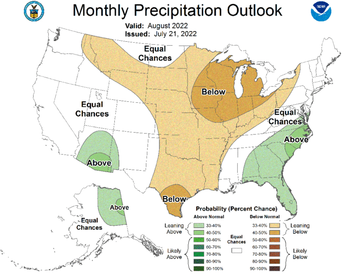
The Climate Prediction Center (CPC) issued their preliminary August temperature and precipitation outlooks for the United States on July 21. Above-normal temperatures are favored across most of the continental United States, with the highest likelihood of occurrence assigned to eastern Texas, Louisiana, Arkansas and southeast Oklahoma (Figure 4). Above-normal temperatures are favored for Nebraska, with the highest probability of occurrence assigned to the southwestern half of the state. CPC indicates that a weak chance for below-normal moisture is favored for the entire state of Nebraska, with the highest probability of occurrence on a national scale being assigned to the Great Lakes and central Corn Belt (Figure 5).


Unfortunately, there is no indication in the short-term models that widespread precipitation will occur over the next two weeks across Nebraska and our brief stint with below-normal temperatures will come to an end by this weekend. The upper air trough that brought cool Canadian air to the region is forecast to slowly weaken for the remainder of this week and high pressure over the western United States will build eastward toward the central United States. The GFS model run issued the morning of July 26 indicated that two pieces of energy would rotate around the backside of the Great Lakes upper air trough before a drier and warmer pattern developed. The first piece of energy was expected to generate showers and thunderstorms from the evening of July 26 through the morning of July 27 from north-central through eastern Nebraska. The second piece of energy was forecast to impact the western third of the state from the evening of July 27 into the morning of July 28.
High temperatures will begin to gradually warm as the weekend approaches and forecast to warm from the 80s July 26-29 into the 90s July 30-31. As the western U.S. upper air ridge builds eastward, much warmer temperatures are forecast to develop by the GFS model. From Aug. 1-5, high pressure aloft is currently forecast to bring widespread 100–105°F high temperatures to the western half of the state. There is the potential for 105-110°F high temperatures across southwest Nebraska Aug. 3-4. The GFS model keeps the high temperatures across the eastern half of the state in the middle to upper 90s Aug. 1-2, before spreading triple digit reading into the region Aug. 3-5. With high pressure forecast to be in control, no precipitation is currently forecast statewide from July 31 through Aug. 5.
The GFS model does indicate that a possible break from our next forecasted stretch of above-normal temperatures may occur Aug. 6-10 as an upper air trough is forecast to traverse the northern Rockies and High Plains region. This would put Nebraska on the southern periphery of the upper air trough and increase our chances for precipitation as energy rotates around the trough. According to the GFS model, scattered thunderstorms are possible across the northwestern half of the state Aug. 6 and the eastern half of the state Aug. 7. Additional rainfall events are indicated by the GFS model for the central third of the state Aug. 8 and the southern third of Nebraska on Aug. 10. High temperatures are forecast to drop back into the upper 80s to middle 90s Aug. 6-10.
Since the GFS model switches from a strong upper air ridge into a stormier pattern late next week, my forecast confidence is low. It is difficult for weather models to pinpoint exactly when a strong upper air ridge will weaken and how far southward it will be displaced when it does weaken. Thus, it is entirely possible that the GFS model is breaking the upper ridge down too soon and/or is overly aggressive with precipitation events currently forecast once the ridge does break down. The bottom line is that another round of extended heat is likely with the possibility that precipitation chances will increase late next week. Therefore, additional crop deterioration is likely before there is any chance of widespread precipitation developing across the state.
