Weather Review
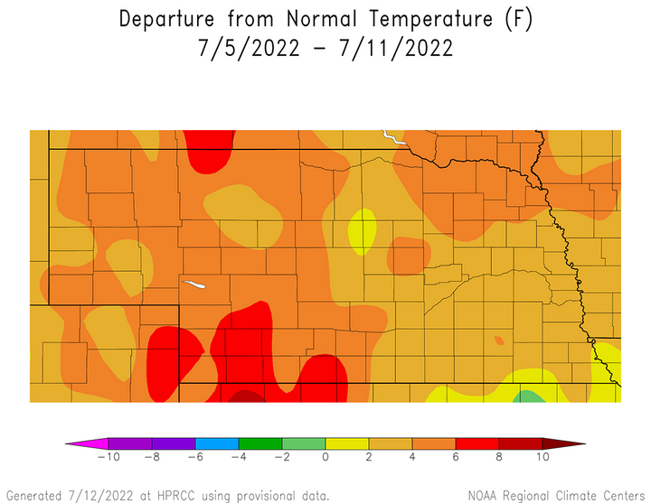
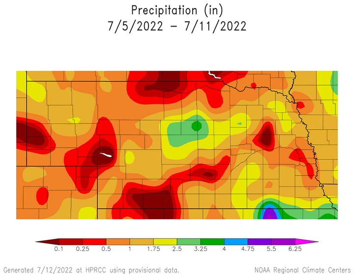
Above-normal temperatures were reported statewide last week as Nebraska was on the northern fringe of an expansive upper air ridge centered over the southern Plains. According to Figure 1, average temperature anomalies were generally 2-4°F above normal, except for southwest Nebraska where anomalies were 6-8°F above normal. Monsoonal moisture wrapped around this upper air ridge and combined with pieces of energy ejecting eastward out of the central Rockies July 4-8 to produce daily thunderstorm activity. This daily activity varied significantly across the state, but most areas received at least an inch of moisture during the period, Unfortunately, there were some pockets of central, north-central and western Nebraska that missed these generous rain totals (Figure 2).


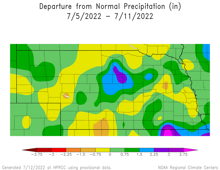
There were some localized areas of heavy precipitation (3-5 inches) that fell across the southern Sandhill region, as well as along the Kansas border from south-central through southeast Nebraska. Compared to normal, these same areas had positive weekly precipitation anomalies of 1.50 to 3.00 inches (Figure 3). Although moisture was not as generous outside of these areas, positive precipitation anomalies of 0.75 to 1.50 inches were observed from west-central through northeast Nebraska, the northern half of the Panhandle and areas south of I-80 east of Kearney. The most concentrated areas of below-normal moisture were concentrated in the Ogallala, Norfolk and Sidney to McCook areas.

This moisture was very welcome across the state, especially considering that high temperatures breached the 100°F mark across western Nebraska July 4-5 and July 9-10. Daily maximum and minimum temperature extremes reported from airport location across the state are as follows:
- July 4 — 102, McCook/58, Chadron, Kimball
- July 5 — 103, McCook/59, Chadron
- July 6 — 91, Valentine, Wayne/56, Kimball
- July 7 — 92, Chadron/51, Kimball
- July 8 — 96, Chadron/58, Kimball
- July 9 — 107, Chadron/61, Kimball
- July 10 — 111, McCook/61, Kimball
At least one location in the state received more than two inches of precipitation daily between July 4-8 before the monsoon enhanced moisture shifted east of Nebraska. The greatest 24-hour precipitation totals report across the state using NERain observation data are as follows:
- July 4 — 3.25 inches, Spalding 0.2 SW
- July 5 — 2.03 inches, York 1.4 N
- July 6 — 3.59 inches, Lawrence 0.3 SSE
- July 7 — 3.45 inches, Byron 4.1 NNE
- July 8 — 3.52 inches, Anselmo 11.8 WSW
- July 9 — 0.27 inches, St. Paul 2.7 NNE
- July 10 — 0.23 inches, Grant 5.1 WNW and Burton 0.1 SW
Crop Progress
The latest Nebraska Agricultural Statistics Service (NASS) crop progress report of conditions through July 10 indicates there were modest improvements when compared to the prior week. Although high temperatures breached the 100°F across western Nebraska four of the seven days covered in NASS’s analysis, rainfall was sufficient to offset crop water demands at most locations across the state. Monsoonal moisture moving around the periphery of a high-pressure ridge centered over the southern Plains, along with pieces of energy moving eastward out of the central Rockies, led to periodic thunderstorm activity. There were pockets of below-normal moisture across southwest, south-central, west-central, north-central and northeast Nebraska, which likely contributed to localized crop condition declines and tempered overall improvements to state level ratings.
There were solid improvements in this week’s soil moisture ratings according to NASS. Topsoil moisture as of July 10 was rated 20% very short, 28% short, 49% adequate and 3% surplus. Compared to July 3 conditions, there was a 12-percentage point reduction in the very poor to poor ratings, while the adequate rating gained 10 percentage points and the surplus rating gained 2 percentage points. Subsoil moisture was rated 21% very poor, 31% poor, 47% adequate and 1% surplus. Subsoil moisture rated very poor to poor decreased seven percentage points compared to conditions on July 3, which led to a seven-percentage point increase in adequate category. Surplus subsoil moisture rated surplus was 1%, unchanged from the previous week.
Pastures as of July 10 were rated 24% very poor, 25% poor, 32% fair, 18% good and 1% excellent, according to NASS. Compared to July 3 conditions, there was no decrease in pastures rated very poor, but a seven-percentage point decrease in the poor category. This decrease was offset by a one-percentage point increase in the fair category and a six-percentage point increase in the good category. These improvements will likely be temporary due to widespread heat and dryness forecast for the remainder of this week across western Nebraska.
The winter wheat harvest is estimated to be 36% complete as of July 10, which compares to 21% a year ago and the five-year average of 32%. With a hot and dry forecast this week, the wheat harvest should breach the halfway mark when NASS issues their crop progress report next week. The crop is currently rated 20% very poor, 24% poor, 39% fair, 16% good, and 1% excellent. Compared to conditions on July 3, there was an eight-percentage point decrease in the very poor category and a seven-percentage point increase in the poor category. The fair and good categories both increased one percentage point, while the excellent rating decreased one percentage point.
Corn is entering its reproductive stage but is behind last year and the five-year average, according to NASS. Corn in the silk stage was estimated at 8% as of July 10, which compares to 17% a year ago and the five-year average of 19%. Four percent of the crop is rated very poor, 9% poor, 24% fair, 50% good and 13% excellent. Compared to conditions on July 3, there was a one- percentage point increase in the very poor category, a two-percentage point decline in the fair category, a one-percentage point decline in the good category and a two-percentage point increase in the excellent category.
The condition of the soybeans improved to a greater extent than the corn crop when compared to the previous week. NASS indicates that soybeans on July 10 were rated 4% very poor, 7% poor, 21% fair, 55% good and 13% excellent. Soybeans rated very poor was unchanged from the previous week, while the poor category decreased one percentage point. There was a six-percentage point decline in the fair rating, while the good rating increased six percentage points and the excellent category expanded by one percentage point.
Finally, sorghum conditions ratings declined this week and was likely the result of above-normal temperatures and below-normal precipitation for a large portion of south-central and southwest Nebraska where the majority of the crop is grown. NASS reports that sorghum is rated 2% very poor, 16% poor, 27% fair, 48% good and 7% excellent as of July 10. Compared to July 3, there was a one-percentage point increase in the very poor rating, a seven-percentage point increase in the poor rating, an 11-percentage point decrease in the good rating and a three-percentage point increase in the excellent rating. The fair rating category was unchanged.
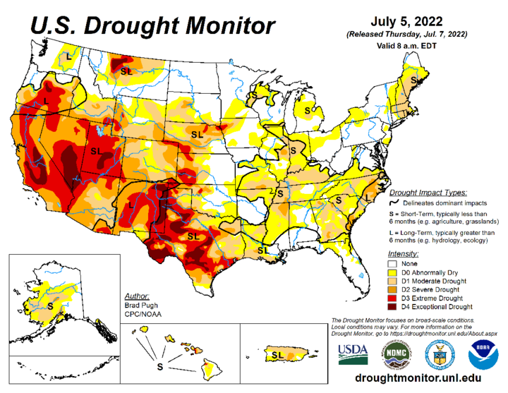
Figure 4 shows the latest U.S. Drought Monitor map of conditions through 8 a.m. Central Daylight Savings Time on July 5 and partially reflects the cumulative moisture received last week across the state. Additional improvements are likely when this week’s map is released Thursday morning for conditions through the morning of July 12. However, with widespread 98°F to 105°F high temperatures forecast this week for western Nebraska and low precipitation probabilities, crop ratings are expected to decline and drought coverage expand when next week’s updates are issued.

Weather Outlook
When last week’s weekly agricultural weather report was issued, the GFS model was indicating that the Central Plains would be dominated by upper atmospheric ridging with little to no precipitation indicated July 14-22. The GFS model run issued the morning of July 12 still has a hot forecast in place, but now includes some weak precipitation chances over the next 10 days. The most plausible explanation for this slight uptick in moisture chances is due to the forecasted position of the upper air ridge to our south and how far north it will extend over the next two weeks.
The GFS indicates the southern Plains upper air ridge will build northward into the central and northern Plains July 12-16, then be pushed south and westward July 17-21 in response to an upper air trough moving across the northern Plains. This upper air ridge is then forecast to build north and east from the southern Great Basin July 23-27 before another trough begins to move across the northern Plains July 28 and pushes the northern periphery of the ridge southward. Under this scenario, the GFS model indicates widespread 90s east to low 100s west July 12-16, cooling into the upper 80s east to upper 90s west July 17-21. High temperatures are then forecast to warm back into the 90s east to low 100s west July 22-27, before cooling back into the upper 80s east to the middle 90s west on July 28 (end of the GFS model period).
Although the GFS model has increased moisture chances during the next 10 days compared to last week, there is no signal currently for widespread moisture. All of the precipitation chances shown by the GFS models occur during the late evening and overnight hours. The following dates indicate the when the GFS hints at possible precipitation development during the evening hours, which would continue into the following morning:
- July 12 — Southern Panhandle – southwest Nebraska
- July 13 — South-central Nebraska
- July 14 — Eastern half of Nebraska
- July 16 — Northwest half of Nebraska
- July 18 — North-central and northeast Nebraska
- July 19 — Eastern half of Nebraska
- July 20 — Central third of Nebraska
The GFS model then indicates that the next precipitation opportunity would occur July 27-28 across the western third of the state.
Even with the GFS model increasing precipitation chances over the next 10 days, the cumulative precipitation forecast from all of these events remains below 0.25 inches. Unless these events can be aided by the development of the low-level jet transporting Gulf of Mexico moisture northward during the overnight hours, these low probability events will not offset high water use demand by warm-season crops currently entering their reproductive phase. Crops, pastures and soil moisture are likely to deteriorate in non-irrigated areas over the next two weeks. If high temperatures consistently breach the middle 90s, this expected deterioration will likely be swift across areas that currently lack adequate soil moisture.
