Weather Review
Above normal temperatures dominated this past week and high temperatures warmed back into the upper 90s to low 100s. The upper air ridge across the southern Plains built north and east as the week progressed. An upper air trough crossing the northern Plains brought cooler weather to the state as the weekend progressed. Unfortunately, widespread precipitation failed to materialize and crop conditions declined for another week as hot temperatures and the lack of adequate soil moisture reserves continued to stress crops and pastures.

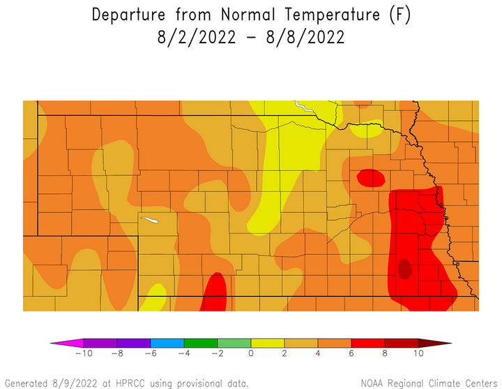
By Saturday evening the cold front had reached central Nebraska, but it took another 24 hours for it to clear the areas south of I-80 and east of U.S. Highway 81. This sharp cool down helped reduced average temperature anomalies during the past week across western Nebraska according to Figure 1. A large area of east-central and southeast Nebraska was 6-8°F above normal, as well as a small pocket around the McCook area. In general, the western half of the state reported average temperature anomalies 2-6°F above normal compared to 2-8°F above normal across eastern Nebraska. The one exception was the north-central through south-central Sandhill region, where average temperature anomalies ranged from normal to 2°F above normal.
The daily maximum temperature extremes for airport location provided by the National Weather Service are as follows: July 1 — 103°F (Chadron, Scottsbluff), July 2 — 109°F (Valentine), July 3 — 98°F (McCook, Norfolk, Tekamah), July 4 — 105°F (Chadron), July 5 — 109°F (Chadron), July 6 — 103°F (McCook), July 7 — 100°F (Falls City).
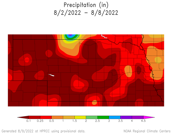
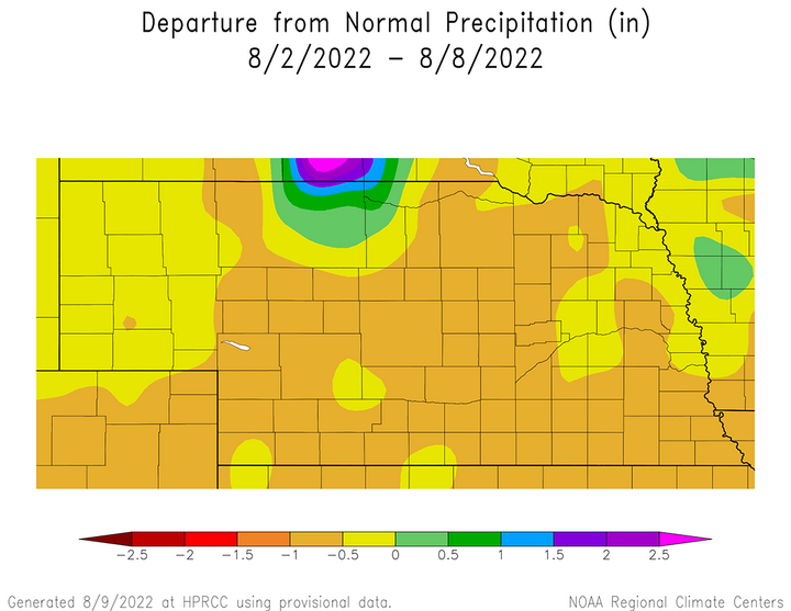
According to published precipitation reports from NERain observers, there was at least one location that reported measurable moisture every day last week. Most of the NERain observers reported less than 0.20 inches of moisture in any individual event and higher totals were limited to less than three counties in most instances. The cumulative precipitation received Aug. 2-8 is depicted in Figure 2 and these small precipitation pockets are readily apparent. More importantly, Figure 3 indicates that the only area of the state to receive above normal moisture was around Valentine, Nebraska.
The daily maximum precipitation values reported from NERain observers are as follows: July 1 — 1.20 inches (Harrison 6.4 W), July 2 — 0.60 inches (Bloomfield 0.1 ENE), July 3— 0.46 inches (Osceola 7.1 W), July 4 — 0.32 inches (Hardy 4.3 E), July 5 — 0.92 inches (Valentine 0.4 E), July 6 — 2.00 inches (Gordon 5.3 E), July 7 — 1.17 inches (Clay Center2.8 W).


Crop Progress
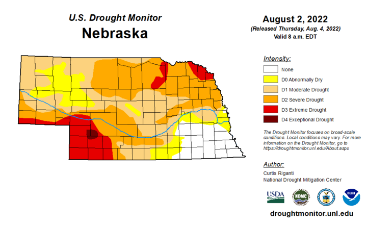
The latest U.S. Drought Monitor (Figure 4) represents conditions through 7 a.m. Aug. 2, so most of the impacts from last week’s heat and dry conditions will not be reflected until this week’s edition is released. Although normal conditions are still depicted for the southeastern fourth of the state, recent visual observations reported to the Nebraska State Climate Office suggest that corn and soybeans are exhibiting moisture stress. Therefore, most of this area is expected to be upgraded to abnormally dry conditions this week, with further deterioration probable over the next two weeks based upon the most current weather forecast.

Extreme drought (D3) is currently depicted for the southwest corner of the state, the southern Panhandle border region, extreme northeast Nebraska and parts of the eastern Niobrara River valley. A small pocket of exceptional drought (D4) covers southeastern Chase County, northwest Hayes County and southwest Lincoln County. This past week brought multiple days of high temperatures exceeding 100°F and below-normal moisture across western Nebraska. These conditions are expected to lead further expansion of D3 and D4 across the southwest and west-central Nebraska, as well as the southern Panhandle.
Warm-season crops continue to deteriorate on a statewide basis according to the Nebraska Agricultural Statistics Service (NASS) crop progress report issued Aug. 8 based upon survey data through Aug. 7. Corn, soybeans and sorghum have exhibited a steady drop in crop condition ratings since early July. NASS data indicates that warm-season crops rated good to excellent have dropped from the 70% range into the 50-55% range for corn and soybeans, while sorghum has dropped below 40%.
The sorghum crop has the lowest overall crop rating of the warm season crops grown in Nebraska according to NASS. As of Aug. 7, the sorghum crop is rated 10% very poor, 29% poor, 36% fair, 20% good and 5% excellent. Compared to conditions on July 31, sorghum rated good to excellent dropped 11 percentage points. Only 4% of the grain heads are showing color, compared to 8% last year and the five-year average of 7%.
The state corn crop also deteriorated according to NASS and as of Aug. 7 was rated 11% very poor, 12% poor, 27% fair, 40% good and 10% excellent. Corn rated good to excellent dropped four percentage points from the previous week. In a normal year, corn rated good to excellent at the beginning of August is between 60% and 70%. NASS reports that 45% of the crop was in the dough stage compared to 60% last year and the five-year average of 52%.
The state soybean crop continued to deteriorate and NASS rates the crops current condition as 7% very poor, 11% poor, 28% fair, 44% good and 10% excellent. For comparison, conditions on July 31 were rated 54% good to excellent, so soybeans dropped another four percentage points last week. NASS reports that 66% of the crop was setting pods compared to 81% last year and the five-year average of 71%. Although soybeans are setting pods, weather forecasts through the end of August would suggest that below-normal moisture and above-normal temperature will have a detrimental impact on pod fill.
Topsoil and subsoil moisture estimates from NASS deteriorated slightly during the past week, with most of the changes occurring in the adequate and short categories. As of Aug. 7, topsoil moisture was rated 32% very short, 42% short, 26% adequate and 0% surplus. There was a four-percentage point decline in the adequate category and a three-percentage point increase in the short category. Subsoil moisture was rated 30% very short, 41% short, 29% adequate and 0% surplus. There was a three-percentage point decline in the adequate category, which was offset by two-percentage point increase in the short category.
Finally, the conditions of pastures and rangeland on Aug. 7 according to NASS was 33% very poor, 28% poor, 30% fair, 9% good and 0% excellent. There was a one-percentage point expansion for pastures/rangeland rated very poor and no change in the poor category. However, the fair category increased five percentage points while the good and excellent categories both decreased two percentage points.
Weather Outlook
There would be no greater satisfaction than to say the current short-term weather outlook offers significant drought relief. Unfortunately, that doesn’t appear to be in the cards according to the latest GFS weather model issued the morning of Aug. 8. Heat is projected to return to the central Plains with few precipitation opportunities, which supports further warm-season crop deterioration over the next two weeks.
After cooler weather statewide Sunday and yesterday, the upper air ridge that has brought above-normal temperatures and below-normal moisture to most of the central and southern High Plains is forecast to dominate Nebraska’s weather through Monday, Aug. 15. Currently the GFS model does indicate that this ridge will break down Aug. 16-20 in response to a trough moving across the northern Plains and deepening over the Great Lakes. This will allow a cooler Canadian air mass filter southward before the upper air ridge begins to build back into the region Aug. 21-25 (end of model forecast period).
Maximum temperatures were forecast to warm from the middle 80s northeast to low 90s southwest Aug. 9, then warm into the low 90s east to upper 90s west Aug. 10. The GFS model indicates that these high temperatures should continue through Aug. 15 and a few 100°F high temperatures may materialize across the western third of the state Aug. 12-13. No precipitation is depicted on the GFS model through Aug. 13.
An upper air trough is forecast to move from the Pacific Northwest to the Great Lakes August 14-18. As this trough moves across the northern Plains in August, the GFS model hints that it will interact with monsoonal moisture moving northward through the southern half of the Rocky Mountains. Therefore, isolated to scattered thunderstorms are possible across the Panhandle during the late afternoon and overnight hours of Aug. 14-16. The most widespread coverage is indicated from the evening of Aug. 16 through the morning of Aug. 17, and total moisture appears to be less than 0.50 inches. Some of this moisture may make it to eastern Nebraska, but currently the GFS model indicates that less than 0.25 inches of moisture is likely.
The GFS model indicates that the upper air trough will strengthen over the Great Lakes Aug. 18-20, which will move cooler air from southern Canada into Nebraska. Daily high temperatures are forecast to cool into the 80s during the period. Unfortunately, the GFS model lacks any precipitation signal for Nebraska during this cool down. High temperatures appear likely to return to the 90s Aug. 21-25 as the Great Lakes upper air trough weakens and the western U.S. upper air ridge expands eastward under mostly dry conditions.
