Weather Review
Once again, the upper air pattern this past week featured an upper air ridge over the southern Plains and an eastward moving upper air trough crossing the northern Plains. Unfortunately, weather models underplayed the strength of the southern Plains high pressure and the forecast cool down for the second half of last week was short-lived. With the lack of widespread moisture, crops deteriorated further due to insufficient soil moisture as they approach the finish line of the 2022 cropping season.
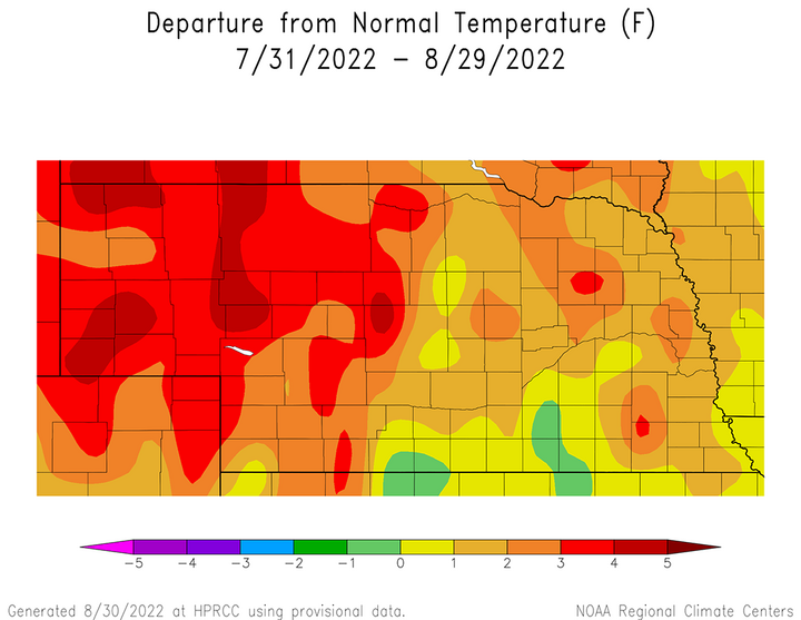
Average temperature during the past 30 days (Figure 1) are running 2-5°F above normal across the western third of the state, while eastern areas have been slightly cooler with departures of 1-3°F above normal. A small area encompassing parts of south-central and southeast Nebraska was near normal (1°F to -1°F departures).
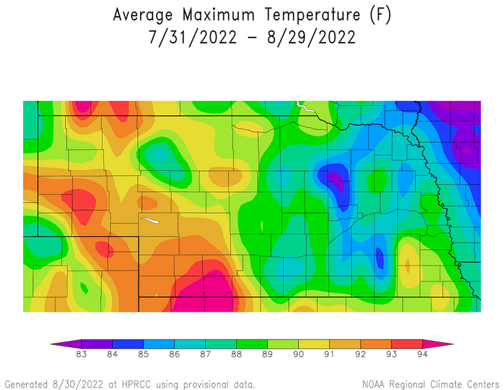
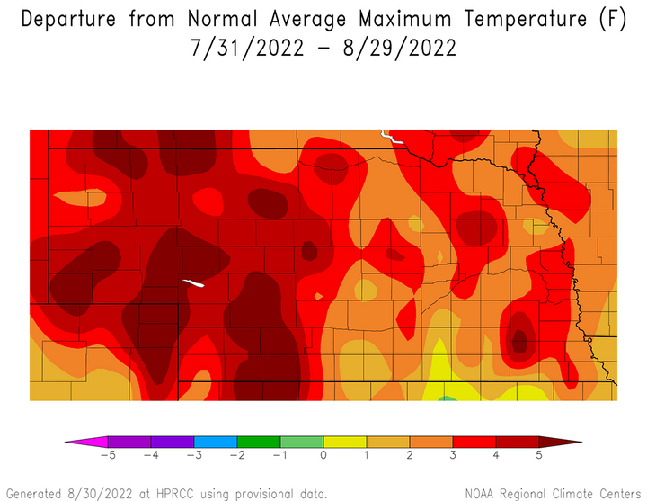
Maximum temperatures have been the biggest contributor to these 30-day average temperature anomalies. Figure 2 shows that over the last 30 days, maximum temperatures have averaged over 90°F across the western third of the state compared to 85-90°F across eastern Nebraska. Therefore, maximum temperature anomalies the past 30 days are 4-6°F above normal across the western third of the state and 2-4°F above normal across eastern Nebraska (Figure 3).
Maximum temperatures were very warm this past week and continue a trend that developed during the middle of July. Maximum temperatures exceeded 90°F in at least one location every day last week, with 95°F exceeded on six of those days. Normal daily high temperatures for the last 10 days of August range from the lower 80s northeast to upper 80s southwest.
The daily maximum temperature extremes for airport locations reported by the National Weather Service (NWS) are as follows: Aug. 22 — 93°F (Chadron, Scottsbluff), Aug. 23 — 99°F (O’Neill), Aug. 24 — 97°F (McCook), Aug. 25 — 99°F (McCook), Aug. 26 — 98°F (McCook), Aug. 27 — 96°F (McCook), 8/28 — 104°F (McCook).
The daily minimum temperature extremes for airport locations reported by the NWS are as follows: Aug. 22 — 50°F (Ord), Aug. 23 — 53°F (Kimball), Aug. 24 — 47°F (Sidney), Aug. 25 — 48°F (Sidney), Aug. 26 — 56°F (Alliance), Aug. 27 — 50°F (Alliance), 8/28 — 49°F (Alliance).
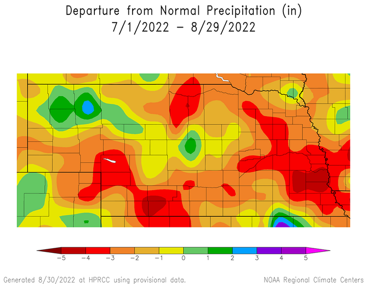
The lack of precipitation the past 45 days has led to drought expansion and intensification across Nebraska. The 60-day precipitation anomalies (Figure 4) show that precipitation shortfalls of 3-6 inches cover large areas of southwest, east-central and southeast Nebraska. The only areas showing normal to above-normal moisture extend from the northwest Panhandle into the west-central Sandhill region, along with a small region of south-central Nebraska. The remainder of the state has acquired precipitation anomalies of 1-3 inches over the past 60 days.
Figure 4 captures moisture from the first half of July that fell at the tail end of a wet period that began in May. However, it has been very dry the past 45 days for most of the state, which makes the 60-day trend appear more benign. Figure 5 depicts the precipitation trend the past 30 days and a large portion of eastern Nebraska with precipitation deficits of 2-3 inches, while areas south of the northern Panhandle have deficits of 1-2 inches.
Because western Nebraska is drier than eastern Nebraska when analyzing precipitation averages, a better comparison on the impacts of precipitation the past 30 days is to examine percent of normal moisture. Eighty percent of Nebraska has received less than 75% of normal moisture the past 30 days (Figure 6). Worse yet, 75% of the state has received less than half of their normal moisture and 50% of the state has received less than 25% of their normal moisture the past 30 days. Add in above-normal temperatures and you have a recipe for exceptional crop stress, especially when soil moisture is insufficient to meet crop demands.
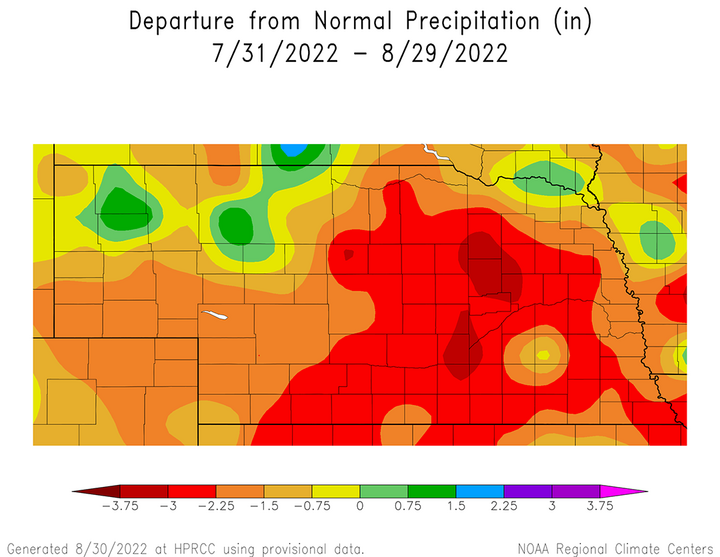

Just like the trend over the past 30 days, precipitation last week primarily occurred along the periphery of the southern Plains high pressure ridge in response to energy pivoting around the northern Plains upper air low as it moved eastward. Very isolated thunderstorms were reported across north-central Nebraska during the overnight hours of Aug. 22 and the northern tier of counties bordering South Dakota during the overnight hours of Aug. 23. As the upper low moved into the western Great Lakes, northwest flow aloft contributed to isolated/scattered thunderstorm across parts of central, northeast, and east-central Nebraska Aug. 24-28.
The daily maximum precipitation values reported from NERain observers are as follows Aug. 22 — 0.00 inches (all locations), Aug. 23 — 0.68 inches (Springview 7.7 SSW), Aug. 24 — 0.68 inches (Cody 8.2 SSW), Aug. 25 — 1.57 inches (Carroll 6.3 WSW), Aug. 26 — 0.58 inches (Bellevue 3.3 WSW), Aug. 27 — 1.02 inches (Papillion 1.3 NE), 8/28 — 1.36 inches (Papillion 1.3 NE).
Crop Progress
Another week of below-normal moisture coupled with warm temperatures led to further condition declines for grain crops, according to the latest Nebraska Agricultural Statistics Service (NASS) weekly crop report. Although at least one frontal boundary has crossed the state each week since mid-July, there has been a lack of widespread precipitation coverage has contributed to continued crop deterioration. Even when precipitation has been reported, most observers are reporting storm totals under a quarter of an inch. Those fortunate enough to receive more than 0.50 inches in any event have been located in regions where coverage has generally less than a couple of counties.
The lack of precipitation this month has led to soil moisture shortfalls and deteriorating crop yield prospects. Topsoil and subsoil moisture declined once again according to NASS for conditions as of Aug. 28. Topsoil moisture supplies were rated 46% very short, 35% short, 19% adequate and 0% surplus. Subsoil moisture supplies were rated 42% very short, 37% short, 21% adequate and 0% surplus. Topsoil moisture rated very short increased three percentage points due to a two-percentage point decrease in the short category and a one-percentage point decrease in the adequate category. Subsoil moisture rated very short increased two percentage points at the expense of the short category, which decreased an equivalent two percentage points.
With soil moisture ratings continuing to decline, Nebraska row crops dependent on that moisture continued to deteriorate like they have done this entire month. As of Aug. 28, NASS estimates the corn crop to be 17% very poor, 17% poor, 27% fair, 29% good and 10% excellent. Corn rated good to excellent increased four percentage points from Aug. 21, while corn rated good to excellent declined three percentage points. Currently, 89% of the crop has reached the dough stage, 59% of the crop has reached the dent stage and 8% of the corn crop is mature.
August precipitation strongly influences soybean yield potential and the lack of moisture this month continues to impact condition ratings for the crop. The condition of the soybean crop as of Aug. 28 according to NASS is rated 12% very poor, 16% poor, 29% fair, 34% good and 5% excellent. Compared to Aug. 21, soybeans rated very poor to poor increased six percentage points while those rated good to excellent decreased three percentage points. Ten percent of the crop is dropping leaves, which compares to 11% last year and the five-year average of 8%.
Sorghum is considered to be a more drought-tolerant crop and is grown primarily across south-central and southwest Nebraska, where precipitation can be insufficient to grow dryland corn. Numerous locations across the southwest have reported at least a dozen days where the maximum temperature reached or exceeded 100°F. As of Aug. 28, NASS estimates the condition of the sorghum crop as 35% very poor, 25% poor, 20% fair, 15% good and 5% excellent. Sorghum rated poor to very poor increased eight percentage points compared to Aug. 21. Only 33% of the crop had colored, compared to 57% last year and the five-year average of 49%.
Rangeland conditions have been impacted by the relentless heat and lack of moisture the past two months, so it comes as a pleasant surprise to see a slight improvement in this week’s crop report. NASS reports that pasture and rangeland conditions as of Aug. 28 are rated 52% very poor, 26% poor, 15% good, 6% good and 1% excellent. Rangeland and pastures rated poor to very poor dropped from 81% on Aug. 21 to 78% this week. Those rated good to excellent expanded three percentage points to 7%.
Weather Outlook
The cutoff upper air low hinted at by the GFS model last week failed to materialize as suspected. Therefore, a warmer and drier pattern materialized last week and is favored to continue for most of the first half of September. The best odds for moisture over the next 10 days appear to be associated with another upper air low moving across the northern Plains during the second half of this week. After it moves toward the Great Lakes, a return to warm and dry conditions looks likely through at least Sept. 10.
The most current run of the GFS model issued the morning of Aug. 30 indicated that another upper air low would cross the northern Plains over the next couple of days, which would bring slightly cooler air into the state and possible moisture chances across the east. As this low moves east, the GFS indicated moisture could develop from southwest to northeast Nebraska from the evening of Aug. 31 through the morning of Sept. 1. After a lull in activity, some redevelopment was possible across extreme eastern Nebraska during the evening hours. The best opportunity of widespread moisture will come with the surface cold front expected to cross the state Sept. 2-3 and generate scattered thunderstorms across the eastern half of the state.
High temperatures will cool from the low to upper 90s Aug. 30 into the middle 80s to low 90s Sept. 2. After the upper air low moves into the eastern Great Lakes Sept. 3, high pressure will build back into the central Plains. Currently, the GFS model keeps an upper air ridge in place over the central and southern Plains Sept. 3-11, which would support widespread high temperatures in the middle 80s northeast to middle 90s southwest. An upper air low is forecast to move into the northern Plains Sept. 12-13, which is the end of the GFS model run period. Significantly cooler weather would be in store by mid-month if this were to verify, along with the next opportunity for moisture across Nebraska.
