Weather Review
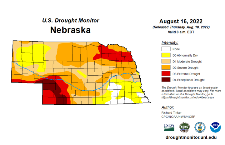
Drought conditions continue to expand across Nebraska according to the latest Drought Monitor depiction (Figure 1) issued Aug. 18 for conditions through 0700 CDT Aug. 16. The heat and dryness led to drought intensification, especially over the southern half of the state. All was not lost as extreme northeast Nebraska (northeast Knox, Cedar, Dixon and Dakota counties) NERain observers reported 1.80-2.70 inches of moisture Aug. 16. This led to a reduction of D3 (extreme drought) to D2 (severe drought).

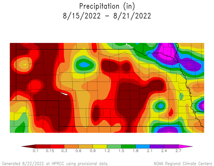
The cumulative precipitation totals reported from Aug. 15 through Aug. 22 can be viewed in Figure 1. Daily precipitation totals exceed one inch on Aug. 16 across the northwestern Panhandle and extreme northeast Nebraska. Smaller pockets occurred on Aug. 17 and were confined to parts of northeast, east-central and southwest Nebraska. It wasn’t until Aug. 20 before the next one inch-plus precipitation total was reported at Brownsville 0.2 SSW with 1.53 inches.
Although these precipitation totals sound impressive, they were a minority in an overall dry pattern last week. Less than 0.30 inches of moisture was reported last week for the western third of the state, excluding the northern third and extreme southwestern corner of the Panhandle. A similar area was located over central and south-central Nebraska. These locations are the most likely candidates for drought expansion/intensification.
It should be noted that pockets of significant severe weather developed along a cold front extending from south-central through northeast Nebraska on Aug. 18. This led to the issuance of 24 storm reports for hail one inch or greater. The worst hit area was Nance County, where three storm reports indicated hail reached 2.75 inches in diameter (Genoa, Genoa 2N, Saint. Edwards 6E). Until this storm event, there had only been four hail reports of one inch or greater hail and four wind gust reports of 57 mph or greater since the first of the month.
The daily maximum precipitation values reported from NERain observers are as follows: Aug. 15— 2.45 inches (Marsland 3 SE), Aug. 16 — 3.70 inches (Waco 4.3 SE), Aug. 17 — 0.94 inches (Fort Calhoun 2.9 SSW), Aug. 18 — 0.57 inches (Marsland 3 SE), Aug. 19 — 0.83 inches (Rockville 2.2 NW), Aug. 20 — 1.53 inches (Brownsville 0.2 SW), Aug. 21 — 0.00 inches (all stations).
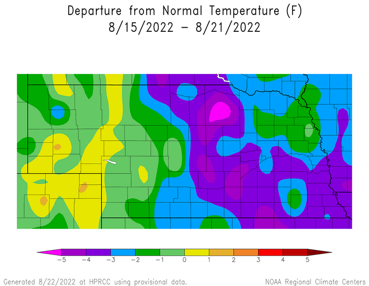
Although weekly precipitation was disappointing once again for much of the state, at least Nebraskans got to enjoy a brief taste of early fall air temperatures. Average temperature anomalies for Aug. 15-22 can be seen in Figure 3. Average temperature anomalies ranged from normal to 3°F below normal across the northern two-thirds of the Panhandle and northeast Nebraska. Across the southern Panhandle, average temperature anomalies ranged from 1°F below normal to 2°F above normal. The remainder of the state reported average temperature anomalies of 2-5°F below normal, with the strongest anomalies (3-5°F below normal) occurring across central, east-central, north-central and southeast Nebraska.


The daily maximum temperature extremes for airport location provided by the National Weather Service are as follows: Aug. 15 — 92°F (Imperial), Aug. 16 — 89°F (Chadron), Aug. 17 — 92°F (Chadron), Aug. 18 — 95°F (McCook, Ord), Aug. 19 — 91°F (McCook), Aug. 20 — 88°F (McCook), Aug. 21 — 93°F (Chadron, Scottsbluff).
The daily minimum temperature extremes are as follows: Aug. 15 — 63°F (Alliance, Kimball, Wayne), Aug. 16 — 58°F (Kimball), Aug. 17 — 52°F (O’Neill), Aug. 18 — 49°F (Sidney), Aug. 19 — 50°F (Alliance, Kimball), Aug. 20 — 42°F (Alliance), Aug. 21 — 50°F (Ord).
Crop Progress
Last week’s cooler temperatures and small areas where weekly precipitation exceeded 0.50 inches were insufficient to stem further degradation to Nebraska’s warm-season crops and rangelands. Air temperatures were cool enough across the eastern half of the state that air cooling units could be turned off and consumers could enjoy nature’s air conditioner. Without the welcome break from above-normal temperatures, it is likely that crop conditions would have deteriorated at a greater rate than reported in this week’s Nebraska Agricultural Statistics Service (NASS) crop report.
The Nebraska corn, soybean and sorghum crops reported another week of crop condition declines according to NASS. As of Aug. 21, 47% of the corn crop was in good to excellent condition, which represents a decline of five percentage points from Aug.14. Soybeans rated good to excellent were 48%, while sorghum was 20%. Soybean rated good to excellent dropped two percentage points from the previous week, while sorghum dropped one percentage point.
In response to a steady decline in the good to excellent rating for these three crops over the last six weeks, there has been a strong increase in the percentage of each crop rated poor to very poor. NASS notes that 30% of the corn crop, 20% of the soybean crop and 46% of the sorghum crop are rated poor to very poor as of Aug. 21. Compared to Aug. 14, there was a four-percentage point increase in corn rated poor or worse, a two-percentage point increase for the soybean crop and a six-percentage point increase for the sorghum crop.
Warm-season crops are quickly approaching physiological maturity and harvest activity will ramp up within the next 30 days across the state. As of Aug. 21, NASS reports 39% of the corn was in the dent stage and 3% had reached maturity. Soybeans setting pods was estimated to be 93% and leaf drop was at 3%. The sorghum crop was 75% headed, while coloring was at 17%. Corn dent and soybean leaf drop were one percentage point ahead of the five-year average. Sorghum maturity is at least one week behind the five-year average according to NASS. Sorghum in the heading stage was estimated to be 75% compared to the five-year average of 94%, while head coloring was 17% compared to the five-year average of 32%.
Rangeland and pastures also declined due to a substantial majority of western Nebraska failing to receive more than 0.25 inches of moisture for the week ending Aug. 21. NASS reports that pastures and rangeland are currently rated 53% very poor, 28% poor, 15% fair, 4% good and 0% excellent. There was an increase of nine percentage points in the very poor category from the prior week. The percentage of rangeland rated poor to very poor (81%) indicates that prospects for fall regrowth are dismal unless a very wet pattern becomes established over the next two months.
Topsoil and subsoil moisture ratings have declined so strongly over the last two months that weekly changes are primarily confined between the very short and short categories until widespread rainfall events materialize. NASS reports that topsoil moisture as of Aug. 21 was rated 43% very short, 36% short and 21% adequate. Subsoil moisture was rated 40% very short, 39% short and 21% adequate. Compared to Aug. 14, topsoil moisture rated very short increased four percentage points and subsoil moisture gained three percentage points.
Weather Outlook
There is considerable uncertainty in regard to the weather forecast over the next 16 days, especially during the Aug. 27–Sept. 4 period. The latest GFS model run issued the morning of Aug. 23 indicates that the upper air ridge currently bring dry weather to the state will begin to weaken as we approach this coming weekend. Two weak troughs are forecast to eject eastward out of the northern Rockies Aug. 26 and Aug. 28.
The first wave is forecast to bring a small chance of isolated showers to extreme northern Nebraska the evening of Aug. 26. The second wave is forecast to move into the western Dakotas, cutoff, then drift southwest toward east-central Colorado. The GFS model develops precipitation across eastern Nebraska the afternoon of Aug. 28 through Aug. 29. This precipitation shield is shifted toward western Nebraska Aug. 30-31 before the upper low dissipates on Sept. 1. High temperatures are forecast to reach the upper 80s northeast to middle 90s southwest.
Because the GFS is developing a cutoff upper air low, forecast confidence is extremely low. Although cutoff lows are fairly common, numerical weather models over forecast their development. In addition, it is very difficult for models to handle the movement of cutoff lows, let alone their longevity. If the GFS model is correct, then welcome rainfall is likely statewide. If the cutoff upper air low fails to develop, then precipitation chances will be limited to the upper air trough passage on Aug. 28.
Assuming the GFS model is correct with the placement of the cutoff low, it then begins to move an upper air ridge into the central and southern Plains beginning Sept. 1, keeping it in place through the end of the model run period, which is Sept. 8. During this period, the GFS model attempts to stream a ribbon of low and mid-layer moisture northward from the western Gulf of Mexico. This moisture feed is forecast to pool on the southwest flank of the weak upper air trough positioned over the western Great Lakes and lead to daily chances of thunderstorm development over eastern Nebraska and western Iowa Sept. 2-6.
I suspect that much of the precipitation currently forecast for eastern Nebraska is overdone and will not come to fruition since it just showed up in the models over the last 36 hours. I am more inclined to lean toward warm and dry like western Nebraska simply because the models were consistently pointing in this direction since the middle of last week. There continues to be no sign of a strong cold air push from Canada, thus high temperatures Sept. 1-8 are forecast to be in the 80s east to low 90s west. A few isolated 95-100°F readings are possible Sept. 6-8 across southwest Nebraska. If rain does materialize across eastern sections of the state, cloud cover may lower high temperatures 5-10°F.
