Weather Review
This past week brought widespread heat to western Nebraska and a mixed temperature bag to eastern locations. A cold front moved the state Aug. 6-7, bringing a brief respite from the heat as high temperatures dropped back into the 80s. The upper air ridge over the western U.S. quickly built eastward and high temperatures moved into the middle 90s to low 100s across the western third of the state Aug. 8-12. Across eastern Nebraska, it took until Aug. 10 for high temperatures to reach the middle 90s.
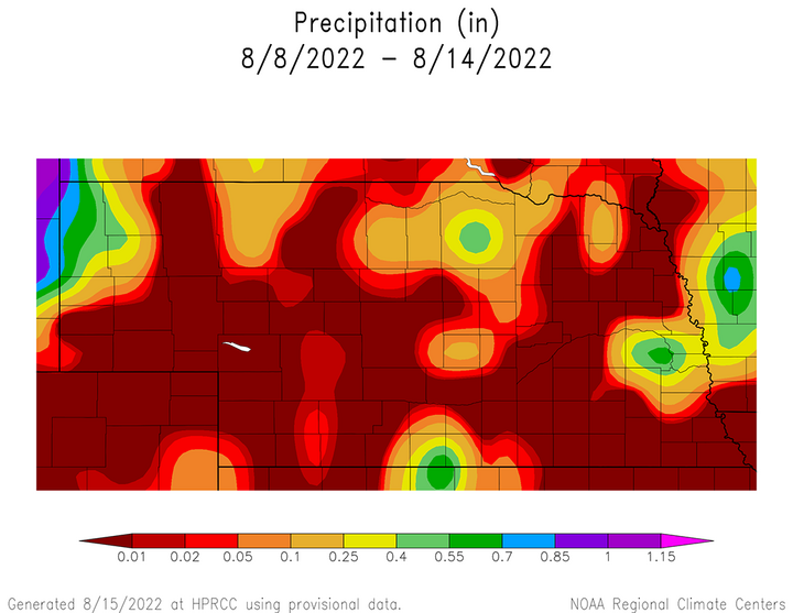
A surface cold front associated with an upper air trough crossing the northern Plains move slowly through the state Aug. 7-8. Scattered showers and thunderstorms developed along the front and were most concentrated in the central third of the state. Unfortunately, a considerable majority of eastern and western Nebraska rainfall reports ranged from zero to a quarter inch. More significant moisture fell after the analysis window used for this report and will be reflected in next week’s report.
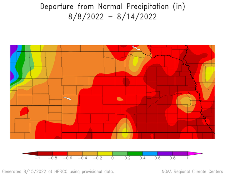
It is apparent from Figure 1 that precipitation coverage was sparse across the state Aug. 8-14. Areas that received more than 0.50 inches of rainfall were limited to parts of south-central and northeast Nebraska, as well as the northwestern Panhandle. When compared to what normally should be expected for this time of year, the southeastern half of the state recorded precipitation shortfalls ranging from 0.60 to 1.00 inches (Figure 2). The only widespread area to receive above-normal moisture was across northwestern Panhandle.


The daily maximum precipitation values reported from NERain observers are as follows: July 8 — 0.97 inches (Naponee 1.5 SW), July 9 — 0.14 inches (Springview 7.6 SSW), July 10— 0.11 inches (Elsie 9.7 SSE), July 11 — 0.00 inches (all locations), July 12 — Trace (Bayard 13.5 NNE, Dannebrog 0.4 WNW), July 13 — 0.83 inches (Scottsbluff 16.4 WNW), July 14 — 0.83 inches (Alliance 5.9 NE).
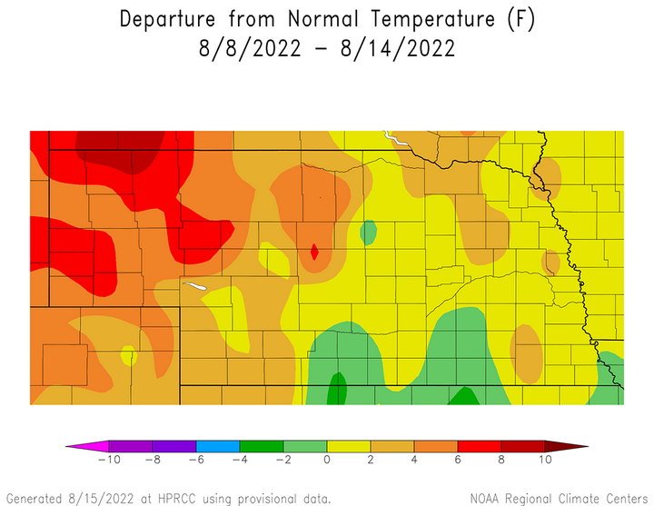
The lack of widespread moisture and return of high temperatures into the 90s to low 100s further stressed range and cropland. Average temperatures across the panhandle were 4-10°F above normal, with the strongest anomalies occurring along the Nebraska-South Dakota border region (Figure 3). Most of the eastern half of the state had average temperature anomalies ranging from normal to 4°F above normal. A small pocket of south-central Nebraska reported average temperature anomalies ranging from normal to 2°F below normal.

The daily maximum temperature extremes for airport location provided by the National Weather Service are as follows: July 8 — 97°F (Chadron), July 9 — 102°F (Chadron), July 10 — 104°F (Chadron), July 11 — 103°F (Chadron), July 12 — 102°F (McCook, O’Neill, Thedford), July 13 — 102 °F (McCook), July 14 — 102°F (McCook).
The daily minimum temperature extremes are as follows: July 8 — 49°F (Wayne), July 9 — 49°F (Wayne), July 10 — 56°F (Alliance), July 11 — 60°F (Alliance, Broken Bow, Falls City, North Platte, Ogallala), July 12 — 57°F (Alliance, Hebron, Holdrege), July 13 — 60°F (Imperial, Kimball), July 14 — 54°F (Wayne).
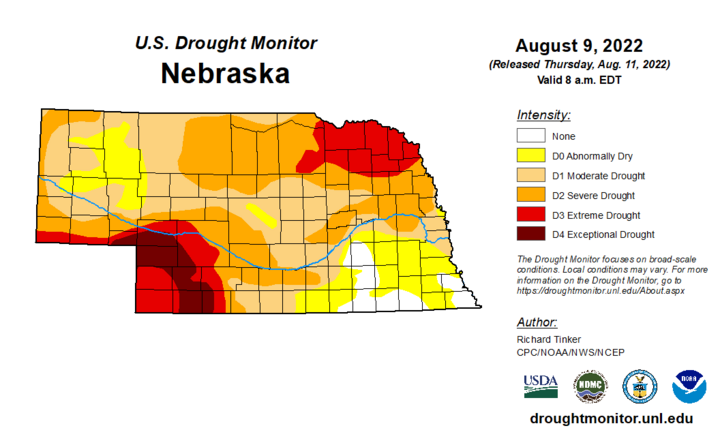
The combination of heat and dryness contributed to a further expansion of drought conditions into eastern Nebraska and drought intensification across southwest Nebraska. According to the latest U.S. Drought Monitor issued on Aug. 11 for conditions through 0800 CDT Aug. 9, exceptional drought (D4) has been expanded to cover a large portion of southwest Nebraska. Further east, abnormal dryness was expanded into most of the east-central and southeast areas of the state. Given the heat and dryness statewide through this past weekend, areas not receiving at least 0.50 inches of moisture on Aug. 9 were expected as most likely to see drought intensification in the next Drought Monitor, issued on Aug. 18.
Crop Progress
The lack of widespread rainfall last week, combined with above-normal temperatures across the western half of Nebraska, led to another week of crop condition declines according to the Nebraska Agricultural Statistics Service (NASS). The lack of moisture and above-normal temperatures during the past 30 days have been detrimental to corn and soybean yields. There have been widespread reports of soybeans dropping pods and corn fields firing, although the true impact to yields will not likely be known for a couple more weeks.
Western Nebraska endured a week of high temperatures in the 90s to low 100s with only small pockets of moisture exceeding 0.50 inches. University of Nebraska Extension educator reports indicate that grasshopper populations are increasing from a lack of rainfall, which may put further stress on drought-ravaged rangeland. NASS indicates that topsoil moisture as of Aug. 14 was rated 39% very poor, 39% poor, 22% adequate and 0% surplus. Subsoil moisture was rated 37% very poor, 39% poor, 24% adequate and 0% surplus.

Compared to conditions on Aug. 7, both topsoil and subsoil exhibited a strong movement regarding the percentage of the crop rated very poor. NASS data indicates there was a seven-percentage point increase in topsoil and subsoil conditions rated very poor. The increase in the percentage of topsoil rated very poor came from a three-percentage point decrease in the “short” category and a four-percentage point drop in the adequate category. The seven-point increase in subsoil moisture rated very poor came at the expense of a two-percentage point drop in subsoils rated short and a five-percentage point drop in subsoil moisture rated adequate.
The condition of the soybean crop deteriorated according to NASS. Soybeans rated good to excellent was 48%, compared to 54% on Aug. 7. Currently, NASS rates the soybean crop as 8% very poor, 12% poor, 32% fair, 38% good and 10% excellent. While the very poor and poor categories only increased one percentage point each compared to the previous week, there was a four-percentage point decline in fair category. Soybeans setting pods was estimated to be 88%, equal to last year and the five-year average of 82%.
Corn rated good to excellent was 47%, compared to 50% on Aug. 7. According to NASS, the current corn crop is rated 12% very poor, 14% poor, 27% fair, 36% good and 11% excellent. Compared to a week earlier, there was a one percentage point increase in the very poor rating, a two-percentage point increase in the poor rating, a four-percentage point drop in the good category and one-percentage point increase in the excellent category. NASS estimates that 64% of the crop was in the dough stage, which compares to 78% last year and the five-year average of 72%. Corn in the dent stage was estimated to be 17%, which compares to 16% last year and the five-year average of 18%.
Finally, pastures and rangeland condition rankings have been biased toward the negative side most of this growing season. With widespread daily maximum temperatures ranging from the 90s to low 100s last week and just isolated pockets of moisture exceeding 0.50 inches, there was a large percentage increase for rangeland/pastures rated as “very poor”. NASS estimates that as of Aug. 14, rangeland/pastures were rated 44% very poor, 29% poor, 30% fair, 5% good and 1% excellent. The net percentage change from Aug. 7 conditions are as follows: very poor (+11), poor (+1), fair (-9), good (-4) and excellent (+1).
Weather Outlook
The most current version of the GFS model issued the morning of Aug. 16 indicates that three distinct upper air troughs are forecast to have a bearing on Nebraska’s weather through the end of the month. The first trough is forecast to impact the state Thursday through Saturday and will keep temperatures below normal into the early part of next week. Another upper air trough is forecast to cross the northern Plains during the latter half of next week, with a third trough indicated for the end of the month.
Currently, the central High Plains is being dominated by high pressure aloft with high temperatures forecast to remain in the 80s east to low 90s west through Aug. 18. A weak mid-level atmospheric trough is forecast to slowly drift southward from northern Minnesota Aug. 19-21 and increase chances for rainfall across the eastern third of the state. Scattered showers may develop across northeast Nebraska beginning the evening of Aug. 18, with widespread precipitation likely Aug. 19. The GFS model pushes this moisture into east-central and southeast Nebraska as the day progresses, before ending precipitation during the first half of Aug. 20.
The bulk of moisture with this system is currently forecast to move across Iowa and quantitative precipitation forecasts indicate eastern Nebraska will receive less than 0.50 inches, unless thunderstorms can develop. Clouds will keep high temperatures in the 70s and low 80s east, but western Nebraska should see highs in the 80s with abundant sunshine. High pressure will build into the region behind the departing mid-level trough Aug. 21-24 with high temperatures warming from the 80s Aug. 21st into the low 90s by Aug. 24.
The GFS model indicates that an upper air trough will cross the northern Plains Aug. 24-26, then deepen over the western Great Lakes. A surface cold front is depicted by the GFS model to enter the northwestern corner of the state during the evening of Aug. 24. This front is forecast to slowly move southward and not reach the Kansas border until the morning of Aug. 26. The GFS model is indicating that scattered showers and thunderstorms will persist along the surface front the entire time it moves across the state, with the potential for some locations to receive 0.50-1.00 inches of moisture. High temperatures during the period will cool back into the upper 70s northeast to the middle 80s southwest.
As this upper air trough deepens over the Great Lakes, the GFS model indicates the western U.S. upper air ridge will strengthen and shift eastward toward the central Plains Aug. 27-29. High temperatures are forecast to warm back into the middle 80s to low 90s east and upper 80s to upper 90s west. The GFS model indicates another upper air trough will slide southeast from south-central Canada Aug. 29-31.
The GFS model forecasts this upper air trough to broaden out, which will allow cooler air to filter westward toward eastern Nebraska, but leave the western two-thirds of the state under the influence of ridging aloft. Thus, high temperatures are forecast to dip into the lower 80s east but remain in the upper 80s to middle 90s west.
There is some uncertainty with this upper air trough as the GFS model has been shifting its southerly movement between the Dakotas and the western Great Lakes region. If this trough does enter the northern Plains, then a much cooler and potentially wetter forecast would develop for the end of the month. However, the persistent pattern has been drier and warmer than normal, so the preferred forecast at this time is for this upper air trough to stay east of Nebraska.
