Weather Review
Since this is the first weekly agricultural weather update of 2022 to coincide with the Nebraska Agricultural Statistics Service (NASS) initial weekly crop progress report, this section will review the weather patterns that have intensified dryness issues across the western three-fourths of the state since last fall.
The vast majority of moisture that fell across the state during the final three months of 2021 occurred during the second half of October as several upper air troughs ejected out of the western United States. The most concentrated precipitation activity occurred east of a line from Norfolk to Lincoln, leaving most areas east of the Panhandle in the between the warm and cold frontal boundaries associated with the surface lows ejecting out of the southern Great Basin. With a strong upper air ridge situated over the eastern half of the United States, the track of these surface low pressure systems was to the north-northeast from southern Colorado to north central Minnesota. Surface winds across the central third of the state were consistently from the southwest, which created a dry slot of air between the warm front to the east and the cold fronts to the west.
At the end of December, a strong upper air low ejected out of the western United States and moved into the Great Lakes region, where it intensified the Hudson Bay upper air trough. This pattern locked into place for the better part of the next eight weeks. As a result, bitter cold air remained in place across eastern North Dakota, Minnesota, northern Iowa, Wisconsin and Michigan. Pieces of energy rotated around this trough, bringing frequent Alberta Clippers to the region.
Further west across the central and northern High Plains region (including Nebraska), above-normal temperatures were common during the first five weeks of 2022 before the Hudson Bay upper air trough began to expand westward. The final two-thirds of February into the first half of March were dominated by Alberta Clipper systems heading southeast across the western Dakotas, as they traveled along the backside of the upper air trough. These conditions resulted in below-normal temperatures, but a lack of surface moisture resulted in very light to no precipitation as each front passed through the state.
During the second half of March, the Hudson Bay upper air low weakened enough to allow upper air lows to move into the Pacific Northwest and these troughs began to move southeastward toward the southern High Plains region before turning northeast toward the lower Ohio River valley. Several strong surface lows developed and brought significant moisture to eastern Kansas, Oklahoma and Texas. Areas of east-central and southeast Nebraska were on the northern periphery of these surface lows and received above-normal moisture. However, areas northwest of a line from Omaha to Hebron were too far to the north of the surface lows and missed out on these valuable moisture events.
Thankfully, enough cold air has covered the central Plains during March to slow down vegetative dormancy break enough so that water demands are virtually non-existent presently. Therefore, there is still time for surface lows ejecting out of the western United States to provide rainfall prior to vegetative water demands kicking into high gear.
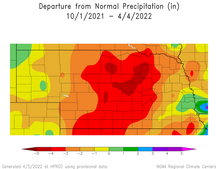
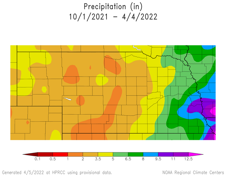
The accumulated precipitation deficits from the dry conditions across the northwestern three-fourths of the state for the past five months can be viewed in Figure 1. Unless a significant change in the precipitation pattern occurs prior to widespread warm season crop planting, drought conditions are likely to intensify rapidly once air temperatures begin to consistently move into the 80s. Expect frequent periods with a high danger of wildfires will continue until enough moisture occurs to promote grass growth combined with low temperatures exceeding 40°F on a regular basis. Low stock ponds, rivers and streams will continue until widespread thunderstorm activity develops, which for Nebraska normally during May and June.
Current Crop Conditions
The first weekly crop progress report issued by NASS on April 4 indicates that the winter wheat crop and soil moisture conditions deteriorated since the last weekly report of 2021 was issued on Nov. 28. This isn’t really earth-shattering news considering that a large portion of the wheat and pasture growing regions of the state failed to receive more than 3.5 inches of moisture since the soil moisture recharge period began at the beginning of last October.
NASS reports that the winter wheat condition as of April 3 is rated 7% very poor, 15% poor, 51% fair, 23% good and 4% excellent. The last weekly report of 2021 for crop conditions as of Nov. 27 indicated that the winter wheat crop was rated as 2% very poor, 11% poor, 23% fair, 52% good and 12% excellent. The net change in ratings over the past four months is an increase of five percentage points in the very poor category, a four-percentage point increase in the poor category, a 28-point decline in the fair category, a 29-percentage point decline in the good category and an eight percentage point decline in the excellent category.
Topsoil moisture conditions on Nov. 27 stood at 9% very short, 33% short, 58% adequate and 0% surplus. NASS reports that topsoil conditions as of April 3, 2022 stood at 33% very short, 48% short, 19% adequate and 0% surplus. Over the last four months, topsoil ratings increased 24 percentage points in the very short category and 15 percentage points in the short category. These increases occurred at the expense of the adequate category, which dropped 39 percentage points during the last four months.
Subsoil moisture conditions on Nov. 27 stood at 15% very short, 34% short, 50% adequate and 1% surplus. NASS reports the subsoil moisture conditions as of April 3, 2020 stood at 32% very short, 50% short, 18% adequate and 0% surplus. Over the last four months, subsoil moisture rated very short increased 17 percentage points and short category increased 16 percentage points. Subsoil moisture rated adequate dropped 32 percentage points, while the excellent category dropped one percentage point.
There was not rating given on pasture conditions for this week’s NASS crop progress report, but significant declines are expected given the dry conditions since the beginning of December. As of Nov. 27, pastures were rated 16% very poor, 20% poor, 46% fair, 15% good and 3% excellent.
The only planting information given by NASS for the first weekly crop progress report of 2022 was for oats. As of April 3, NASS estimates that 14% of the crop was planted compared to 16% last year and the five-year average of 14%.
Current Weather Outlook
The Climate Prediction Center (CPC) issued their preliminary April temperature and precipitation outlooks on March 17 (Figures 3 and 4), which indicated that below normal moisture and above normal temperatures were favored for Nebraska. CPC issued their official April outlook on March 31 (Figures 5 and 6), which pushed the below normal precipitation outlook south and west of Nebraska, while expanding the above normal moisture area from the Ohio River valley westward to just shy of the eastern Nebraska border. The temperature outlook continues to indicate above normal temperatures, but they reduced their confidence to the lowest probability level used in their forecasts.
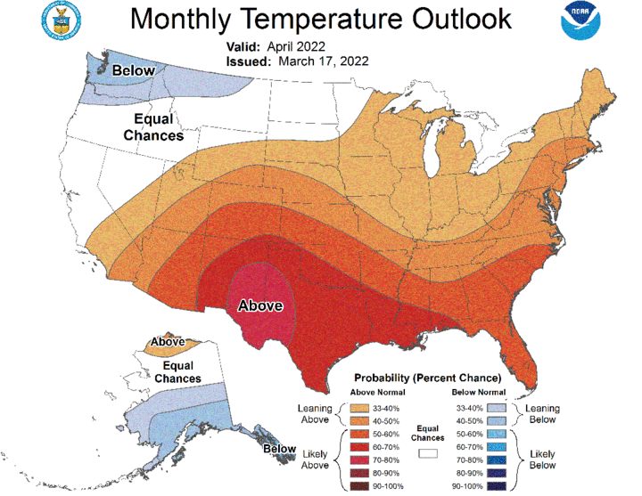
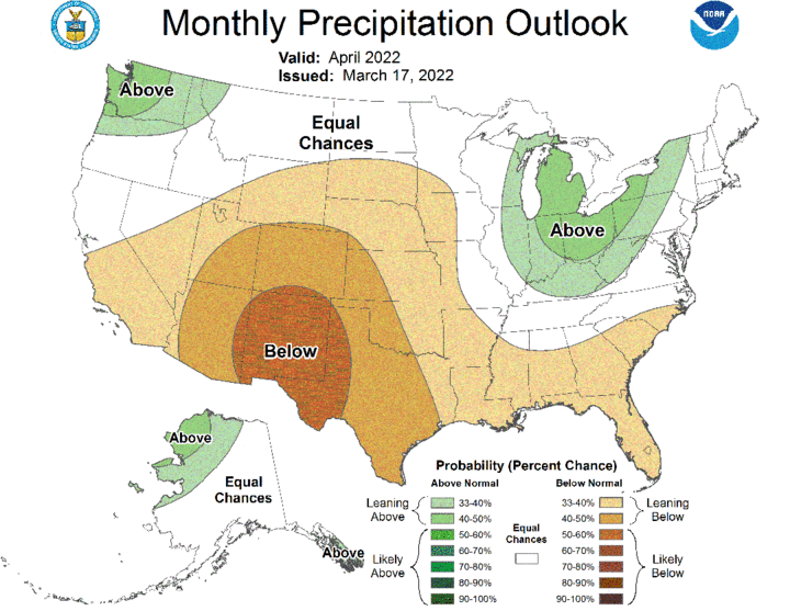
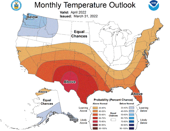
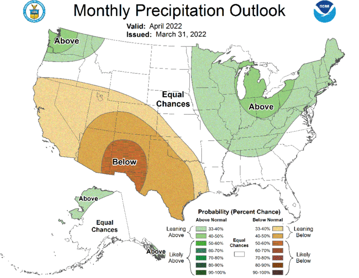
Although CPC is not indicating above normal precipitation statewide this month in their final outlook, they have backed away from their preliminary forecast for below normal moisture during April. It is not a drought-easing outlook, but it does back away from a forecast that would have likely resulted in the expansion and intensification of drought conditions by the end of the month.
With the April 10 crop insurance coverage period for corn rapidly approaching for the southeastern half of the state, the GFS model is indicating that temperatures may be cooler than desired to start the planting season and a least one significant storm system will develop across the central Plains region right at the beginning of the insurance replant coverage period.
The latest GFS model issued 12Z (6 am CST, 5 am MST) and precipitation outlooks currently signal that system currently impacting the state (April 5) with light rainfall will move east of the state and stall for several days over the upper Mississippi River valley. This will allow cold air to move around the backside of the upper air low and spread below normal temperatures into Nebraska, couple with a slight chance for light snow and/or rain showers across the northern tier of counties in north central and northeast Nebraska through April 7.
Temperatures are expected to warm into the 60’s this weekend, with 70’s and possibly low 80’s on Monday (April 10). The conditions would be in advance of an upper air trough moving through the Pacific Northwest this weekend. This trough is forecast to move through the central and northern High Plains region April 11-14. If the GFS model is correct, widespread rainfall would occur across the western two-thirds of the state April 11, possible changing to accumulating snowfall on April 12. Eastern Nebraska would likely seed isolated severe thunderstorms on April 11, with showers likely on the April 12.
If this system comes out in two pieces, then a second round of moisture would be favored for eastern Nebraska on April 15. If this system moves out of the western United States as a single trough, then western Nebraska would be favored to receive more significant snowfall on April 12. Normal temperatures are advertised to return to the state April 16-17, before another trough moves through the central Plains on April 18 and increases rain chances across the eastern half of Nebraska.
The GFS model then indicates rapid warming from April 18-21 (end of the GFS model run), which would likely lead to good corn planting weather. Another trough entering the Pacific Northwest at the end of the GFS model run would suggest that dry conditions should prevail at least through April 23, before that system impacts the central Plains with another precipitation opportunity.
