Check here for the latest in Nebraska weather.
Weather Review
Another strong storm system ejected out of the southern Great Basin and moved northeast into the eastern Dakotas this past week and brought another round of blizzard conditions to the eastern Montana, northeastern Wyoming, the western Dakotas and the northern fourth of the Nebraska Panhandle. South of this region, isolated pockets of rain and thunderstorms were reported across Nebraska.
Unfortunately, this precipitation was not widespread and not sufficient enough to reduce drought intensity or coverage across the state. The high winds that accompanied this system helped fuel another wildfire in southwestern Nebraska that has currently burned an estimated 41,000 acres from the Kansas border to just north of Cambridge. For the second time in 10 days, another life was lost battling the second major wildfire in Nebraska this year.
Air temperatures in advance of this past week’s storm system were above normal, before cooling significantly after the system moved toward the western Great Lakes region. High temperatures pushed into the 80s and 90s after the surface warm front lifted north of Nebraska, only to cool back into the upper 40s to low 60s this past weekend on the heels of strong northwesterly winds. The southern two-thirds of the state averaged 4-8°F above normal (Figure 1), with below-normal temperatures confined to pockets of northwest, north-central and northeast Nebraska. Across the northern third of the state, average temperature departures this past week generally ranged from 4°F above normal to 2°F below normal.
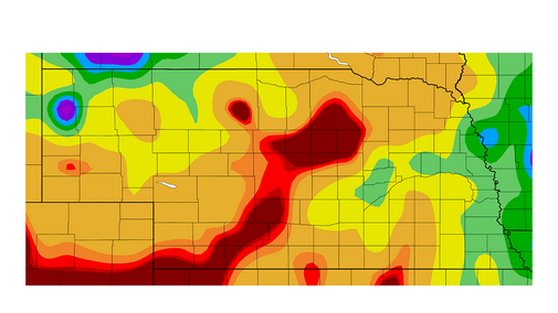
Precipitation reports from April 19 through April 25 (Figure 2) indicated that the most concentrated areas of moisture fell from the northern Panhandle into the northwestern Sandhill region, the southeastern corner of the Panhandle and northwest corner of southwest Nebraska, central Nebraska, as well as extreme southeast and northeast Nebraska. The precipitation bullseye over the Panhandle is erroneous and will be removed by the service provider once the data is run through quality control routines.
NERain observations indicate 0.25 to 1.10 inches of moisture were reported during this period across the northern Panhandle and northwestern Sandhills. Between 0.25 to 1.50 inches were reported from Grand Island to Columbus, as well as 0.25 to 1.00 inches across the southeastern Panhandle and northwestern corner of southwest Nebraska. The extreme southeastern corner of the state reported 0.25 to 0.70 inches of moisture, while extreme northeastern Nebraska reported 0.25 to 0.35 inches of moisture. For the remainder of the state, NERain observations ranged from nothing to just under a tenth of an inch of moisture.


Current Crop Conditions
Although planting this month is close to the five-year average for oats and corn, the lack of surface moisture coupled with below-normal temperatures has likely slowed down planting activity across the eastern two-thirds of Nebraska. There have been no major planting delays due to wet weather, but the continued push of cold air behind powerful storm systems crossing the northern Plains has resulted in persistently cool soil conditions most of April. Four-inch average bare soil temperatures have ranged from the low 40s to low 50s for much of the past two weeks. Figure 3 shows the average temperature departures since the beginning of April across the state. Northern and eastern Nebraska has averaged 2-5°F below normal, while the drier areas of southwest, south-central, and central Nebraska have averaged 2°F below normal to 1°F above normal.
Persistent below normal-moisture since the end of last October has continued through April for the vast majority of the state. The only areas of the state that have received at least 0.70 inches of moisture so far this month are pockets of the northern Panhandle, the northwest Sandhill region and the eastern half of east central and southeast Nebraska. A significant area including southwest, south-central, central and eastern north-central Nebraska have failed to receive a tenth of an inch of moisture this month. The bullseye in the Panhandle that appears in Figure 4 is a data entry error that will be corrected by the map originators in the near future when quality control programs can compare it to surrounding locations that have yet to report their data through the National Weather Service.


The lack of surface moisture and cool soil temperatures are likely contributing to planting delays across Nebraska. According to the Nebraska Agricultural Statistics Service (NASS), there were 5.8 days suitable for field work. Corn planting reached 10% complete as of April 24, which is ahead of last year’s pace of 5%, but near the five-year average of 11%. Oat planting was 79% complete, behind last year’s pace of 84% complete, but ahead of the five-year average of 66%. Only 32% of the oat crop had emerged, near the five-year average of 28%, but behind last year’s pace of 39%. Dry surface conditions across north-central and northeast Nebraska may be contributing to a slower emergence pace than last year.
There was no information on pasture conditions across the state in this week’s NASS release, but further deterioration was likely for areas that failed to receive moisture this past week, especially with the strong winds reported statewide April 21-24. NASS reports that the winter wheat condition was rated 14% very poor, 18% poor, 44% fair, 21% good and 2% excellent. The very poor category increased 4 percentage points from conditions through April 17 and increased 1 percentage point for the poor category. NASS reports that the fair category dropped 2 percentage points, while the good category decreased 4 percentage points.
Surface and subsurface moisture supplies continue to reflect an absence of widespread soaking precipitation. Surface moisture supplies as of April 24 were rated 45% very short, 37% short, 18% adequate and 0% surplus. The very poor and poor categories improved one percentage point from the prior week, while the adequate category increased 2 percentage points. Subsoil moisture supplies were rated 40% very short, 44% short, 16% adequate and 0% surplus. Compared to conditions as of April 17, the very short category improved 1 percentage points, while the short category increased 2 percentage points and the adequate category declined one percentage point.
Current Weather Outlook
The GFS model run the morning of April 26 indicates that another strong upper air low will move into the northern half of the High Plains region April 29-30. The quantitative precipitation forecast for this event has gradually shifted the expected precipitation band southward the past three days. The most recent forecast has shifted the one- to two-inch moisture band from western North and South Dakota southward to include the northern half of the Panhandle, as well as north-central Nebraska. More importantly, predicted moisture for southwest and south-central Nebraska has increased from under a tenth of an inch April 22 to an inch currently. Precipitation forecasted for the eastern half of the state has been more consistent over the past five days, with 0.75-1.25 inches forecast.
Before the strong upper air trough moves into the High Plains, the GFS model indicates that a weak trough will move just south of the state the evening of April 27 into the first half of April 28. The best opportunity for moisture is indicated for the southeastern quarter of the state with general coverage of 0.10 to 0.25 inches currently forecasted, with highest totals expected near the Kansas border. The strong trough at the end of this week is expected to begin generating precipitation across the western third of the state during the first half of April 29, then expand eastward during the day. The system will slowly move northeast toward southern Minnesota on April 30 and generate widespread moisture across the eastern half of the state. Although moisture is forecast to end across western Nebraska by the second half of day, 0.25–0.50 inches of additional moisture is possible.
High temperatures are forecast to primarily be in the 60s from May 1-8 as a series of troughs move across the central Plains. The GFS model indicates that the first system will move across the state May 2-3, with precipitation totals forecast to be in the 0.25- to 0.50-inch range. Another quick moving system pushes through the state May 6, with precipitation totals generally under a quarter inch. Another powerful trough is forecast to cross the northern half of the High Plains May 7-8. The northern half of Nebraska currently is forecast to receive the heaviest precipitation and based upon the forecasted strength of this system, rain and thunderstorms could produce another 0.50 to 1.00 inches of moisture. Across the southern half of Nebraska, modelled precipitation intensity would indicate that 0.25-0.50 inches of moisture are possible.
A warming trend is indicated by the GFS model for May 9-11 before another trough is forecast to move across the northern Plains on May 12. Currently the GFS model keeps northern Nebraska on the southern periphery of this system — if it verifies, it would keep daily high temperatures in the 70-80°F range. If this system tracks further south, then high temperatures will drop back into the mid-50s to middle 60s. A very strong upper air low is forecast to move on to the west coast May 12-13 and gradually work eastward. This would push an upper air ridge into the central U.S. May 13-16 and result in widespread high temperatures moving into the upper 70s to upper 80s.
