Weather Review
Weather conditions during the past week were primarily influenced by a strong upper air low that ejected out of the southern Rockies and moved northeast toward the northern High Plains. As the system intensified into a blizzard across most of North Dakota and eastern Montana, it forced a cold front through Nebraska on April 13. Rapid thunderstorm development occurred along the front during the early evening hours and produced the first two confirmed tornado touchdowns of 2022. Storm spotters reported a tornado reached the ground a couple miles southwest of Seward and near Unadilla.
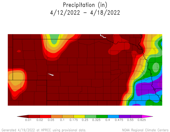
Precipitation reports from NErain observers indicated that between 0.25 and 0.75 inches of rain fell east of a line from Fairbury to Fremont, with the heaviest totals occurring across Sarpy, Otoe, Nemaha and Richardson counties. West of the front, dry air inhibited precipitation formation and precipitation was non-existent east of the Panhandle. The northern half of the Panhandle received anywhere from trace amounts to nearly four-tenths of an inch near Chadron. Cumulative weekly precipitation totals from April 12-18 can be found in Figure 1.

Air temperatures on April 13 rose from the 40s prior to the warm front lifting north, then quickly rose into the 80s and low 90s across central and eastern Nebraska prior to the arrival of the cold front. However, maximum daily high temperatures hovered in the 40s and 50s Monday, Wednesday and Thursday across the western half of the state. High temperatures across the eastern one-fourth of Nebraska remained in the 50s through the weekend, but areas west of York had high temperatures reach the 60s both Saturday and Sunday.
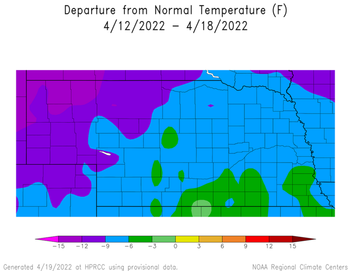
Unfortunately, low temperatures were persistently in the 20s and 30s for most of the period and four-inch bare soil temperatures remained in the upper 30s to middle 40s statewide. Average temperatures statewide were 15-20°F below normal last Monday, Wednesday and Thursday. Across eastern Nebraska, these cold departures lasted into the first half of the weekend. Figure 2 shows the cumulative impacts of this cold stretch of weather largely influenced by the cold air wrapping around the upper-level low that brought the strong blizzard to the northern High Plains.
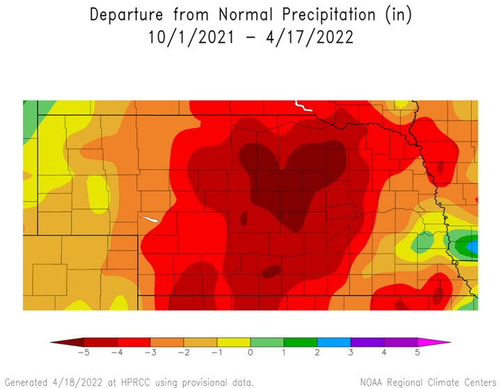
With the continuation of dry weather this spring west and north of east-central and southeast Nebraska, cumulative precipitation deficits for the soil recharge period (Oct. 1–present) continue to grow and expand as we approach the climatologically wettest months of the year (May, June, July). Figure 3 indicates that most of southwest, south-central, central, north-central and northeast Nebraska have soil water recharge period rainfall deficits of three inches or greater. Within this area, precipitation deficits are now greater than five inches across the central Sandhill region, with four- to five-inch deficits across the eastern and western Sandhill region, along with central, south-central and the eastern half of southwest Nebraska.


Current Crop Conditions
As would be expected with the lack of measurable moisture this past week for a large portion of the state, topsoil and subsoil moisture ratings continued to decline according to the Nebraska Agricultural Statistics Service (NASS) weekly crop report of conditions as of April 18. Topsoil moisture supplies were rated 46% very short, 28% short, 16% adequate and 0% surplus. Subsoil moisture supplies were rated 41% very short, 42% short, 17% adequate and 2% excellent. Both topsoil and subsoil moisture levels in the very short and short categories expanded 3-5 percentage points compared to the NASS crop report issued on April 12.
Winter wheat continued to deteriorate, which was expected considering that most of the primary wheat growing regions of the state (Panhandle, southwest and south-central) failed to receive measurable moisture this past week. According to NASS, the wheat condition on April 18 was rated 10% very poor, 17% poor, 46% fair, 25% good and 2% excellent. Compared to conditions as of April 11, winter wheat rated very poor increased two percentage points, while wheat rated poor increased three percentage points. The fair rating remained unchanged, while the good category fell four percentage points and the excellent rating fell one percentage point.
Oat seeding was estimated to be 58% complete as of April 18, which compares to 66% complete last year and the five-year average of 49%. Emergence was estimated to be 12%, which is behind last year’s pace of 23% and the five-year average of 14%. With below-normal temperatures keeping four-inch bare soil temperatures confined to the upper 30s north to middle 40s south, little corn planting progress was noted. Additionally, the lack of surface moisture available within the planting zone likely contributed to the slow start to planting. NASS reports that 2% of the corn crop had been planted as of April 18, which is equal to last year and the five-year average. This pace should increase with signs that a warmer temperature pattern will begin to develop the second half of this week.
Current Weather Outlook
The most recent GFS model run issued the morning of April 19 indicated that a trough would move across the northern High Plains region on April 20 and bring a chance of scattered showers and maybe a few rumbles of thunder to the eastern two tiers of counties. Total precipitation output was forecast to be less than 0.10 inches of moisture. Further to the north, accumulating snowfall was likely for eastern Montana and western North Dakota, which received 20-36 inches of snowfall with last week’s blizzard and another 4-10 inches this past weekend. At present, the GFS does not bring substantial cold air into Nebraska, so high temperatures were expected to be in the 50s to 60s across the state.
As this system passes to our east, a strong upper air trough will enter the northern half of California on April 21, then head northeast toward the northern Plains. This will push a ridge toward the central United States April 21-22. High temperatures are forecast to rise into the 70s on April 21 and 80s on April 22. As the surface low moves from the southern Rockies into the northern Plains April 22-24, the Storm Prediction Center currently indicates that severe thunderstorms may develop somewhere across the eastern half of Nebraska during the second half of April 22. Light shower activity is possible on April 23 after the cold front shifts east of the state. Further to our north, another significant snowstorm is likely for western North Dakota and eastern Montana.
As the cold air wraps around the surface low forecasted to be over eastern North Dakota on April 25, high temperatures over the northern one-third of Nebraska may drop into the upper 40s to low 50s April 24-25. The GFS model indicates a warming trend will develop April 26-27, with high temperatures moving into the 70s, with lower 80s possible in the drier areas of central and western Nebraska. A weak upper air trough is forecasts to move across the northern Plains April 27-28 and the GFS model indicates that moisture across Nebraska will once again be confined to the eastern most counties. High temperatures are forecast to cool back into the 60s on April 28, before warming back into the 70s to low 80s from April 29-May 1.
The remaining four days in the GFS model run indicates that a weak trough will cross the northern Plains on May 2, which would leave Nebraska south of the primary precipitation band. If the GFS is correct, then any moisture that falls across Nebraska will be along the Missouri river into western Iowa. Atmospheric ridging if forecast across the central Plains May 3-5, with an upper air trough building into the northern half of the Rocky Mountains. Based upon the current forecasted movement of this system, it wouldn’t likely move into the central and northern High Plains around May 6-7.
