Weather Review
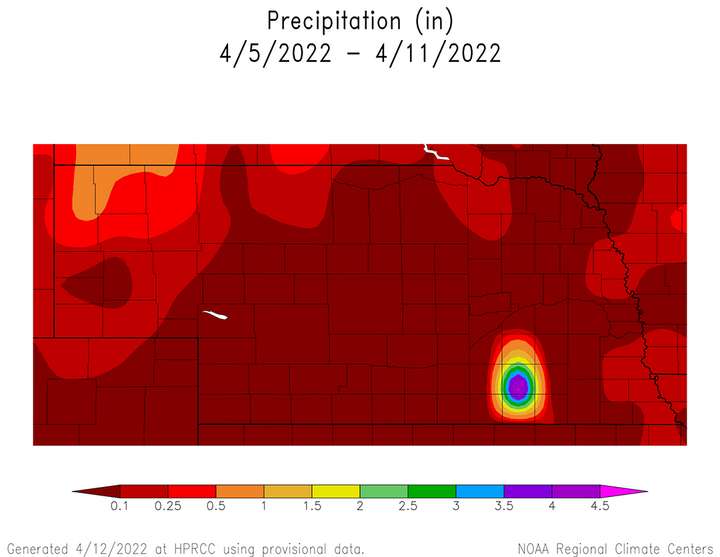
Cooler than normal temperatures and below-normal precipitation were the dominate features across most of the state over the past week. Maximum temperatures remained in the 40s and 50s from April 6-9 due to strong northwesterly winds wrapping around a slow-moving upper air trough that crossed the northern Plains and stalled over the western Great Lakes region. As this system emerged out of the northern Rockies, the northern third of the Panhandle reported precipitation ranging from 0.10–0.60 inches. The remainder of the state received nothing to less than 0.20 inches of moisture, primarily the result of scattered snow and rain showers moving southward on the backside of the upper air low.
Figure 1 shows the precipitation distribution across the state from April 5-11, and it is apparent how small the area was that received more than one-half of an inch of moisture across the northern Panhandle. It should be noted that the bullseye of moisture that appears over south-central Nebraska is not a valid observation and has yet to be removed from the database used to create the weekly precipitation maps.

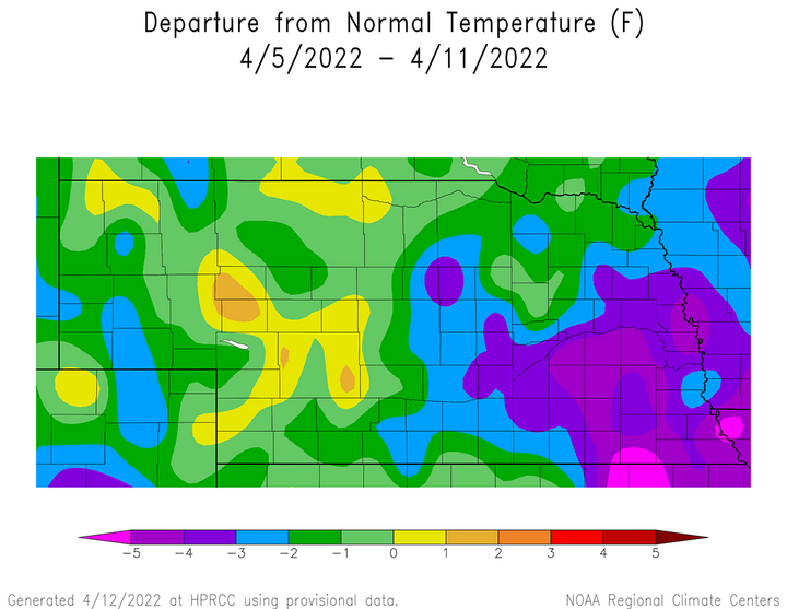
Figure 2 indicates that most of the state received below-normal temperatures for the week, with the largest temperature departures occurring across south-central, southeast and east-central Nebraska. The largest daily average temperature departure from normal occurred on April 8 when high temperatures across eastern Nebraska ranged from the upper 30s in the northeast to the upper 40s in the southeast.

Perhaps the most significant issue that occurred during this past week was the strong winds that buffeted the state April 7-8. Unfortunately, it was these strong winds that blew down power lines in the Elwood area and sparked a fast-moving rangeland fire that consumed an estimated 30,000 acres. One fatality occurred when two vehicles driven by firefighter volunteers collided with each other while driving through smoke laden with visibilities approaching zero. At least eight homes were destroyed according to preliminary reports and these totals may increase once a complete damage assessment is issued by the state fire marshal’s office.
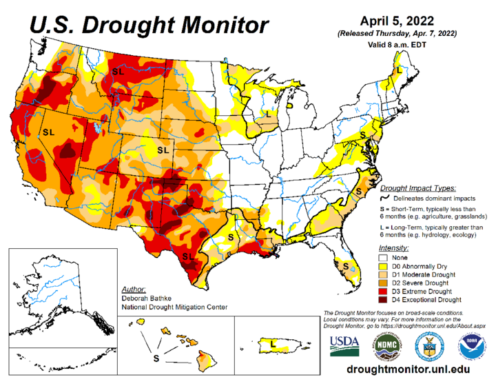
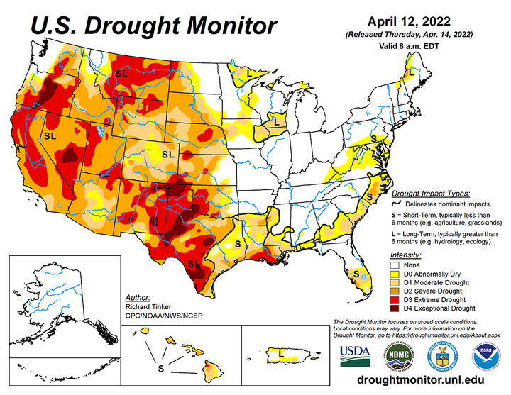
The dry conditions further intensified drought conditions across parts of central Nebraska. Extreme drought conditions (D3) were expanded across the south-central Sandhill region, while severe drought conditions (D2) were increased across southwest, south-central, northeast and central Nebraska. Figure 3 depicts the U.S. Drought Monitor for conditions through 7 a.m. CST. April 5. Figure 4 depicts the U.S. Drought Monitor for conditions through 7 a.m. CST. April 12.


Current Crop Conditions
According to the Nebraska Agricultural Statistics Service (NASS) crop report issued April 11 for condition through April 10, topsoil and subsoil moisture ratings declined during the past week. Topsoil moisture supplies were rated 41% very short, 39% short, 20% adequate and 0% surplus. NASS reports that topsoil in the very short category increased eight percentage points, while the short category increased nine percentage points compared to the April 4 report. Subsoil moisture ratings also declined, with NASS reporting 37% very short, 45% short, 18% adequate and 0% surplus. Compared to the April 4 report, the very short and short categories both increased five percentage points, while the adequate rating did not change.
With the lack of moisture during the past week, oat planting increased to 44% complete as of April 11, compared to the five-year average of 28%. At this time last year, oat planting was 37% complete. Oat emergence was estimated to be 6%, compared to 7% last year and the five-year average of 4%. Winter wheat conditions were rated 8% very poor, 14% poor, 46% fair, 29% good and 3% excellent. Compared to the April 4 NASS crop report, the biggest ratings change was a six-percentage point increase in the good rating, which came from a five-percentage point drop in the fair rating. With such dry conditions over the past week, the surprising crop rating improvement may just be a reflection of wheat breaking dormancy and beginning to green up across the Panhandle region.
Current Weather Outlook
A potent upper air trough was moving through the central and northern Plains at the time this report was being developed. Blizzard warnings were in place across eastern Montana, most of North Dakota, northwestern South Dakota and northeastern Wyoming. Snowfall totals of 12-30 inches (location dependent) are presently forecast, with winds in the 40-60 mph range. Liquid equivalent moisture is projected to be in the one- to three-inch range. With calving season in progress across this region, losses are expected, but it also bringing valuable moisture to areas that missed out on the generous fall moisture that was received across eastern North Dakota and northern Minnesota. Further to the south, severe thunderstorms were expected to develop across the eastern third of Nebraska with an elevated risk for widespread tornadic activity across northern Iowa.
The morning model run of the GFS issued on April 12 forecasts that the upper air trough over the northern Plains responsible for blizzard conditions and severe weather further south will migrate toward the Great Lakes by April 14. This movement is expected to initiate a widespread severe weather event for the eastern half of the Corn Belt, as well as the mid-Mississippi and lower Ohio river valleys on April 13. Further to the north, accumulating snowfall is forecast for the northern Great Lakes (Wisconsin and Michigan). Nebraska will be on the backside of this departing trough and will see below-normal temperatures with highs in the 40s and 50s through April 16 before a warming trend develops with high temperatures approaching the middle 60s by April 18.
A quick moving upper air trough is forecast to move across the northern Rockies April 17-18, leaving Nebraska south of the projected precipitation band. As the system heads toward the Great Lakes on April 19, the GFS model hints that northeastern Nebraska may see a few isolated showers due to the surface low diving southeast across northern Iowa. For the remainder of the state, a brief one-day cooldown is forecast with highs dropping back into the middle 50s. Another upper air trough is forecast to move across Montana and North Dakota April 20-21, but does not currently forecast precipitation across Nebraska.
Dry weather with seasonal temperatures is forecast for Nebraska April 20-21, with a strong warming trend indicated for the central Plains April 22-24. This is due to the GFS model indicating the development of an upper air trough entering the west coast, centered on northern California. This upper air trough is then forecast to move into the central United States April 23-25, with severe weather likely to develop from the Texas Panhandle northward through the western Sandhills of Nebraska on April 23 if the forecast verifies. On April 24, the GFS model shifts the severe weather into eastern Texas northward through eastern Nebraska, then weakening the system as it moves it into Missouri and Iowa. There will likely be changes in this forecasted event, but from a precipitation standpoint, this storm is the only significant moisture event currently forecast for Nebraska over the next 16 days.
It currently appears that the most favorable planting windows based upon widespread high temperatures exceeding 60°F would currently be April 19-24. If the April 23-25 storm system shifts northward like the current storm impacting the central Plains, then this planting window would likely expand at least an additional five days. However, if the GFS does verify, then some planting delays would be likely April 24-27 due to rainfall and the subsequent surface drying needed to minimize compaction from wet topsoil conditions.
