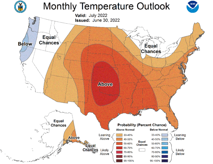
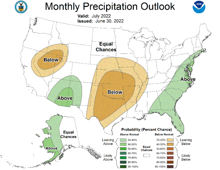
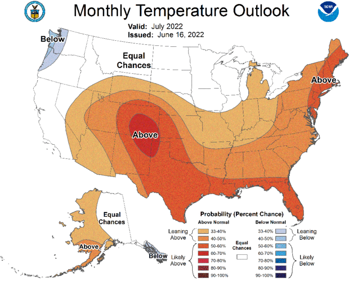
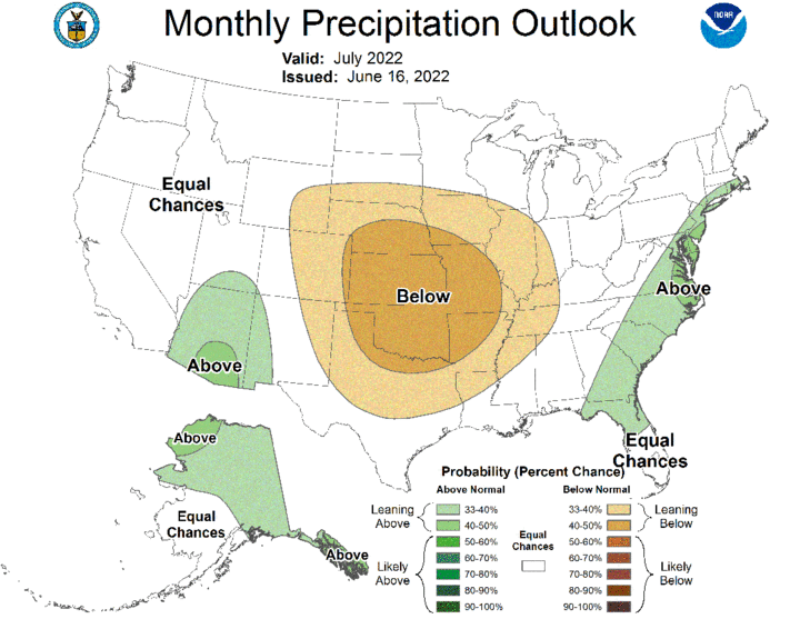
The Climate Prediction Center (CPC) released their official temperature and precipitation outlooks for July on June 30, which replaces their preliminary July outlooks issued June 16. The updated July outlooks indicate that Nebraska is forecast to receive above-normal temperatures (Figure 1) and below-normal precipitation (Figure 2). A comparison between the preliminary (Figures 3-4) and final July temperature and precipitation outlooks reveal that CPC has increased the odds for above-normal temperatures across Nebraska but has decreased the odds of below-normal precipitation.


The southward shift in CPC’s July precipitation outlook is likely a result of the current atmospheric pattern that is pulling monsoon moisture northward through the central Rockies and shunting it eastward into the central and northern Plains. These monsoonal moisture events are notoriously difficult to predict in regard to placement because they often develop from weak waves moving eastward out of the Rocky Mountains in the mid-layers of the atmosphere.
Since 2008, the National Weather Service had defined the southwestern United States monsoon season as the period between June 15 and Sept. 30. Previous to this definition, individual locations in Arizona and New Mexico used three consecutive days of dew point temperatures exceeding a defined value, usually near 55°F. The average date of the monsoon varies by location, but data from the University of Arizona indicates that it falls within the first two weeks of July two out of every three years.
This year, monsoon moisture and related thunderstorm activity began in mid-June across the eastern half of New Mexico and has expanded westward to include the eastern half of Arizona during the last week. This monsoonal moisture has been lifted northward on the backside of the upper air ridge centered over central and southern Texas, but it has also been aided by upper air troughs entering the Pacific Northwest and drawing moisture northward as it advances across the northern Rockies. As these upper air troughs progressed eastward, they were able to flatten out the southern Plains ridge and direct the monsoon moisture between the two competing air masses.
If this monsoon moisture is to have an impact on the central Plains, the upper air troughs that have moved through the Pacific Northwest and northern half of the Rockies will need to continue through the next two months. These troughs must deepen sufficiently east of the Rocky Mountains to flatten out the top of the Southern Plains upper air ridge so that monsoonal moisture can move northward through the central Rockies. The eastward movement of this moisture feed will be determined by how far south these upper air troughs can extend once they pass across the northern High Plains and south-central Canada.
If these upper air troughs develop southward into the Nebraska/Kansas region, precipitation events that develop from pieces of energy rotating through the central Rockies would be enhanced. This is the pattern that is currently being depicted by weather models for the first full week of July. If the southern Plains upper air ridge strengthens as we progress through July and upper air troughs can’t penetrate further south than the Dakotas, monsoonal moisture will be pulled northward into northern Wyoming and southern Montana before being deflected eastward. This would leave Nebraska south of the primary precipitation path and increase the likelihood that ongoing drought conditions across the state intensify and expand eastward.
So far this growing season, the upper air ridge to our south has been unable to build north and northwestward from the southern Plains and block the movement of upper air troughs moving into the Pacific Northwest for more than a week at a time. This may be due to the strength of these troughs in April and May that brought cold temperatures and significant snowfall to the northern Rockies. There still remains a substantial snowpack across this region, which has limited the expansion of the southern Plains upper air ridge into the northern Great Basin and the southern Canadian Rocky Mountains.
If the upper air ridge is to expand into the northern Rockies and block the movement of upper air troughs into the Pacific Northwest, then an upper air trough would be favored downstream of the high-pressure ridge. It would support a deeper Hudson Bay upper air trough and its mean position would determine where surface systems would move on its western flank. This type of pattern usually drives surface-based systems in a northwest to southeast direction. It also supports linear lines of thunderstorms that can bring high winds and hail to those caught in the path of these thunderstorm complexes.
Unfortunately, this type of pattern also pulls drier Canadian air southward after the surface system moves east and south of a given area. When precipitation fails to materialize, the drier air behind the surface-based front rapidly heats up as the upper air ridge builds back into the region. The drier and warmer air increases crop water demands, and if soil moisture is insufficient, crop stress quickly develops.
In short, warm-season dryland crop yield prospects will be dependent on timely precipitation events for the remainder of the growing season. This is especially true for northeast Nebraska, which missed out on the generous moisture that fell across southeastern Nebraska from mid-April through mid-June. If monsoon moisture continues to interact with upper air troughs moving across the northern Plains, there is a good chance that precipitation across Nebraska will be more widespread than the official CPC July outlook infers.
However, if the upper air ridge over the southern Plains continues to expand northward and shunts monsoonal moisture into the northern Rockies, drought conditions will likely expand and intensify across the central Plains as we progress through the month of July. Our precipitation chances would then be more dependent on systems moving southeast out of the northern Plains and south-central Canada, which is not a pattern that typically favors widespread moisture across the western two-thirds of Nebraska.
