The lack of subsoil moisture recharge, which relies on precipitation from October through April, was a strong contributing factor in regard to the intensity of drought conditions experienced across Nebraska and surrounding states during the 2022 cropping season. It is a normal occurrence during the growing season to have short periods of dry weather (less than two weeks) and crop stress can be minimized if adequate soil moisture exists to sustain a crop until precipitation develops. Unfortunately, most of Nebraska received extended periods (greater than two weeks) of dry weather during the critical grain filling stages for warm-season crops during July and August and there was an insufficient supply of stored soil water to get crops to the finish line without enduring drought stress.
Precipitation has been well below normal this fall and it will take an aggressive precipitation pattern through this winter and next spring to eliminate the precipitation deficits that have accumulated across the state this fall. Although recent storm activity has been strong across parts of the United States, these systems have either passed north or south of Nebraska resulting in dry frontal passages or very light precipitation totals. This article will attempt to quantify the impacts of our dry fall, what it will take to eliminate current soil moisture deficits and look forward to what climatological factors are most likely to impact the 2023 growing season across the United States. Several key points will be addressed:
- Precipitation was below normal this fall across the High Plains, Midwest and Great Lakes.
- Storm activity across the western United States appears to be increasing.
- La Niña conditions are forecast to dissipate by late spring bringing an end to this three-year event.
Fall Precipitation Anomalies — National Perspective
The fall season started out drier than normal across most of the country east of the Rockies (Figure 1) as the upper air ridge that dominated the second half of the summer across the western Corn Belt continued through the first three weeks of September. The most concentrated area of below-normal moisture was located across eastern Kansas and Oklahoma. Above-normal moisture was most prevalent from the southwestern United States through the northern Great Basin, the southern half of Florida (tropical activity) and the New England region.
A strong upper air low entered the Pacific Northwest the final 10 days of September and brought significant precipitation to California. This system pushed the upper air ridge east of the central United States and allowed the California system to push northeastward toward the northern Rockies. The atmospheric ridge dominated the eastern United States during the first half of October, which effectively blocked the movement of low-pressure systems through the central and eastern Corn Belt.
Precipitation anomalies from October (Figure 2) indicate that above-normal moisture was most concentrated across the Southwest Desert region and the northern Rockies. Below-normal precipitation anomalies dominated the remainder of the country. These anomalies were most intense across the Gulf of Mexico states, as well as the region encompassing the intersection of the Ohio and Mississippi Rivers. Low river flows on the southern half of the Mississippi River developed and lead to reduced barge traffic due to shallow channels creating inadequate drafting depth.


A more active weather pattern began to unfold during the month of November across the United States. Atmospheric troughs were entering the Pacific Northwest on a regular basis, brought above-normal moisture to southern California and the northern two-thirds of the Great Basin. Unfortunately for Nebraska, a strong northern jet carved out an upper air trough over the northern Plains and western Great Lakes. Therefore, atmospheric troughs moving through the southern Great Basin were forced eastward across the southern Plains and southeastern United States, instead of lifting northeast toward the central and northern High Plains region.

When the cumulative impacts of precipitation anomalies from the individual monthly components are taken into consideration (Figure 4), it is obvious that most areas between the Rocky Mountains and Alleghany Mountains were drier than normal. Fall precipitation deficits of six to nine inches have accumulated in the region encompassing the intersection of the Ohio and Mississippi River. Precipitation deficits of three to six inches have accumulated in the eastern Dakotas, eastern Nebraska, southern Minnesota, northwest half of Iowa, southeastern Kansas and northern Oklahoma.
Soil Moisture Recharge — Nebraska
If we scale down the national perspective to Nebraska, a more precise picture of our fall precipitation totals and accumulated anomalies materializes. Figure 5 indicates that cumulative fall precipitation exceeded 2.50 inches of liquid equivalent moisture for parts of south-central and southeast Nebraska, as well as the southeastern corner of the Sandhill region. Within these areas, only the extreme southeastern corner of Nebraska and a small pocket of the southeastern Sandhill region exceeded four inches of moisture.
For the remainder of the state, accumulated fall liquid equivalent moisture was between an inch and 2.50 inches. I highly suspect that the bullseye that appears in the western Sandhill region is anomalous and doesn’t have a serially complete precipitation measurements when compared to nearby NERain observers. Although not presented for your viewing pleasure, fall moisture was between 25% and 50% of normal in these drier areas. Locations exceeding 2.50 inches were 50% to 75% of normal.
Accumulated precipitation deficits this fall are depicted in Figure 6. Areas of eastern Nebraska depicted with bright red shading have accumulated fall precipitation deficits of three to four inches, while maroon shaded areas have deficits of four to five inches. Across western Nebraska, fall precipitation deficits are generally between one to three inches. In order to eliminate these fall precipitation deficits before the end of this winter, we will need to receive at least double our normally expected liquid equivalent moisture.


Let’s look at how much snow would be required over the next three months to eliminate precipitation deficits accumulated this past fall. Normal snow to water ratios are 10 to 1 across eastern Nebraska, which means 10 inches of average snow will equate to one inch of moisture. For the western half of Nebraska, snowfall is drier and it takes 12-15 inches of snow to generate an inch of water. Therefore, most of eastern Nebraska would need 30-40 inches of snow in addition to what normally falls during the winter months to eliminate 2022 fall precipitation deficits. For western Nebraska, an additional 15-30 inches of snowfall beyond normal accumulations would be required.
The effectiveness of any winter snowfall that we receive will be dependent on whether soils are frozen prior to individual events. Snowfall on frozen ground will primarily impact rivers, streams and ponds through surface runoff when melting occurs. There would be little impact on soil moisture retention unless they remain unfrozen prior to and after each individual snow event. A much easier hill to climb, so to speak, would be to gradually reduce these accumulated fall precipitation deficits to zero by the end of April. Using this scenario, it would take 130% of normal (Panhandle) to 150% of normal (east-central) to bring fall-spring soil moisture recharge back to normal by May 1.
Winter–Spring Weather Pattern Thoughts
We are currently in the third consecutive year of La Niña conditions, which has only happened three other times since the early 1950s. I expected the second year of La Niña conditions to end this past spring, just like most second year La Niña events do. I suspect that the Tonga eruptions that began in December 2021 and culminated in the massive explosion on Jan. 15, 2022 may have placed enough aerosols into the atmosphere to impede surface warming in the southern Pacific Ocean, which ultimately contributed to continued surface cooling in the eastern Equatorial Pacific and sustained this La Niña event this year.
La Niña conditions develop when the circulation pattern over Equatorial Pacific are stronger than normal by increasing the strength of westward moving surface winds, which in turn pushes the colder waters off of Peru further westward than normal. It also increases the strength of upwelling currents along the west coast of South America that transports Antarctica northward along the western coast South America. Typically, La Niña events end when the counter current under the Equatorial Pacific moves enough heat from the western Pacific to the eastern Pacific that it impedes upwelling and weakens the eastern Equatorial Pacific atmospheric pressure patterns. If these pressure patterns weaken sufficiently, westerly surface winds will relax enough to develop anomalous surface warmth that is the hallmark of El Niño conditions.

Figure 7 depicts the current global sea surface temperature anomalies, and it is evident that a large anomalous area of below-normal sea surface temperatures (blue shading) currently covers the eastern three-fourths of the Equatorial Pacific, which is the hallmark signature of a La Niña event. We are unable to post a 30-day animation of sea surface temperature anomalies due to the size of the graphics file, but there are signs that eastern portions of the surface cold pool are beginning to weaken. The ultimate question is whether this recent trend is signaling the beginning stages of La Niña’s eventual demise or just another head fake like we experienced this past spring.
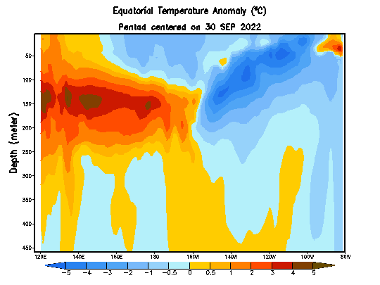
There is a strong anomalous warm pool underneath of the western half of the Equatorial Pacific basin that is showing signs of building into the eastern half of the basin (Figure 8). If this current can make it to the surface and not be canceled out by renewed upwelling of cold water off of the coast of Peru, then La Niña conditions will fade away before the end of coming spring. If these upwelling events redevelop like last winter and spring, then La Niña conditions will likely prevail for another year and below-normal precipitation would be climatologically favored for the southern half of the High Plains (TX, OK, KS, southern half of NE) during the 2023 growing season.
Global models, along with the Climate Prediction Center’s suite of statistical and dynamical models are in strong agreement that this La Niña event will dissipate by the end of April. Interesting enough, the past three triple dip La Niña events were followed by El Niño conditions within three, six and 11 months. These three events are not enough data to conclusively state that El Nino conditions will develop, just that our short climate history of the tropics points toward this possibility.
During La Niña conditions, the northern jet stream is usually stronger than normal and North America experiences more Arctic air intrusions than normal during the winter season. During El Niño conditions, the northern jet becomes weaker while the southern jet stream gains strength. Typically, three out of every four La Niña or El Niño events will be dominated by their respective jet stream contributors. For most of this fall, the northern jet stream has dominated areas east of the Rocky Mountains as would be expected with La Niña in play.
Over the last few weeks, the southern jet has begun to show signs of strength and atmospheric troughs entering the Pacific Northwest have been getting stronger with a more southerly push into California and the southwestern desert region. What hasn’t occurred up until this past week is Arctic air flowing into the backside of these troughs, which is necessary to maintain storm strength and increase the odds that it can eject northeast toward Nebraska. The storm system that hit the west coast this past weekend was the first of the season to pull both Arctic air into the backside (western flank) of the upper air trough and tap into subtropical moisture transported by the southern jet stream.
If La Niña conditions continue to dissipate as forecast, west coast troughs reaching southern California will be less likely to cutoff or completely dissipate due to moisture transport by the southern jet stream. It is these type of weather systems that bring warmer and wetter snow events to the southern/central High Plains. It also increases the chances for the occurrence of freezing rain/mist as warm air from the southwest gets lifted over a cold surface like we have already experienced across Nebraska twice during the month of November.
It appears to me that we are entering an active period for west coast storms based upon the fact that the strength of the northern jet across the eastern United States is weakening at the same time that there has been an uptick in storm activity entering the west coast. The average position of these ridges and troughs usually last six to eight weeks before breaking down. This would imply that there is an increased potential for more active weather across Nebraska over the next one to two months from west coast systems moving east-northeast toward the central and southern High Plains.
If we are indeed seeing a pattern change favoring more active weather across the western half of the United States, then ultimately the question becomes when will the atmosphere shift back to a mean upper air western U.S. ridge and eastern U.S. upper air trough. Using the six- to eight-week mean ridge/trough rule would suggest February and March would most favored timeline. Thus, if La Niña has weakened sufficiently, strong Arctic air outbreaks like we experienced this past fall may not be as prevalent due to a weaker northern jet stream. Below-normal moisture during the period would still be favored due to continental air masses flowing south-southeast out of central and the lack of low level Gulf of Mexico flowing northward into the central High Plains.
More importantly, if La Niña conditions do end and the southern jet stream becomes more active, the dryness issues experienced across the southern Plains this past spring would not be as strong and widespread, as the six- to eight-week pattern change would favor a mean atmospheric trough over the western U.S. during April and May. This would increase the chances for major moisture events across the southern half of the High Plains region. An increase in moisture events to our south would also increase our odds that low level moisture transport from vegetative evapotranspiration would enhance precipitation output along frontal boundaries cross Nebraska during April and May. Yes, it would certainly increase odds for spring planting delays, but it would also significantly ease drought concerns entering the first half of the 2023 growing season.
