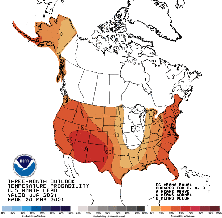
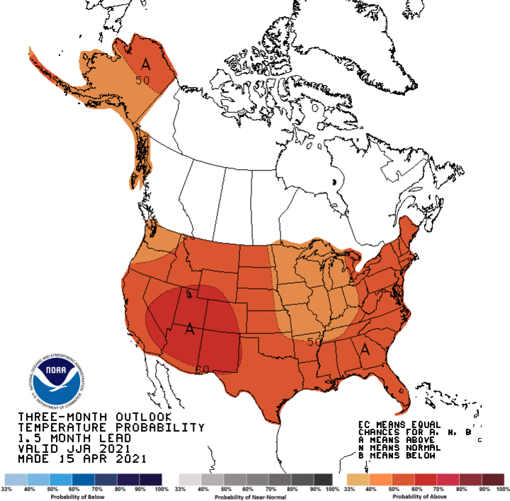
The Climate Prediction Center released its summer forecast yesterday morning, along with its moving three-month forecasts. Figure 1 depicts CPC’s official summer temperature outlook and Figure 2 represents their 1.5 month lead time summer temperature outlook issued April 18. The net change between the two figures is a decrease in the probabilities for above normal temperatures for the central United States. Although above normal summer temperatures are predicted for Nebraska, the odds have decreased an average of 5 percentile points from last month’s release.
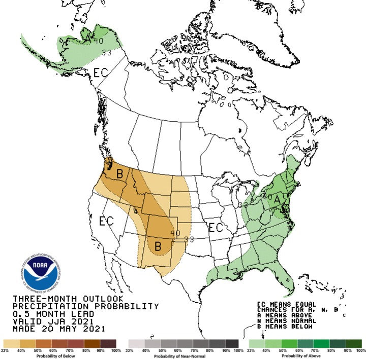
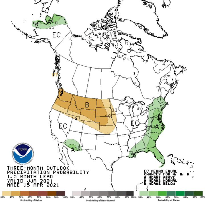
There has been a fairly substantial shift in the predicted areas of below normal moisture from yesterday’s official summer precipitation outlook compared to the 1.5 month lead forecast issued last month. Figure 3 represents the official CPC summer precipitation outlook and Figure 4 is the summer outlook issued last month for visual comparison. There has been a weakening of below normal precipitation odds by 5-10 percentile points for the northern and central Plains. CPC also shifted the highest probability levels from the northern Rockies and northern half of the High Plains to the spine to the entire Rocky Mountain region and the Pacific Northwest.


As I have stated in previous monthly and seasonal updates, I believe CPC has overplayed the dryness forecasts for the central United States and that moisture improvement across the northern Plains were likely once the mechanisms were in place to transport atmospheric moisture northward from the Gulf of Mexico. This moisture flow should be above normal due to the past week of heavy precipitation from Kansas southward, along with distinct periods of storm activity that began in December.
The past week has brought copious moisture to the southern half of the High Plains, as well as Missouri, Arkansas and Louisiana to the east and eastern Colorado to the west. Some of this heavy moisture hit parts of southwest Nebraska this week with 2-4 inches of rainfall. If weather models are correct, this trend will shift into the northern Plains (Montana, North Dakota, South Dakota) over the next two weeks due to a blocking high pressure system that has developed over the southeastern U.S. It is this blocking high that is the key forecast metric I am concentrating on regarding weather conditions for Nebraska during the first half of the summer.
Ever since La Nina condition in the Equatorial Pacific peaked in mid-December, upper air lows have been coming into the Pacific Northwest via two modes of action. When the eastern U.S. upper air trough was strong (like February and this past month (early April-early May), pieces of energy were breaking off and drifting south-southwest into the central/southern Rockies. High pressure in the eastern Gulf of Alaska was strong enough, that energy from the western Gulf of Alaska was able to undercut the high pressure and move energy into the Pacific Northwest. When the eastern U.S. upper air trough was weak, energy from the eastern Gulf of Alaska upper air low dove southeast into the southern Great Basin, then slowly progressed east through the southern half of the High Plains region.
Since we have seen the eastern U.S. trough dominate the last four weeks, we are due to see a pattern shift favoring a weaker eastern trough and more energy moving into the eastern Gulf of Alaska. When the eastern U.S. upper air trough is weak, the Bermuda high builds westward into the southeastern U.S. So if hemispheric pattern shifts adhere to climatological principles, we should see fewer instances of the eastern U.S. trough building southward past the lower Ohio river valley during June.
As upper air lows move into the Pacific Northwest, southerly flow from the southern Plains will increase moisture advection northward from the Gulf of Mexico and from transpiring crops that have ample soil moisture from past and recent precipitation events. This set up would increase the likelihood for some relief across the northern Plains, but you do not eliminate extreme drought conditions overnight. It will likely require above normal moisture through the entire summer and fall to completely eradicate it, just like Nebraska experienced in 2013 following the epic 2012 drought.
With La Nina over and above normal sea surface temperature anomalies spreading across the eastern Equatorial Pacific, there should be a much better monsoon season and normal to above normal tropical activity. This is especially important during the late summer through early fall period for tropical systems moving northward along the northwest Mexico coastline (Baja runners) that bring moisture into the southwestern U.S.
Last year was a bust for monsoon moisture as usually is the case during La Nina events. Couple this with mountain snowpack values within normal range for this time of the year east of the Continental Divide (central/northern Rockies) and we should see a much shorter timeframe between snow melt out and the beginning of the monsoon season. We are already seeing front range storm development and I see that continuing through June (central Rockies) and July (northern Rockies).
So in short, I do not agree with CPC's depiction of temperatures which indicate a mean trough position over the Central Corn Belt (Iowa, Illinois). I certainly do not agree with below normal moisture through the entire Rocky Mountain region. I could see dryness across the northern Great Basin west of the Continental Divide. The southern Great Basin summer precipitation will boil down to the monsoon season. Right now I would place my odds toward normal moisture. I am also favoring dryness across the southeastern U.S., especially the first half of the summer.
With all of the moisture that has fallen across the southern Plains recently, it will be transpired into the atmosphere, so relative humidity levels will be high through the entirety of the High Plains the first half of the summer. The only thing needed is a trigger to initiate thunderstorm activity. That should be available if the current long wave pattern favoring western United States storm activity continues. Additionally, since there has been a strong tendency for western trough activity to slowly migrate east (if not cutoff). When this happens, precipitation events may happen over multiple days, instead of in a single day timeframe. Thus, under high atmospheric moisture, this type of pattern can dump a month's worth of precipitation over a couple of days.
The second half of the summer precipitation pattern for the northern half of the High Plains will be determined by whether the southeast U.S. upper air high can build northward into the Eastern Corn Belt or whether the eastern U.S. upper can deepen south of the Ohio River valley. If the southeastern U.S. high pressure expands northward and drought conditions develop, the Western Corn Belt would continue to be favored for above normal moisture due to return flow on the backside of this high pressure system, as well as being on the front side of troughs ejecting out of the western U.S.
If the eastern U.S. strengthens, then the Western Corn Belt will be on the western flank of the trough and northwest flow aloft will be dominate. With upper air flow pushing southeastward across the Dakota’s, it is important that the current opportunities for moisture come to fruition. Otherwise, surface fronts will have little atmospheric moisture available to precipitate out as fronts push southeast. Below normal moisture and above normal temperatures would expand southeastward from the northern High Plains during the second half of July through most of August.
