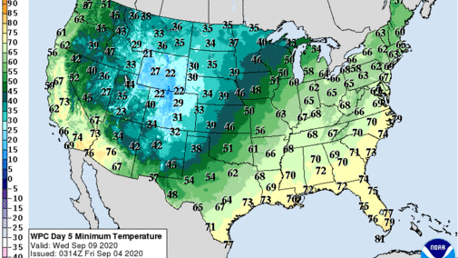
The latest GFS model run from this morning (September 4) indicates that the cold air event projected by NOAA will likely bring frost/freeze conditions to the upper Midwest. A powerful upper air trough will deepen over the nation’s midsection September 8-9, bringing cold, rainy conditions to the northern and central Plains.
The front is projected to begin its move through the state September 8 and produce widespread cold rains and strong winds statewide, with snow or a mix of snow and rain across the Nebraska Panhandle. High temperatures may struggle to get out of the 50’s September 8. Further north, the northern 1/3-1/2 of North Dakota and Minnesota should be cold enough to see frost/freeze conditions.
The key issue in regards to frost potential across the state will be the extent of cloud cover, the amount of soil heat that could inhibit frost formation, and whether snowfall will accumulate across the Panhandle that could help reinforce the cold air sliding southward out of Canada. Currently, the GFS model brings the 540 thickness line (associated with surface freezing) into the northern half of the Panhandle of the state from the evening hours of September 8 through 8 am September 9. Wednesday morning (September 2) the GFS model had the entirety of the eastern half of the state under the 540 thickness line, so there has been considerable movement of the core area of cold almost 200 miles west of Wednesdays forecast.
With the surface heat in place prior to this cold air blast, low temperatures will likely visit the lower 30’s across the Panhandle, with hard freeze conditions (
With wheat planting right around the corner, this system has the potential for 1-2 inches of moisture across the eastern half of the state and 0.50-1.00 inch totals for the western half of the state. This system is projected to form a semi cutoff low over southern Kansas on September 9 then slowly drift northward into the western Great Lakes by September 11.
There is considerable uncertainty with GFS with this upper air trough and latest model trends have sped up its movement, which would bring a return to normal to above normal temperatures and below normal moisture from next weekend through September 18th, possibly longer as this is at the end of the model’s forecast period. If this system slows down, a return to above normal temperatures will be delayed by 2-3 days. However, the delay would mean that as the upper air low passes just to the east of the state, wrap around moisture would produce a widespread rain event for the eastern half of the state.
The latest GFS model run from mid-day September 2 indicates that the cold air event projected by NOAA will likely bring frost/freeze conditions to the upper Midwest. A powerful upper air trough will deepen over the nation’s midsection September 7-8, bringing cold, rainy conditions to the northern Plains. The front is projected to sweep through the state on September 8 and produce widespread cold rains and strong winds. High temperatures may struggle to get out of the 50’s September 8. Further north, North Dakota and Minnesota should be cold enough to see snow accumulations and the potential is there for accumulations greater than 3 inches.The key issue in regards to frost potential across the state will be the extent of cloud cover, the amount of soil heat that could inhibit frost formation, and whether significant snowfall will occur north of the state that could help reinforce the cold air sliding southward out of Canada. Currently, the GFS model brings the 540 thickness line (associated with surface freezing) across the eastern half of the state from midnight September 8 through 8 am September 9. Usually early forecasted freeze events require a 534 thickness line to bring widespread frost to near hard freeze conditions to a region.
With the surface heat in place prior to this cold air blast, low temperatures will likely visit the 30’s with scattered frost in the usual cold air drainage locations across the northern two thirds of the state. Today’s model runs are the first to bring the 540 line southward into the eastern half of the state. For the majority of the last 10 days, the GFS model has pulled the brunt of the cold into Minnesota, Wisconsin, and Michigan. Since this event is still several days into the future, expect to see frost/freeze conditions shifted throughout the upper Midwest. What is certain and has been in the models for the past 10 days is that the coldest air of the second half of 2020 will arrive next week and frost/freeze conditions are likely across the northern tier of the country. How far southward Jack Frost strays, remains to be seen.
-->
