There is no doubt that it has been a challenging planting season for Nebraska producers. However, corn planting here is substantially ahead of the eastern Corn Belt. As of May 13, the National Agricultural Statistics Service reported Nebraska corn planting 46% complete, compared to Iowa, 48%; Kansas, 46%; and Missouri, 52%.
3 Ag Impacts
from Early-Season Weather
- Continued corn planting delays or "mudding in" of crops is likely in the central, northern, and eastern Corn Belt due to excessive moisture. If rains continue and then there's a sudden shift to dry conditions, shallow root syndrome could become an issue. (This can occur when there is so much moisture early season that roots don't grow deep enough to access deeper water when the top soil layers dry out later in the season.)
- Humidity levels are going to be high the first half of the summer, no matter what, due to full soil profiles across the Corn Belt and the transpiration of that moisture by crops into the lower atmosphere. Also contributing will be mid- and upper-level moisture from the abundant snowpack in the southern Rockies and increased Pacific moisture evaporation due to above-normal sea surface temperatures in the Equatorial Pacific. Therefore, cattle stress could be problematic if there are low winds and above normal temperatures. In addition, crop diseases prone to high relative humidity environments may be an issue this summer.
- Late planting will place the crop at a greater risk of reaching pollination during the statistically hottest time of the year. Many recent crops have had slow starts in cool conditions, but made up for it with above-normal temperatures from mid-August through early October. With a 60% or greater chance that El Nino conditions would prevail by late August, a return to wet/cool conditions would increase the risk of frost prior to crop maturity, especially in the northern Corn Belt, plus it could set up producers for wet conditions and a slow harvest like last year.
The eastern and northern Corn Belt are significantly behind normal. Illinois reported 11% planted, a full 71% behind normal. Other important corn producing states reported similar trends: South Dakota (4% complete, 51% behind normal), North Dakota (11%, 32%), Minnesota (2%, 44%), Wisconsin (14%, 32%), Indiana (6%, 51%), Ohio (4%, 43%), and Michigan (5%, 29%). Nebraska at 26% behind normal and Iowa at 28% behind were the most advanced within the primary Corn Belt.
Hopefully, the past few days of very warm temperatures and widely scattered convection have allowed producers across the state to plant enough corn to push next week’s NASS corn planting numbers above 75%. Unfortunately, it appears that a series of weather systems will impact much of the Corn Belt with moderate to heavy rainfall. If the forecast comes to fruition, significant planting delays will continue or farmers will mud in their crop.
A strong upper air trough to our west in combination with a weaker northern jet will serve as the focal point for widespread rainfall May 17-19 across the central Corn Belt. The first system begins to move out of the Rockies on May 17 and will interact with the northern jet lying across the Dakotas. Rain is likely across South Dakota and northern Nebraska May 17, with additional rainfall May 18 across northern Nebraska. Localized heavy rain and severe weather are possible. Southern Nebraska is expected to see more widely scattered precipitation.
From May 19-22, several pieces of energy will eject out of the western U.S. trough before the primary low swings through the region on May 22. Expect several rounds of thunderstorms under mostly cloudy conditions. Some sunshine will appear, but cloudiness will dominate. This will lead to cooler temperatures (upper 50s in the north to mid-60s in the south) and the potential for 1-3 inches of rainfall across the eastern three-quarters of the state.
This strong system will push to our east next week and bring widespread rainfall to Wisconsin, Illinois, Iowa, Indiana, and Michigan.
The forecast for May 23-27 includes drier and warmer conditions, with a potential for widely scattered thunderstorms. The Panhandle and the northeastern corner of the state are the most likely areas for scattered showers/thunderstorms May 23-24. Isolated to scattered thunderstorms are possible across extreme eastern/southeastern Nebraska May 26-27.
Unfortunately, it appears another upper air trough will build over the western U.S. in late May with models hinting at widespread heavy rainfall and severe weather May 28-31, before the system moves east to saturate the eastern Corn Belt.
Summer Outlook
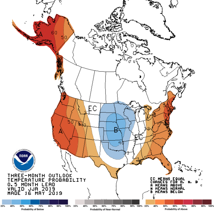
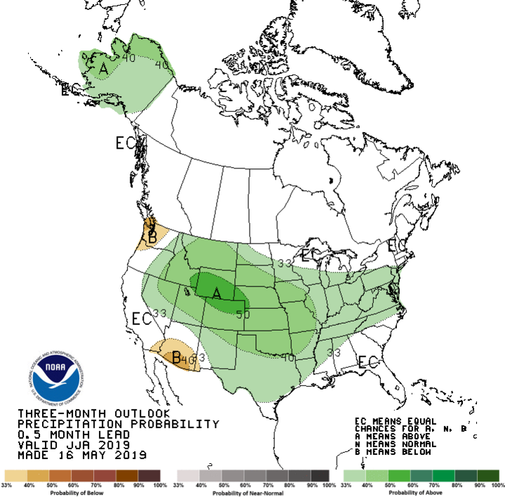
The Climate Prediction Center (CPC) is showing most of the High Plains and central Corn Belt region with a tendency toward below-normal precipitation in the 90-day forecast, with both the eastern and western third of the country tilted toward above-normal temperatures. The central and northern Rockies are once again looking at above-normal precipitation, particularly for areas east of the Rockies and outside the Great Lakes region.
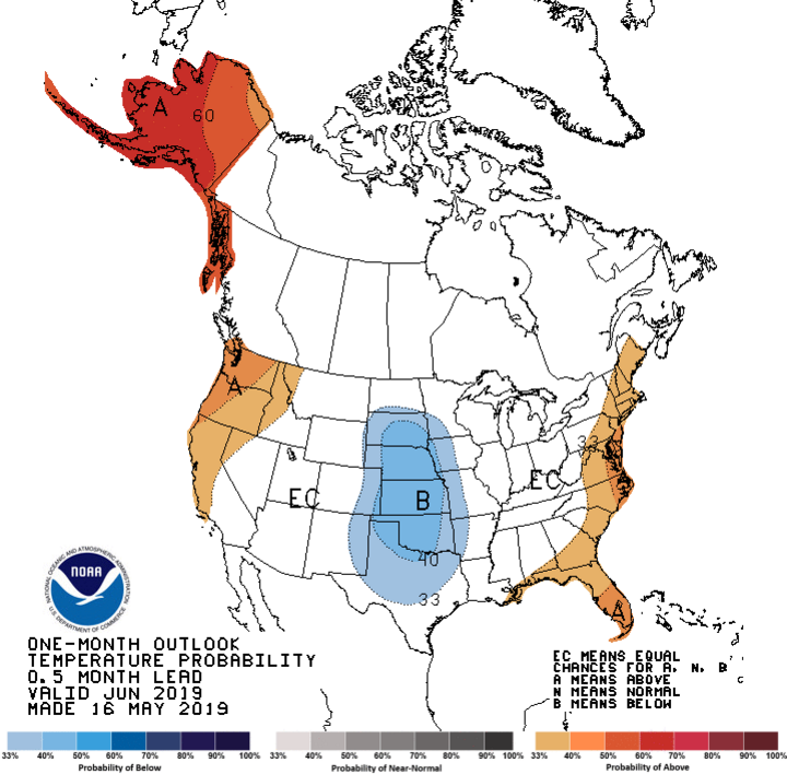
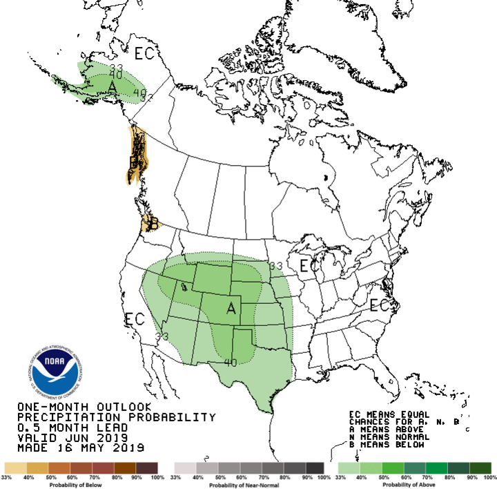
A strong cold signal shows up in the 30-day forecast from the South Dakota-North Dakota border south to central Texas. Slivers of above-normal temperatures are indicated for the west and east coasts, with equal chances of above-normal, normal, and below-normal moisture elsewhere. Above-normal moisture projections include the central and southern Rockies, as well as the High Plains region from South Dakota through southern Texas.
Once again, the CPC has an aggressive precipitation pattern in the 30- and 90-day forecasts. The current wet pattern appears to hold through early June.


Factors increasing the odds of above-normal moisture during June include abundant moisture from a tremendous snow pack across the southern Rockies and a continuing weak El Nino through the summer. States east of the High Plains (Iowa, Missouri, Illinois, Wisconsin, southern Minnesota, and southern Michigan) will likely share in above-normal moisture.
Temperatures in the 30-day forecast will likely be driven by the extent of cloudiness.
Forecasting precipitation for the entire summer is difficult at best, so I am going to use climatology as a basis for my 90-day forecast. The abundance of moisture across the southern Rockies should translate to increased Front Range convection in June through early July, strongly favoring the western third of Texas, Oklahoma, Kansas, and Nebraska. If a weak trough continues across the western U.S. through June, these convection events will likely move into the central and eastern portions of these states and increase the odds of above-normal moisture.
Further east, the northern jet’s position will determine where the front side of the western U.S. upper air trough intersects the weaker northern stream over the upper Midwest. If the trough remains positioned as it is currently, many of the areas currently experiencing weather delays, will likely continue to through June.
After June, there is considerable uncertainty in the forecast, as the western U.S. trough generally weakens during the summer with less energy translating northeastward into the upper Midwest. The CPC has now increased its forecast for El Nino conditions to continue for the entire summer, with a 60% chance of El Nino continuing through fall. I will be paying attention to whether we see drier and warmer conditions for the central/eastern Corn Belt begin to develop during July and August (typical El Nino climate conditions, but not a guarantee).
If typical El Nino summer conditions occur, the above-normal snowpack across the southern half of the Rockies should allow for convection development along the Front Range. This should help offset the tendency toward below-normal moisture that is more common east of the central and southern High Plains region during the second half of the summer. This would increase the odds of thunderstorm activity during the critical grain-fill period (soybeans, corn, sorghum) in the High Plains region, Nebraska and southward.

