After another week of heavy precipitation across a substantial portion of the Corn Belt, planting delay and replant issues continue to plague producers, especially across the eastern Corn Belt. There are signs, however, that a considerably drier forecast may be unfolding as the calendar turns to June.
Amid widespread rain, corn planting in Illinois, Indiana, Michigan, and Ohio progressed little and ranged from 22%-33% complete as of May 26.
Nebraska wasn’t immune to the heavy moisture this past week. Widespread rain of 3-6 inches was reported across the state. Fortunately for Nebraska, corn planting was virtually complete as of Sunday outside of the northern 25% of the state. Soybean planting was still behind normal with 56% of the crop planted here in Nebraska, the highest percentage of any Corn Belt state.
As bad as planting progress has been, a drier forecast for June offers welcome relief. First, the blocking southeastern U.S. upper air ridge that has brought record warmth and dry conditions to the southeast is projected to weaken dramatically over the next 10 days. This will help break the persistent upper air trough centered over the western U.S. that has fed the endless string of stormy weather for much of the Corn Belt.
The system that impacted Nebraska over the Memorial Day weekend is now progressing to the upper Mississippi River valley. In its wake, high pressure will move into the western Corn Belt and bring sun and warmth to the region. Unfortunately, continued periods of rainfall will persist across the eastern Corn Belt. More importantly, this system is projected to deepen east of us and begin to break down the upper air ridge in the southeastern U.S.
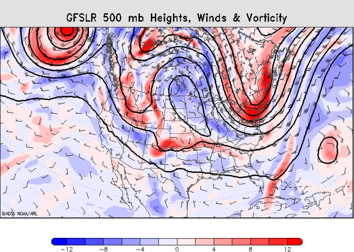
As the ridge in the southeast breaks down, an upper air ridge is projected to develop across the northern Plains and south central Canada by mid-June (Figure 1). Much drier conditions are likely to develop across the Dakotas, Nebraska, Minnesota, and Wisconsin. Cooler than normal temperatures will be most favored for the eastern Corn Belt.
However, energy is still expected to move under this ridge and cut through the central Plains (Oklahoma, Kansas, and southern Nebraska). As this energy moves eastward, it is projected to weaken and be absorbed by the upper air trough expected to develop during the next week. Therefore, drier conditions are likely across the eastern Corn Belt. If the extended forecast holds, expect that the planting pace will pick up, but be limited by the extensive flooding there.
Short-Term Forecast for Nebraska
The latest model runs as of May 29 hint at drier weather for Nebraska over the next two weeks, but several precipitation opportunities exist. The first system will move through the eastern half of Nebraska from the overnight hours Friday through the first half of Saturday. Currently, less than 0.25 inch of rain is forecast, heaviest across the northeastern quarter of the state.
Another piece of energy moving into the central Plains on Monday will increase thunderstorm chances across the western third of the state. This energy is forecasted to move into central and eastern Nebraska on Tuesday, possibly holding on through Wednesday morning. East central and southeast Nebraska could receive 0.50 to 1.50 inches, with the extreme southeastern corner of the state projected to receive the heaviest moisture.
The next system is expected to impact extreme southern Nebraska on Thursday, but the majority of moisture is expected to hit Kansas. Current model projections suggest the southern tier of counties will get 0.25 inch or less of moisture.
The next system, forecast for June 12, will primarily impact the Panhandle as high pressure over the western Corn Belt shifts eastward and creates upslope flow conditions as winds at the surface take on a southeasterly component as the upper air high shifts eastward. As this ridge shifts eastward, dry conditions develop across the northern and eastern Corn Belt.
Normal to above normal temperatures are likely over the next two weeks for the western Corn Belt. However, drier conditions with cooler temperatures are projected to develop across the eastern Corn Belt by the end of next weekend, with no precipitation forecasted for the following week.
