The Goshen Irrigation District (GID) and the Gering-Fort Laramie Irrigation District (GFD) on Thursday jointly announced a plan for permanent repairs to Tunnel 2. The collapse of Tunnel 2, in the Wyoming portion of the canal, in late July halted irrigation water delivery to more than 100,000 acres in eastern Wyoming and western Nebraska.
Get a bird's-eye view of the sites discussed in the story by placing the following longitudes and latitudes into Google Earth:
Whalen Dam Diversion: 42.247947°, -104.629175°
Goshen / Gering-Ft Laramie Canal Headwaters: 42.247599°, -104.629632°
Pathfinder Canal Headwaters: 42.247926°, -104.628554°
Tunnel 1
Entrance: 42.220984°, -104.565794°
Exit: 42.213569°, -104.565990°
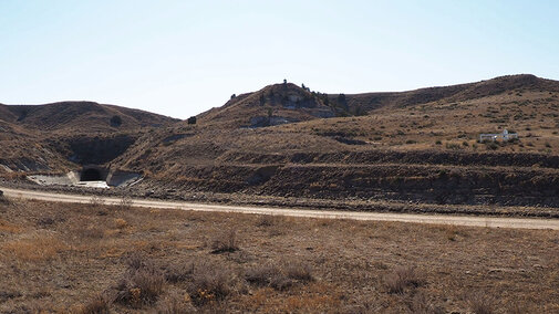
Tunnel 2
Entrance: 42.188976°, -104.500286°
Exit: 42.183287°, -104.498447°
Tunnel 3
Entrance: 41.832989°, -103.793531°
Exit: 41.817961°, -103.780679°
This is one of three tunnels on the main irrigation canal which begins at the Whalen Diversion Dam near Guernsey, Wyo., where water is diverted from the North Platte River to run 129 miles through Goshen County, Wyo., and Scotts Bluff County, Nebr. The canal delivers water to about 107,000 acres of cropland in the two irrigation districts. Collapse of Tunnel 2 disrupted water delivery for about six weeks in July, August, and September 2019 until temporary repairs could be made.
An update from the Goshen Irrigation District on Thursday described plans for permanent repairs.
“I commend both district boards for the leadership they demonstrated to make a tough decision that ultimately affects this entire valley and its agricultural economy,” said Rob Posten, manager of the Goshen Irrigation District.
The plan includes interim repair work to stabilize the tunnel with additional ribbing supports and void grouting for the 2020 water season. The plan also includes initiating a chemical grouting process that will stabilize and harden the outside of the tunnel permanently. The irrigation boards considered more than 10 options after consulting with the United States Bureau of Reclamation. Both irrigation districts gathered cost estimates and researched the grouting technology.
"The permanent grouting option builds upon the temporary repair efforts done in 2019 and is expected to stabilize and secure the tunnel structure in the long term," notes the release. "The same grouting process will also be used to stabilize, repair and secure Tunnel 1, which after the collapse, was identified for additional repairs and long-term stabilization for the tunnel’s structural integrity."
Interim tunnel work has commenced and will continue in the upcoming weeks. The initiation of the planning, engineering and environmental permitting for the permanent fix will begin shortly.
Among the many structural considerations, the boards also considered the nearby historical artifacts of the Oregon Trail (see Oregon Trail).
Tunnels 1 and 2 are located in Goshen County, Wyo. Tunnel 1 is located near historical Fort Laramie, the Oregon Trail, and a pioneer gravesite. Tunnel 1 is approximately 0.52 miles long and is in the Arikaree (geologic) Formation, which consists mainly of gray, fine, loose-to-compact sand with layers of hard, fine-grained, dark-gray concretions which vary from a few inches to 15 inches and often have tabular form. It also includes a large amount of volcanic ash mixed in with the sand.
Tunnel 2, which collapsed in July, is approximately 0.40 miles long and also in the Arikaree Formation.This tunnel also has nearby historical artifacts.
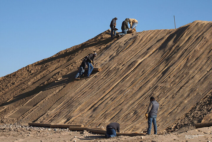
SAK, the contractor for the temporary repairs to Tunnel 2, will be removing the trench boxes to facilitate repairs to the main tunnel collapse site. Working from the outlet end of Tunnel 2, the contractors will be installing more “ribs” inside the tunnel per U.S. Bureau of Reclamation recommendations. GID and GFD personnel are installing fabric mats (Figure 2) to stabilize the excavated soil from the collapse site to prevent wind erosion and sloughing. Work on the site of the actual canal breach has been completed.
Tunnel 3 is located near Rifle Sight Pass in Scotts Bluff County, Nebr. The tunnel is approximately 1.23 miles long and is in the Brule Formation, which consists mainly of a hard, sandy clay of pale-pink color. Due to the length of the tunnel and its location in the Brule Formation, pumping the special cement into the void may be the only upgrade option.
All three tunnels will have to have an Environmental Assessment (EA) and other permitting processes completed prior to any work being started. Funding for the repair/upgrade of the tunnels is still in question. The start and completion dates for the repairs/upgrades will depend on how fast the permitting process is completed and the source of funding.
The Fort Laramie National Historic Site is approximately 51 miles west of Scotts Bluff National Monument and 71 miles west of Chimney Rock National Historic Site, all along the North Platte River Valley.
Visible Remnants of the Oregon Trail
To view these historical sites, place the following longitudes and latitudes into Google Earth:
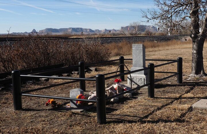
- Homsley Grave Marker on Oregon Trail
42.222104°, -104.566372° - Oregon Trail Ruts
42.221834°, -104.574312° - Old Fort Laramie National Historical Site
42.202762°, -104.557474° - Scotts Bluff National Monument
41.836970°, -103.700470° - Chimney Rock National Historical Site
41.703850°, -103.347971°
Nearby Oregon Trail Artifacts
Historical artifacts of the great migration along the Oregon Trail (Oregon-California Trail) today affect decision-making for land use along its path.
The Oregon Trail started in Independence, Mo., and then later in Council Bluffs, Iowa, and ends near Oregon City, Ore. It is approximately 2,000 miles long and crosses six states: Missouri, Kansas, Nebraska, Wyoming, Idaho, and Oregon. The Mormon Trail, which starts in Nauvoo, Ill., follows the same basic route, most of which was on the north side of the Platte River Valley, until the trails merged near Casper, Wyo. The Mormon Trail diverges from the Oregon Trail at Fort Bridger, Wyo. The routes basically “followed the water” across the “Great American Desert.” For the Oregon Trail this included the Kansas, Little Blue, Platte, North Platte, Sweetwater, Green, Snake, Columbia and other rivers.
The largest numbers of pioneers, estimated to be over 400,000, crossed the “Great American Desert” from the 1840s through the 1860s. Some of the key points along the trails in Nebraska are Fort Kearney, Ash Hollow, Chimney Rock, and Scotts Bluff. Key points in Wyoming are Fort Laramie, Register Cliff, Independence Rock, Devils Gate, and South Pass. South Pass is where the trail crosses the Continental Divide and is located in the high prairie, not the mountains.
Many hardships followed the pioneers across the trails, overturned wagons, sickness, bad weather, death. Some were buried in the trail to hide the grave so that it would not be disturbed by humans or animals. Others were marked at the time and some of those remain today. The grave of Rebecca Winters is just east of Scottsbluff along Highway 26. Other graves, such as that of Mary Homsley, are out on the open prairie along the Oregon Trail. Such sites are our history and legacy.
More Information
- Nebraska Extension and the University of Wyoming Extension are working together and hosting a joint website to share information about this situation.
- For information on the North Platte River and the irrigation projects in Nebraska and Wyoming, visit the slideshare presentation on the University of Nebraska Panhandle Research and Extension Center website.
- See related CropWatch stories on the canal tunnel collapse and repair.
