With all the planting delays across the Corn Belt due to excessive moisture during the planting season, producers may want to consider paying close attention to disease issues that develop under high relative humidity levels.
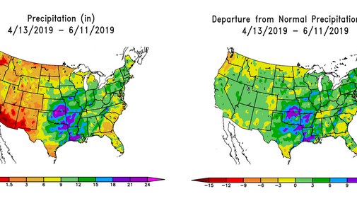
This will be particularly important in flood-ravaged areas south of Nebraska, including southern Kansas, northern Oklahoma, southern Missouri, and northern Arkansas. Figure 1 depicts the accumulated precipitation during the past 60 days, as well as the departure from normal for the same period. (View larger versions of Figures 1a and 1b.) You will notice that there is a large area south of Nebraska with 9-15 inch surpluses. Soils are saturated, especially for areas feeding the Arkansas River basin. Any significant surface wind from this area will bring this low level moisture northward.
In addition, snowpack in the central and southern Rockies is abnormally large for this time of the year. The Natural Resource and Conservation Service (NRCS) snow course data from June 12, 2019 indicates that the Colorado River basin has a current snow-water content estimated at 845% percent of normal due to a very cold May and a subsequent slow melt season.
Over the past week, streamflow rates into Lake Powel have doubled from just shy of 35,000 cubic feet per second to just shy of 75,000 cubic feet per second as of June 11, 2019. If snowmelt continues at the current pace, it will be at least two more weeks before much of the southern Rockies snowpack in the highest elevations is melted out.

These two areas should provide above normal low level moisture transport north (Oklahoma/Kansas) and mid to upper level moisture over the central/southern Rockies for transport east/northeast if another upper level trough builds into the western U.S. Unfortunately, the latest GFS model runs indicate an above-average potential for another trough to build across the western U.S. as the ridge across the southeastern U.S. redevelops (Figure 2).
In addition, drought across south central Canada has built southward to include the northern third of North Dakota. This area has been building slowly south-southwestward toward northern Montana and Idaho. If this pattern continues, along with a building dome of high pressure over the southeastern U.S., upper air troughs moving across the southern Rockies will have additional moisture to extract from the atmosphere.
A moisture channel would likely form between the high pressure systems over the southeastern U.S. and the northern Plains. This would increase the odds that above normal moisture would be directed toward the Corn Belt, increasing the odds that heavy moisture would develop. At this time, the GFS indicates that the much of the area along and south of the I-80 corridor from eastern Nebraska through Ohio would be vulnerable to periodic heavy rainfall.
If the trough develops across the western U.S. the third full week of June as predicted, temperatures will rebound to normal to above normal temperatures next week, with above normal temperatures favored for the last full week of June. This should promote rapid growth for the state’s corn crop, but will also mean that evapotranspiration rates will be increasing, which adds more low level moisture into the atmosphere, which would increase relative humidity levels even without a frontal boundary to trigger precipitation.
Finally, El Nino conditions continue and are expected to continue through this fall, so surface evaporation from the central Pacific Ocean should be drawn northeastward to the southwestern U.S. anytime a trough develops in the Gulf of Alaska and heads southeastward towards the western U.S. Therefore, any upper air troughs that make it into the central/southern Rockies will have an additional moisture source available, only increasing the potential for high relative humidity values being drawn northward from the southern Plains when surface lows develop in advance of the approaching upper air troughs as they head eastward out of the southern/central Rocky Mountains.
