Impacts continue from the Bomb Cyclone event in mid-March and the subsequent blizzard that hit the Upper Plains last week. Although a substantial portion of southern Nebraska missed out on the heavier precipitation, even small precipitation events are requiring several days of drying before field work can occur. For northern Nebraska, recent precipitation resulted in renewed standing water, making fertilizer application difficult.

Soil Temperatures
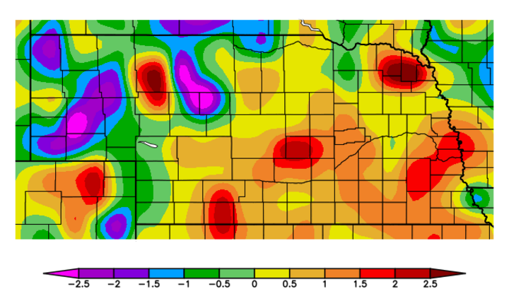
From a temperature standpoint, the most recent 30 days have actually been beneficial. Figure 1 shows temperature departures from normal across the state with the prevailing trend being slightly warmer than normal. The only areas of the state depicting below normal temperatures are those hit with the worst of last week’s snow. Across the eastern two-thirds of the state, above normal daily temperatures are outpacing below normal temperatures by two to one.
Soil temperatures have been constrained by wet surface (top foot) and sub-surface (1-5 feet) conditions. It takes considerably more energy to get wet soils versus dry soils to warm; however, when they do warm up, wet soils hold on to the heat longer. This means that daily soil temperature extremes are less extreme with wetter soils.
Current average daily soil temperatures are moving into the upper 40s to low 50s across southern Nebraska, with upper 30s to low 40s common across the northern half of the state. With several days of 70 plus weather last week and at the beginning of this week, bare soil 4-inch temperatures spiked into the mid to upper 60s during the mid to late afternoon across the southern two-thirds of the state.
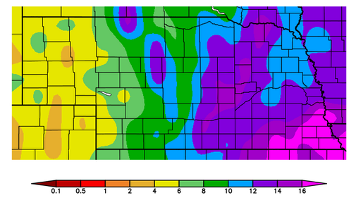
How quickly soils warm below 4 inches remains to be seen. Certainly for areas east of the Panhandle, the soil moisture recharge period (October to present) has been generous. In fact, looking at Figure 2, it is apparent that the eastern third of the state received between 10 and 16 inches of moisture over this period. (Note that this doesn’t even include the widespread 2-8 inch totals received in September.)
Soil Moisture
Soil moisture is at field capacity down to at least 4 feet east of the Panhandle and the native vegetation response to the last 30 days of above normal temperatures has been slow. Since this vegetation has a large percentage of its root structure below 4 inches, cooler soil temperatures are likely slowing its break from full dormancy as compared to drier soil conditions under the same temperature regime.
Once our native vegetation (trees) canopies out and grasslands begin to actively grow, it should translate into drier surface conditions through transpiration. Of course, if rainfall rates exceed soil moisture extraction, surfaces will continue to remain on the wetter side.
Silver Linings
There are two positives to take away from an otherwise trying spring season. First, we have a substantial reserve of soil moisture, so an ample resource of moisture exists if we get into a short-term (less than three-week) dry pattern during the first half of the growing season.
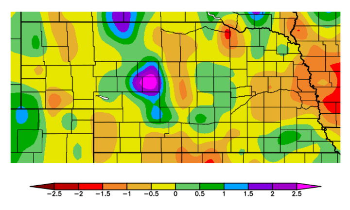
Second, although rains keep rewetting surfaces and making planting season a challenge, most of Nebraska has actually experienced below-normal moisture the last 30 days (Figure 3). If this trend continues for the next 30 days, planting delays will likely become a distant memory except for those areas still dealing with significant storm damage from the mid-March storm.
Late April Forecast
At least in the short term, there appear to be planting opportunities for those areas that escaped the wetter portion of recent storms. Looking into the short-term future, numerical models point to two primary precipitation periods through the end of April. The first is this weekend with a strong trough moving eastward from the Central Rockies.
Moisture should develop late Sunday through early Monday then shift east-southeast through the day. According to the Quantitative Precipitation Forecast, this weekend’s event may bring 0.25-0.75 inch of precipitation to the western Panhandle and 0.10-0.50 inch to the eastern half of the Panhandle. The southern third of Nebraska is projected to get 0.10-0.50 inch of precipitation, with the heaviest moisture projected to fall along the Kansas-Nebraska border from McCook to Red Cloud. The northern third of the state east of the Panhandle is forecasted to receive less than a 0.20 inch of moisture.
After a dry stretch from April 21-26, models indicate that a strong system will cross the Central Rockies and lead to widespread rainfall sometime within the April 27-30 timeframe due to model uncertainty about the timing of the trough moving into the central Plains. Although this event is well over a week away, models the last five days have indicated some localized heavy rain and severe weather developing over the Central Plains. Currently the eastern half of the state appears to have the highest probability of receiving significant moisture.
