Even with September temperatures well above normal for most of the Corn Belt, this year’s national soybean and corn crops continue to lag in development compared to the five-year average. Nationally, 58% of the corn crop had reached black layer as of October 4, according to the National Agricultural Statistics Service, compared to the five-year average of 75%. Soybeans turning color nationally stood at 72%, compared to the five-year average of 90%.
For Nebraska, NASS reports that 74% of the corn crop had reached black layer, compared to the five-year average of 95% by October 4. Corn acres harvested stood at 14%, compared to the five-year average of 30%. Soybeans had or were turning color on 86% of the acreage planted, compared to the five year average of 90%. Soybeans harvested stood at 14%, compared to the five-year average of 31%.
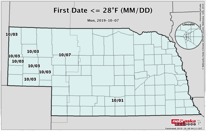
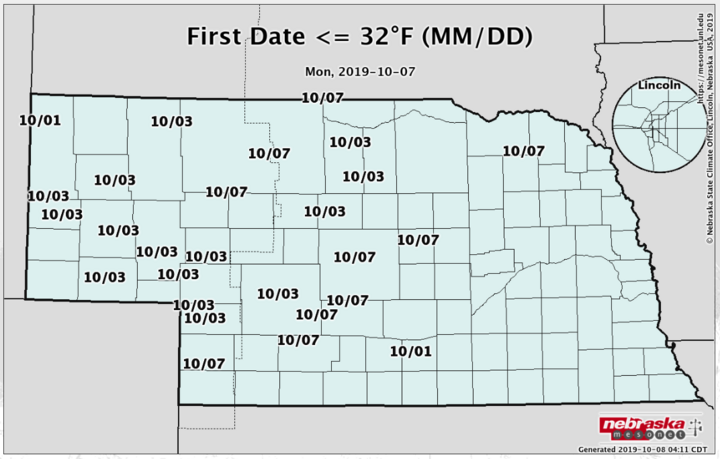
Hard freeze conditions (minimum temperature of 28°F or lower) were met at Nebraska State Climate Office Mesonet locations in the Panhandle on October 3. Frost conditions (minimum temperature above 28°F to 32°F) were met at other sites from central to western Nebraska October 1-7. If the significant storm system projected to impact the northern Plains and upper Midwest materializes as currently projected, hard freeze conditions will likely be met for all areas north of I-80 by the end of this weekend.
With so much late summer and early fall wetness across the region, every precipitation event going forward has the potential to bring harvest activity to a grinding halt. The big question is how extensive will the delays be. On this front, I have good news and bad news.
First, the bad news. A potent upper air trough will eject out of the northern half of the Rockies during the middle of this week, then slowly move toward the upper Great Lakes by the end of this weekend. This system is forecasted to deepen and bring widespread snowfall to the Dakotas and Minnesota Thursday through Friday. At present, the northern one-fourth of the state sits at the southern periphery of this potential snowstorm.
If this system dives a little deeper southward, snowfall accumulations of over 6 inches would be possible across the northern third of the Panhandle eastward through Cherry County. The area immediately east of this region would have the best odds for accumulating snowfall on Friday. The potential limitation on snowfall accumulations will be how rapidly rain changes to snow and how quickly snowfall can accumulate on soils with temperatures currently in the 40s and 50s.


The Nebraska State Climate Office is tracking the first 32°F and 28°F freeze events of the fall. Go to mesonet.unl.edu and click on the “Daily Maps.” Then use the pull-down menu to the left of the displayed map to select for the first 32°F or 28°F of the year reported at each location (date given on the map).
This system will contain sustained winds over 30 mph across the Dakotas and Minnesota, with gust likely to exceed 50 mph. To the south across Nebraska, winds will likely be in the 20-30 mph range, which has the potential to create lodging problems in corn fields with known stalk rot issues. More importantly, if the rain changes to snow, expect very heavy-laden snow that will cling to everything it touches. Soybeans and corn face the potential for snow loading and some flattened corn and soybean fields.
If we can escape this system’s snow impacts, harvest weather going forward looks much more promising than the past couple weeks. After the upper air low associated with this week’s projected snowstorm moves into the Great Lakes region, high pressure is projected by the models to build into the region from Sunday through next Friday (October 18). Temperatures will be well below normal through Tuesday with highs confined to the 50s. Warmer temperatures are in store for the remainder of next week with highs moving from the low 60s Wednesday to the low 70s by Friday.
A quick-moving system will cross the northern Rockies beginning October 19 and move east on October 20. Presently, the models hint that any moisture with this system will be confined to the northern third of Nebraska, with the best precipitation odds assigned to the Dakotas and Minnesota. After a slight cool down on October 21-22, above-normal temperatures and dry conditions look to hold through at least October 26.
Bottom line, after this week’s storm system passes, excellent harvest weather appears to dominate the remainder of the month.
