It has been a long winter for Nebraska, due in part to extremely cold conditions during February and an abundance of snowfall that stubbornly refuses to disappear from inadequate melt conditions. As I was giving talks across the state in late January and early February, Arctic conditions were just developing and I stated that it was unlikely that the abnormal warmth experienced during the first two months of winter would be undone by below normal February temperatures. In short, I was wrong.
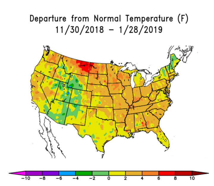
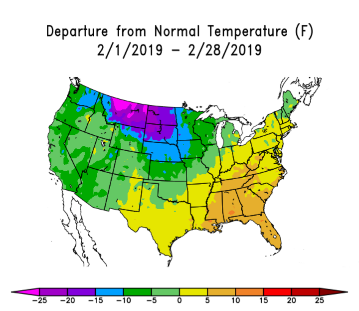
Figure 1 shows the national departure from normal temperatures for the first two months of the winter, while Figure 2 shows the national temperature departures for February. The intense cooling during February (more than 10°F below normal) covered a substantial portion of the northern and central U.S. To reiterate the cold intensity, Lincoln and Omaha had one of their top 10 coldest Februaries on record ranking 7th and 9th, respectively.
February’s cold conditions were due in part to a jet stream pattern and above normal snowfall during the month. Omaha recorded 27.0 inches, Lincoln, 23.2 inches, and Norfolk, 13.7 inches snowfall in February. Snowfall totals drop off significantly for western Nebraska during February with 6.4 inches recorded at Scottsbluff, 8.9 inches at North Platte, 11.0 inches at Valentine, and 10.9 inches at Grand Island.
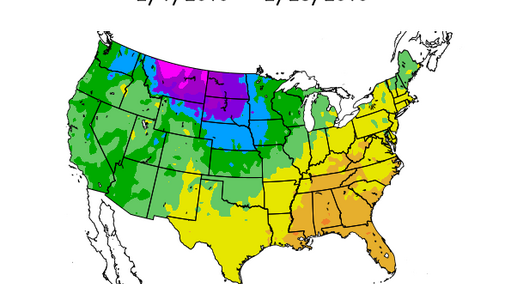
With most of southeast and east central Nebraska receiving more than 10 inches of snowfall before December started, the southeastern quarter of the state is experiencing one of its top 10 snowiest winters on record. Lincoln had received 49.2 inches by the end of February, while Omaha reported 49.8 inches. Most locations west of Grand Island have received 20-30 inches of snow, with 30-50% of it occurring in February (location dependent).
The abundance of snow, bitter cold, and high wind events has made calving season significantly more difficult than a normal spring. In fact, many of the agricultural blogs are noting that high winds, coupled with sub-zero wind chills are leading to a lot of frozen ears. I suspect that there also have been some losses due to calves freezing to death before they could dry off after birth. Although I have no numbers, I have been talking with producers after my talks and most of the discussions have centered on calving season and when will they be able to get into their fields for spring work.
So far we have escaped the mud with frost in the ground, but there is an estimated 0.50 to 2 inches of water in the snowpack across east central and southeast Nebraska and a rain event on top of this snow would lead to a significant surge of water into streams, as well as turning feedlots into mud pits.
Of course, producers are chomping at the bit to get in their fields to get preparation work done for spring planting, while also trying to incorporate fall field work that was compromised due to very wet conditions from early October through mid-November. This is a difficult prospect with such an extensive snow cover. Each day we get closer to spring reduces the number of days before spring planting starts.
Just as Arctic conditions overtook the nation’s mid-section during February, changes can be fast and abrupt. First, getting rid of the snow cover will have a modifying influence on surface temperatures. Once the snow cover is removed, soils can begin to warm up fast due to the intensity and strength of the March sun. Removal of snow alone should result in a gain of 5-10 degrees on daily highs as energy from the sun will be able to heat soils, instead of being reflected.
It is also important to remember that in late winter and early spring storms can bring either snow, rain, or a combination of both. In fact, cloudy and rainy conditions will eliminate a snowpack much quicker than a sunny day given the same air temperatures. The higher the atmospheric water vapor at the surface, the easier it is for snow to move from a solid to a gas. Therefore, you have an increase in the portion of snow disappearing into water vapor on cloudy days compared to sunny days and you get the additional benefit of melting due to temperatures being above freezing.
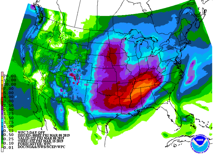
This is a perfect segue into the short-term forecast, which calls for two strong systems to impact the state over the next week. The eastern side of the storm system moving into our region this weekend indicates a mix of rain/ice/rain for the southeastern third of the state, with snow/rain/snow for much of central, north central, and northeast Nebraska. Water equivalency with this event is pointing to 0.25 to 1.25 inches of liquid equivalent moisture. Low land flooding is likely with Saturday’s event and I would not be surprised if our snowpack across the state will take a serious hit (like the early February event).
The storm system expected to arrive as early as Monday evening currently is projected to drop between 1 and 2 inches of liquid equivalent moisture with temperatures primarily in the mid-30s to mid-40s. There is a moderate risk for thunderstorms to develop, particularly with our border counties in south central and southeast Nebraska. If this materializes, we are likely to see widespread serious flooding.
To add insult to injury, another system moves into the region Monday night through Tuesday and it appears that it will also bring considerable rain to eastern Nebraska. The western half of the state has the highest likelihood of heavy snow, while northeast Nebraska has the highest potential for accumulating snowfall with this weekend’s storm.
Bottom Line
It will be a muddy mess for much of eastern Nebraska as the atmosphere attempts to rid the region of an extensive snowpack. Pay attention to lowland flood risk during the next week as two major storms cross the region, with liquid storm totals from these two systems ranging from one-half inch or less across the Panhandle to over 1.50 inches in eastern Nebraska.
Although temperature forecasts for the next two weeks point toward cooler than normal conditions, removal of the current snowpack is the first step to break the past five weeks of well below normal temperatures. In addition, once the snow is gone, the northern jet impacts should weaken as surface heating will help to mitigate Arctic surges out of Canada.
