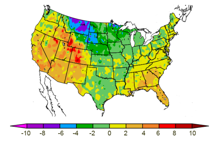
The calendar has turned to March and that means the meteorological winter has come to an end. The coldest areas of the country in terms of departure from normal temperatures were the northern Plains, with Nebraska on the southern end of this strong anomaly (Figure 1). This is even more impressive, given the first three weeks of December averaged 8-10 degrees above normal.
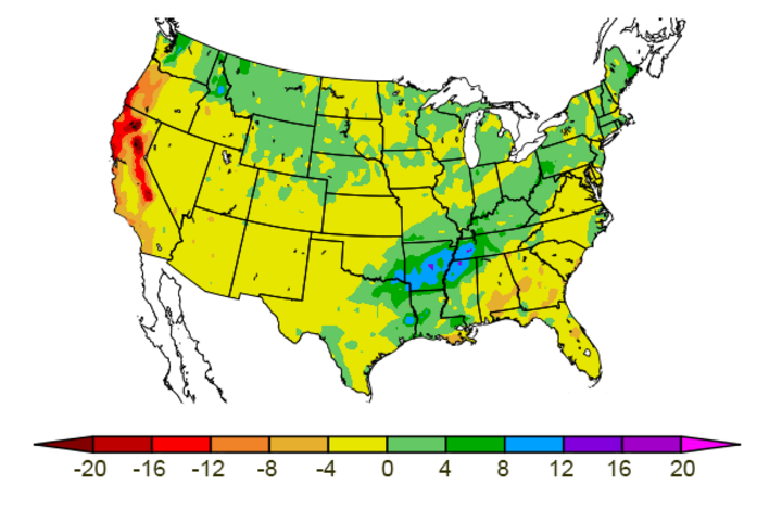
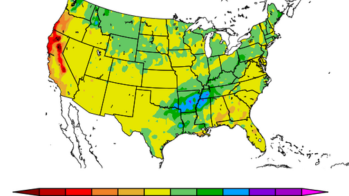
Precipitation was above normal for most of northwestern Nebraska during our meteorological winter, with the driest conditions relegated to our southern tier of counties (Figure 2). From an agricultural perspective, the standard soil moisture recharge period from October 1 to now depicts a more robust coverage of above-normal moisture (Figure 3).
Figure 3 indicates that portions of the Panhandle, southwest, and south central Nebraska are still below normal for soil recharge. Soil moisture in the southernmost tier of counties is from normal to 1-2 inches below normal while the second tier of counties north is slightly better, showing departures from normal to one inch below normal. More significant soil moisture departures have developed across the wheat-growing areas of western Kansas, Oklahoma, and Texas.
The uptick in storm activity across the western U.S. the past three weeks has brought some relief to the Sierras and southern Rockies. This week’s storm system dropped up to 7 feet of snow in the northern and central Sierras. These were impressive totals and brought snowpack to 40% of normal compared to 20% of normal before the storm.
Snowpack improvements were also noted across the southern Rockies, but not to the extent experienced across the northern half of California. Unfortunately, the climatological peak of the southern Rocky Mountain snowpack occurs the final two weeks of March in New Mexico and the first two weeks of April across the southern half of Colorado. For the Platte watershed, peak snowpack climatologically occurs the second half of April.
Further east, the active weather during the second half of February brought record monthly rainfall to extreme eastern Oklahoma, southern Missouri, Arkansas, western Tennessee and Kentucky as well as southern Ohio, Indiana, and Illinois. Extensive flooding has been reported across the lower Mississippi and Ohio River basins. Unfortunately, the key winter wheat belts of Texas, Oklahoma, and Kansas were west of this wet anomaly and there was little relief for the struggling wheat crop.
This increase in active weather from lows moving out of the western U.S. is a far cry from the cold and dry conditions that occurred east of the Rockies from the third week of December through mid-February. The latter was directly related to a strong negative phase of the Arctic Oscillation supporting a broad and persistent trough across the eastern half of the country.
The unanswered question going forward is whether this is a temporary transition to active weather like we experienced from mid-September through early October or a fundamental change in the jet stream that will usher in a more active pattern than was seen this past winter and fall. Ultimately, spring weather conditions will determine whether the drought-stressed wheat crop of the southern Plains recovers or deteriorates.
Spring Planting Forecast
Numerous issues remain unanswered going into our spring planting season and will need to be watched closely. These include the southern and central Rocky Mountain snowpack, wet conditions across the eastern Corn Belt, an increase in winter storm activity across the northern Plains, and lingering impacts of the weakening La Nina event.
Snowpack
Although recent snowfall in the southern Rockies is welcome, the cumulative snowpack isn't going to reach normal levels in northern New Mexico this year and there's less than a 10% chance southern Colorado will. Further north across the headwater region of the Platte watershed, snowpack levels are better, ranging from 60% of normal to near normal. There is still time for further recovery, but abnormal warmth going forward will limit that potential.
Snowfall across the northern Rockies, however, is poised for continued improvement. Strong winter storms the past two weeks have brought substantial moisture to the northern Plains. This should further improve the long-term drought depiction for eastern Montana and the western Dakotas. It will still take exceptionally wet conditions the next couple of months to eradicate drought conditions that developed last spring.
If snowpack continues to disappoint across the southern Rockies, I would expect a rapid increase in temperatures across the southern Plains as spring progresses. If the western U.S. pattern remains active, droughty areas will see relief. Unfortunately if the Southern Plains experience an active recovery, Nebraska will likely see a very wet spring due to the ejection of surface lows into the central U.S. from upper air troughs moving into western U.S.
If the trough pattern breaks down and we return to an active eastern U.S. trough, periodic infiltrations of artic air will continue into spring, setting the stage for a later-than-average last freeze. This pattern also can generate severe thunderstorms that have less tornadic activity, but more severe hail events.
Wet Spring
La Nina springs usually translate into an active weather pattern for the eastern Corn Belt. Heavy precipitation, such as this area has experienced the last two weeks, is common during a La Nina spring. If the troughing pattern continues for the western U.S., the lows ejecting into the central U.S. will continue to bring copious moisture as the surface lows move eastward.
If the eastern U.S. troughing pattern that dominated much of the winter returns, cool and moist conditions will continue as the southern extent of the trough interacts with warmer air over the southern U.S. The mean position of precipitation events under this pattern has favored normal to above normal moisture from eastern Montana southeastward into the northern two-thirds of Nebraska then eastward to include the western Great Lakes and the northern half of Iowa, Illinois, Indiana, and Ohio.
La Nina Shifting to El Nino
As La Nina conditions continue to weaken, global models are indicating that El Nino conditions will begin to develop by late summer or early fall. This would benefit the Southern Plains, bringing a more active jet stream pattern to the region. It would come too late for this year’s wheat crop, but would offer better starting conditions for the 2019 crop.
Summer Forecast
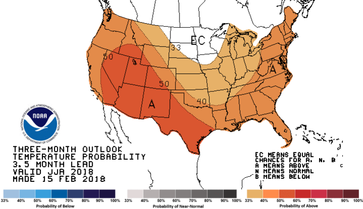
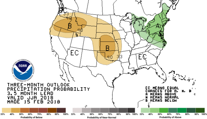
If the summer temperature and precipitation forecasts verify, irrigation demand will be well above average.
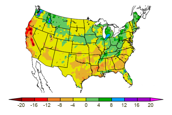
The Climate Prediction Center’s preliminary summer forecast (June-August) indicates a bullseye of below-normal moisture centered over Nebraska and Kansas. In addition, there is better than a 50% likelihood of above normal temperatures across the southern Rockies and southern High Plains. Unfortunately this leaves less than a 17% chance for above normal moisture. If the temperature forecast verifies, crop water demands will be above normal, but could be mitigated with normal precipitation. If the summer temperature and precipitation forecasts verify, irrigation demand will be well above average (Figures 4 and 5).
