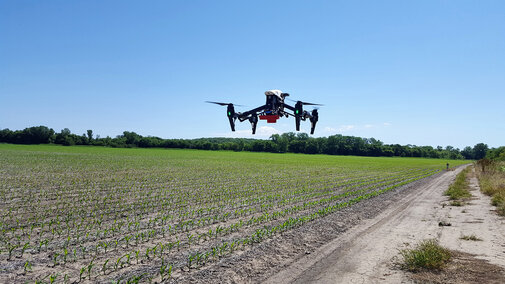
Agriculture is one of the world’s largest arenas for commercial use of drones. Farmers and agribusinesses have integrated them into crop scouting as well as more detailed sensory-based data collection. In just a few short weeks you may be wanting to use a drone or hire a drone service to fly your fields to scout stand emergence and weed management.
Agriculture is expected to be one of the largest markets for drones with a projected economic impact at over $32 billion globally — Clarity from above: PwC global report on the commercial applications of drone technology
Getting Started with Drones in Agriculture, a new Nebraska Extension NebGuide can help you integrate drones into your crop management plans. It covers drone types and sensor options and outlines a workflow for a drone-mapping project. It also includes examples of how growers have used aerial images to identify and assess field concerns such as poor stand emergence, wind or hail damage, nitrogen deficiency, and irrigation system malfunctions.
The NebGuide was written by Laura Thompson, Ag Technologies Extension Educator, Yeyin Shi, Extension Agricultural Information System Engineer, and Richard Ferguson, Extension soil fertility specialist.
Like any new technology, it takes time to learn how to use it to its fullest measure, however, it’s not too hard to get into the basics of using drones for field scouting. A 30-minute flight can scout a 40-acre field, quickly providing real-time data for decision-making. Integrate regular flights throughout the season with ground observations and you start to get a much richer, data-driven picture of your crop. The aerial images also can help direct where ground surveys are most needed to further investigate inconsistencies and determine needed management steps.
Because the resolution of drone imagery is often much higher than that of satellites, smaller features and patterns may be detected in a field. These features may not be visible in yield maps due to the lower resolution of yield maps and flow delay and imprecise calibration of yield monitors, all of which can obstruct patterns. In addition to providing timely high-resolution images when the operators wants them, drone images also can be cheaper than aerial images.
Early Season Case Studies
Two early season drone applications are to take stand counts and assess weed management.
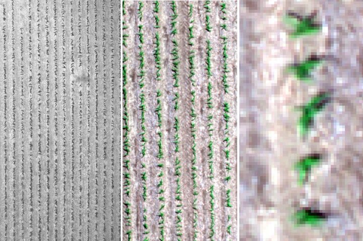
Figures 1a-c. Different uses for imagery require different resolutions. In this example, the resolution of the original flight image (a) is less than 1 inch per pixel. When the imagery is zoomed in to a specific location in the field, you can see individual rows (b) and when zoomed in further, individual plants (c).
Stand Counts. There is great interest in being able to quickly assess the early season crop stand so replant and pest management decisions can be made. Various services and products are available to assess crop stand; the quality and accuracy of these analyses may vary. Generally, these services require high-resolution images (less than 1 inch per pixel) and require flying the drone at a lower altitude. Generally, an RGB camera is adequate (multispectral sensors are not required). When considering use of these services to assess the quality of the stand and make replant decisions, ground-truthing of the information is critical.
The altitude flown determines how many images you will need to capture to adequately cover the area of interest. When flying at a higher altitude, more of the field is covered in each image, but the image resolution is lower. Resolution refers to the area on the field represented by one pixel. A resolution of 3.5 inches per pixel is a lower resolution than 1 inch per pixel. Resolution depends on both sensor capabilities and altitude. (Note: FAA regulations restrict flights to less than 400 feet in altitude.)
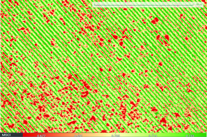
Weed Scouting. To help address the challenge of herbicide-resistant weed management, drones are used to detect and map weeds across a field. Figure 2 was captured with a five-band multispectral sensor and has a resolution of approximately 3.5 inches per pixel. The bands recorded were arranged in a proprietary chlorophyll index (MicaSense Chlorophyll Index, MSCI) and assigned a color scheme for visualization. In this color scheme, the green corresponds to bare soil between the rows of soybeans and yellow and orange represent the soybean rows (in 30-inch row spacing), while the irregular dark red spots correspond to weeds. Identifying areas with greater weed density can allow for site-specific weed management.
By flying as high as possible, the time it takes to collect images and the amount of data generated is minimized. For the examples described here, flying a 40-acre field with a five-band multispectral camera, at a 400-foot altitude, with a 70% overlap in both directions would take 20 to 30 minutes. This flight generates about 2,900 individual images and 6.8 GB of data. The resolution of the imagery is about 3.5 inches per pixel.
Follow the author on Twitter (@AgTechLaura) to view a number of drone videos taken in eastern Nebraska fields.
