April started with exceptionally cold air across a large section of the northern and central High Plains, as well as most of the central and eastern Corn Belt. Here in Nebraska, the first week saw average temperatures as much as 20 degrees Fahrenheit below normal, while western Nebraska averaged 8-15 degrees below normal. These are the types of temperatures we would expect at the start of March, not April.
Thankfully, the brief period of above-normal temperatures that developed this week across the state gives us hope that the worst of the cold conditions are behind us. Average daily 4-inch bare-soil temperatures rose 3-5 degrees on Tuesday across western Nebraska, with temperatures approaching the upper 40s across the southwest and west central sections of the state. Eastern Nebraska experienced a 2-3 degree rise in soil temperatures on Tuesday, with most locations in the upper 30s to low 40s. (See daily soil temperature updates.)
Most locations in the state will flirt with or exceed a 50°F four-inch bare soil temperatures by Friday. This should put 2-inch soil temperatures in the mid to upper 50s. Unfortunately, this warm-up will be short lived as an exceptionally strong spring storm system is poised to cross the Corn Belt this weekend. Heavy snowfall is likely from the Dakotas eastward through the Great Lakes region. This places the northern third of Nebraska on the southern periphery of the heavy snowfall band.
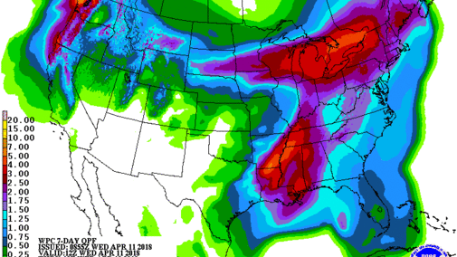
Although quantitative precipitation forecasts for this system indicate 1-3 inches of liquid moisture (Figure 1), the brunt of extreme precipitation is projected to hit the Great Lakes region. There will likely be a sharp precipitation gradient with this system, as the southern third of the state is projected to receive less than 0.50 inch of moisture. If the models are correct, we will experience temperatures below 50 this weekend before temperatures rebound into the 60s as early as Tuesday.
Looking further into the future, another strong storm system is projected to develop late next week and bring active weather to the state next weekend. This, unfortunately, has been the dominant pattern since late February. The good news for now is that the models keep the cold air north of Nebraska, so precipitation should be in the form of rain and thunderstorms.
If models maintain the strength, timing, and track of this system, additional snowfall is likely across North Dakota, northern Minnesota, northern Wisconsin, and northern Michigan. Further south, heavy rainfall is likely for the central Corn Belt, including eastern Nebraska through Illinois.
If we are to look at the positive aspects of these early spring storm systems, two key thoughts come to mind. The cool conditions are delaying spring green-up of native vegetation, which increases the likelihood that soil moisture reserves will benefit across the southern half of the state where soils are drier. Second, this recent stretch of cool weather is extending the snow season in the central Rockies, which should temporarily halt further degradation of the central Rockies snowpack.
In summary, it appears that the worst of the cold that settled over the Corn Belt the past two weeks is coming to an end. However, with warmer temperatures, our chances for severe weather will increase as an active precipitation forecast is projected through late April. The worst of these conditions are expected to occur across the northern, central, and eastern Corn Belt. At least for the southern half of Nebraska, it does appear that temperatures will be more favorable for spring planting as long as forecasted precipitation events don’t produce excessive rainfall.
