
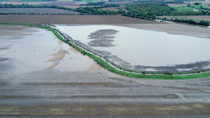
Precipitation UpdateAl Dutcher, Associate State Climatologist, Nebraska State Climate Office: Based on NERain data for the week prior to Oct. 11 the heaviest rainfall with this system occurred south and east of a line from the southeast corner of Jefferson County through northern Nemaha county. Storm totals ranged from 4 to 6.55 (Julian area) in this area.
Storm totals ranged from 1.50 -3 inches south of a line from SW Hitchcock county to Yankton, S.D, with isolated pockets of 3-4 inches in the Red Cloud, Curtis, and West Point areas. Storm totals of 0.75-1.50 inches were common for the remainder of the southwest corner of the state, as well as the southern Panhandle, the extreme northeast Panhandle, and the western Sandhills. The remainder of the Panhandle was generally in the 0.15 to 0.50 inch range, with isolated totals approaching 0.75 inches.
The maximum 24-hour precipitation reported during this event was 2.38 inches near Osceola 6.9 miles north of Osceola, falling from 7 a.m. Oct. 9 to 7 a.m. Oct. 10.
Here are the 24-hour totals ending at 7 a.m. for each day that this storm event impacted the state:
10/5 1.62 inches 1.2 miles southwest of Curtis
10/6 2.11 inches 3.8 miles southwest of Table Rock
10/7 1.90 inches 4 miles southwest of Cook
10/8 2.05 inches 3.5 miles east-southeast of Julian
10/9 1.90 inches 7.2 miles southwest of Humboldt
10/10 2.38 inches 6.9 miles north of Osceola
According to the NERain and Cooperative observer reports received so far, snow storm totals were 5 inches around Ellsworth and 4 inches in the Kilgore area. The remainder of totals reported were in the 1-3 inch range.
Randy Pryor, Extension Educator in Saline County: Harvest was going fast and furious until rain started last week. Beans are hanging on pretty wet, particularly in southern Gage and Pawnee counties. Dryland yields are variable, depending on whether they got rain at key times; some dryland yields are disappointing. There have been reports of 105-115 bu/ac near Wilber/Dewitt and 160-180 bu/ac in northern Saline County and near Liberty. We’ll have tremendous irrigated yields if the corn stays standing. Those producers practicing continuous no-till will be able to get back in the field faster after the rain. (10/9/18)
Michael Sindelar, Extension Educator in Clay County: Growers here are facing rain and cold weather as they try to get things out. A lot of beans are out, but we still have a lot of standing corn. Some excellent dryland corn yields have been reported. (10/9/18)
Aaron Nygren, Extension Educator in Colfax, Cuming, and Stanton Counties: Growers here have made some progress on harvesting corn, but slow progress on beans. Good yields have been reported near Columbus, despite some hail damage. With stalk rot worsening by the day, it's likely to take some time to get the crop out. Plants where fungicide was applied seem to be holding together better, although some tops went down in the wind. (10/9/18)
Sarah Sivits, Extension Educator in Dawson County: Harvest was at a standstill last week and growers are getting a little antsy. Near Elmwood we had over 1 inch of rain last weekend and some plant tops went down in the wind. (10/9/18)
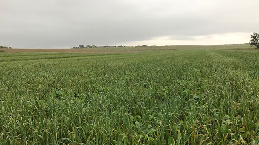
Troy Ingram, Extension Educator in Valley, Greeley, Sherman and Howard Counties: In the last week we got 1.25-1.75 inches of rain. About 25% of our corn and 40% of our soybeans are harvested. Stalk quality is an issue here as well. Some drills are already out, chasing the combines to get cover crops planted before there are more rains. Aerial seeding cover crops may be a good option this year. (10/9/18)
Kat Caswell, Extension Educator for Red Willow, Hayes, Frontier, and Hitchcock Counties: Last week we got 0.25 inch of rain with more Monday. We still have a lot of corn to harvest. Earlier this season dryland corn was looking really good. More than 50% of our wheat has been planted and a lot has emerged. Those who got it in before the rain are lucky. (10/9/18)
Jenny Rees, Extension Educator for York County: About 70-75% of our beans and 40% of our corn has been harvested. Growers started harvest early in hail-damaged fields. Growers here are paying attention to stalk quality and switching between corn and beans, getting after some of the same hybrids that were dropping ears or had weaker stalks last year. Stalk quality has just disintegrated, even on plants with a fungicide treatment. There have been a lot of questions about grain molds and I posted a blog on grain condition and storage with photos to aid in the identification of different molds. We have fusarium, fumonisin, and vomitoxin, particularly in fields with hail and/or insect damage. There have also been questions about grain moisture, drying and grain storage. (10/9/18)
Amit Jhala, Extension Weed Scientist: Conditions have been very conducive to weed as well as cover crop emergence. Marestail, pennycress, henbit are emerging. The best time to control marestail is in the fall. (10/9/18)
Steve Melvin, Extension Educator in Merrick County: A lot of fields from Hall to Hamilton and Merrick counties that sustained significant hail damage around Sept. 1 have been harvested. (10/9/18)
Wayne Ohnesorg, Extension Educator in Madison County: Harvest is a lot further behind in this area compared to other areas of the state. Only about 10% of the soybeans and 1% of the corn has been harvested. They were still chopping silage within the last couple weeks, chopping it dry, even for silage. The rain hasn’t been overwhelming, but it's been enough to keep people out of the field. (10/9/18)
John Wilson, Extension Educator in Burt County: Less than 20% of our corn and beans are harvested. We had about 1 inch of rain over the weekend. Some farmers on poorly drained fields are anticipating having to wait until ground freezes, particularly along Missouri River bottomlands. (10/9/18)
Gary Lesoing, Extension Educator in Nemaha County: About 50% of the corn and 10% of the soybeans have been harvested here. More has been harvested in Richardson County where they’ve had drier conditions this summer. Yields have been quite variable with some excellent yields at 250 bu/ac and some very poor yields in drought areas. Some soybeans have been harvested at 50-60 bu/ac, but a lot haven't been harvested. Wet weather has really slowed down harvest. (10/9/18)
Megan Taylor, Extension Educator for Platte County: The weather has kept some growers parked over the past several days. Many are interested in learning more about temporary storage for soybeans and what is best (ag bags, etc.). Also, many ear rots and stalk rots are persisting, mostly anthracnose and gibberella. (The Grain Storage Management section of CropWatch has information on temporary or emergency grain storage options, including alternative grain storage.) (10/9/18)
