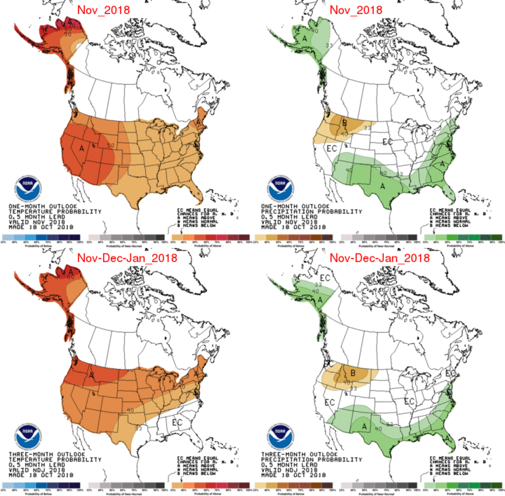
Certainly, the last month has been a challenge for producers to get their crops harvested in a timely manner. Precipitation has been problematic the past two months, with periodic bouts of extended heavy rain at the end of August into early September and late September into mid-October. This recent stretch of dry weather has finally been long enough for the soybean harvest to make significant progress.
The USDA National Agricultural Statistics Service crop progress report for Nebraska indicated that 54% of the state’s soybean crop had been harvested as of October 22, compared to 38% the prior week. With three additional days of good harvest weather before our midweek precipitation event, expectations are that at least 75% of the soybean crop will have been harvested by Monday’s NASS update.
Models are once again indicating the potential for several systems that could impede harvest progress. At present, computer models are pointing to a system working southward out of the northern Plains Saturday night through Sunday morning with light precipitation (
A more robust system is projected for Halloween, although the models are flipping in regards to where the most significant impacts will fall. The average of the model runs the past several days points to eastern Nebraska and western Iowa as receiving the heaviest moisture, with the potential of 0.25 to 0.50 inch or more across east central and southeast Nebraska. Temperatures could be could enough at the end of the event for a snow/rain mix.
Looking further down the road, weather models indicate a strong storm system developing Nov. 5-7 over the central U.S. from a large upper air trough projected to swing into the northwestern U.S. Depending on the amount of cold air, accumulating snowfall is likely in the eastern northern Plains through the upper Mississippi River valley. A reinforcing shot of cold air is then projected to move through the region Nov. 9-10, with arctic air and the chance for light snow.
The good news with this active pattern is that no sustained period of bitter cold weather is forecasted through November 5, so the oscillation between distinct cold and warm periods is likely to continue through the remainder of the month as the northern and southern jet streams battle it out for dominance heading into winter.
If the current El Nino follows script, the southern jet stream should continue to strengthen at the expense of the northern jet. We are seeing signs of this evolution presently, as heavy moisture has returned to the southwestern U.S., as well as the southern Plains and much of the southeast. The northern jet stream has concentrated most of its energy east of the Continental Divide, with cold air penetrating southward from the northern Plains through the western Great Lakes.
Approximately 70% of the El Nino events will be dominated by the southern jet, while the northern jet weakens and remains far north of its mean winter position. Under this scenario, the best wet conditions are likely at the beginning and end of the winter season, when the northern jet has a better chance of exerting its influence as the southern jet slowly strengthens. The late winter storminess is a product of the typical El Nino decay, increasing the strength of the northern jet and weakening the southern jet.
If this pattern fails, then what is occurring with our northern jet will play an important role as we move forward. The number of cold air intrusions and subsequent precipitation events will be determined by the strength and position of the Hudson Bay upper air low. If this low is stronger than normal, frequent arctic intrusions into the continental U.S. would be favored from the eastern Plains through the northeastern U.S. If it is weaker than normal, the most favorable area of cold air penetration on a regular basis would be the upper Great Lakes and northeastern U.S.
The bottom line is that we are about a month away from seeing what pattern will likely dominate our winter season. In the meantime, it appears that cooler temperatures and a more active pattern will occur the next two weeks. If the past two months are any indication, an extended period (7-14 days) of drier and warmer weather should develop during the second half of November.
