We are now two-thirds of the way through our meteorological winter (December-February) and it is time to take stock of how the current upper air pattern will likely influence the remainder of our winter and whether these conditions will carry over into the first half of our spring season.

A substantial portion of the western U.S has seen a steady progression of storms kicking out of the Gulf of Alaska and a major reduction in land area in drought during the last eight weeks.
Last fall was dominated by above normal temperatures and large areas of below normal moisture across the contiguous U.S. Much of eastern Colorado, western Kansas, southwest Nebraska, and the panhandles of Texas and Oklahoma received less than 25% of normal moisture. A more extensive area of dry conditions enveloped most of the southeastern U.S. Recent storm activity has reduced the areal coverage of drought across the southeast, however, the remaining drought area still shows dryness from one month to one year in length.
The real precipitation winner so far this winter has been the area west of the Continental Divide and south of the Pacific Northwest states of Oregon, Washington, Idaho, and western Montana. A non-stop succession of storms has brought incredible snow totals to the Sierras and the upper Colorado River basin region of western Colorado and eastern Utah. The latest snow data from the Natural Resources and Conservation Service (NRCS) indicates that the two basins are running nearly 200% of normal.
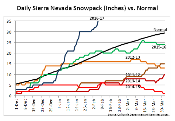
An easier way to look at the impacts of these storms on the Sierra snowpack is to examine the latest estimate of snow water averaged for the entire Sierra region of California. Current estimates provided by the Climate Prediction Center (Figure 1) show an estimated 35 inches of snow-water equivalent for the average of snow monitoring locations throughout this mountain range. In an average year, the snow water content peaks at 30 inches during the first half of March.
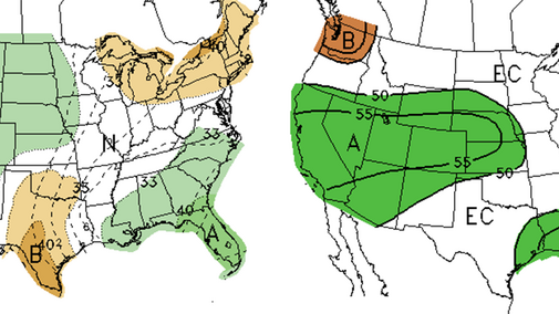
Numerical weather models continue to indicate that another series of storms are poised to make landfall by the middle of next week. The storms hitting the west coast this week are likely to increase the snow water equivalency to 40 inches and next week’s storms could move these values into the 45-inch range. The one fly in the ointment would be if these forecasted storms have enough warm air to keep moisture in the form of rain instead of snow. Snowpack water equivalencies would decrease, but significant flooding from melting would likely occur. Longer term forecasts indicate continued chances for above normal precipitation for many areas of the US, including Nebraska (Figures 3-4).
Nebraska Forecast
If 50% of these events produce moisture similar to the pattern the past two months in Nebraska, very wet conditions are likely through mid-April.
Nebraska has benefitted from the succession of storms entering the United States. Although seasonal snowfall totals are well below normal across the southern half of the state, precipitation since early December has been above normal statewide (Figure 2). Most of the precipitation received statewide has been liquid or freezing rain, except in north central and northeast Nebraska where they’ve seen a strong uptick in accumulating snowfalls the past three weeks.
By my count, approximately three out of every four storms hitting the west coast have lifted northeast into the western Great Lakes, leaving the drought area of the southeastern U.S. well south of the main precipitation shield. About one storm out of four is crossing this drought area. Although some improvements have been noted during the last 60 days, a large area of D2 (severe drought) still exists. In order to eliminate this drought area before spring planting it would take a foot or more of moisture above the normal expected 4-8 inches.
Looking at the various forecast products that are available at the Climate Prediction Center, mid-range forecasts (8-16 days and the experimental 3-4 week outlook) point toward above normal moisture from California moving east-northeast through the central Plains, which includes Nebraska and Kansas. If short-term models verify, I would expect that frost in the ground will likely disappear across the southern half of the state before stormy conditions take shape during the second half of February.
At this point most of the moisture has fallen on frozen ground. Runoff has been significant enough that we are getting reports out of the southern third of Nebraska that stock ponds have filled completely or recovered to the point that water shortfalls are not an immediate concern. If storms materialize during the second half of February, I would expect soil moisture will improve heading into early spring.
If the storm activity continues for the western U.S. as currently projected and the trend doesn’t break once March arrives, I expect that Nebraska will see a complete removal of any drought signature (including abnormally dry conditions) before spring warm season crop planting gets underway in April.
The weather station at the Omaha Epply Airport reports 29 out of a possible 62 days with a trace or more moisture since December 1. As air temperatures warm, the atmosphere will be able to hold more moisture and the magnitude of individual events should increase. If 50% of these events produce moisture similar to the pattern the past two months, very wet conditions are likely through mid-April.
