Planting is underway in Nebraska but briefly stalled mid-week due to several storm fronts moving through. As of Monday 3% of the state’s corn crop was in the ground, compared to 6% last year, and equal to the five-year average of 3%, according to the National Agricultural Statistics Service reported
Planting weather was ideal Monday-Tuesday (April 17-18) for most of the state, if soils were dry enough to tolerate machinery; however, active weather Wednesday and Thursday (April 19-20) caused temporary delays across the eastern third of the state. Areas along and south of I-80 from York westward missed most of this inclement weather and planting gains in next week’s NASS report will be heavily weighted to this region of the state.
Another storm system is predicted to roll across the central United States this weekend. Current projections place the majority of moisture across the Panhandle and southwestern corner of the state as the system emerges on to the High Plains from western Colorado. Current projections indicate 0.25 to 0.50 inches with this event, with the heavier moisture moving across the northern half of Kansas.
If this weekend’s storm system maintains its present forecasted track, dry conditions should hold until the middle of next week. This would provide our longest stretch of dry weather since late March and provide a substantial boost to the number of planted corn acres in the next two NASS releases. However, if the track of this system moves north 50 miles, the southern two tiers of counties would face a couple days of planting delays.
This forecast window is very important as numerical weather models indicate that an aggressive storm pattern will once again develop across the central United States beginning the second half of next week through the first weekend in May. If the modeled trends verify, significant planting delays are probable for much of Kansas, Nebraska, the Dakotas, Minnesota, and Iowa.
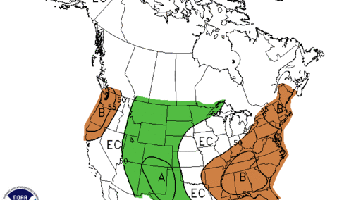
The two- to four-week outlook issued by the Climate Prediction Center for April 29 – May 12 (Figure 1) indicates above normal moisture for the western half of the High Plains region from Texas to Nebraska. To our north, North Dakota, South Dakota, and Minnesota also are projected to receive above normal moisture. Below normal moisture is indicated from eastern Oklahoma through the southeastern U.S., areas east of the Appalachian Mountains, and the southern half of the eastern and central Corn Belt.

