Convection this week has brought welcome moisture to areas east and south of Grand Island, as several complexes developed on a daily basis from June 24 to 26. Unfortunately, a substantial portion of northern and western Nebraska missed out on these events and a substantial increase in abnormally dry conditions is depicted on this week’s Drought Monitor (Figure 1). Rainfall reported after 7 a.m. on June 27 will be incorporated in next week’s edition.
Short range numerical models bring additional chances for moisture to the eastern half of the state from Sunday night (July 2) through Tuesday morning. As the ridge from the west builds eastward, models indicate that energy will ride down the front of the ridge and support the development of a convective complex that will push southeastward through the state. This may offer the best chance of moisture for northern Nebraska through next weekend.
If substantial rains in excess of 2 inches fail to materialize, there is a strong possibility that moderate drought conditions will be introduced across portions of the eastern Sandhills and northeast Nebraska next week. The target area for upgrade would be centered at the intersection of the Niobrara and Missouri rivers and southward up to two counties.
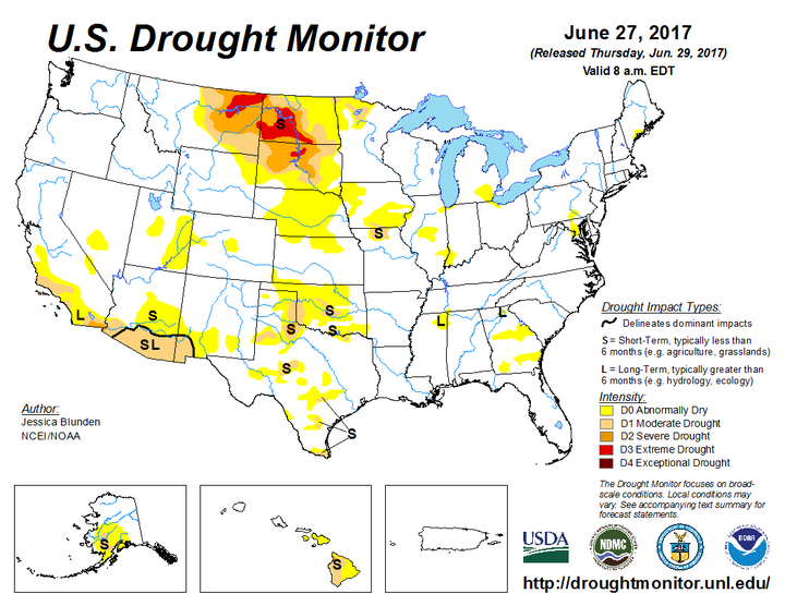
Some improvements are likely on the eastern extent of the abnormally dry region of central and south central Nebraska. Tuesday’s moisture brought 1-3 inches east of Grand Island along the I-80 corridor and is likely sufficient to eliminate abnormally dry conditions in the short term. The other area where we may see a decrease in abnormally dry conditions is in northern Franklin and southern Webster and Nuckolls counties where they received 2-3 inches of moisture Wednesday night.
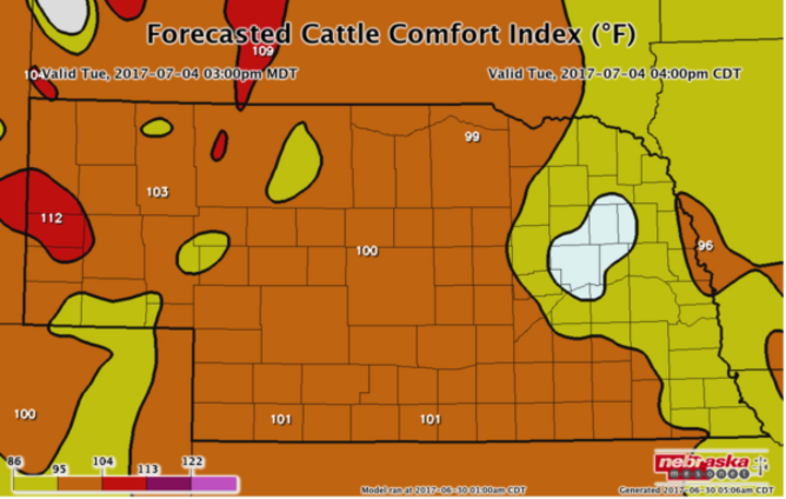
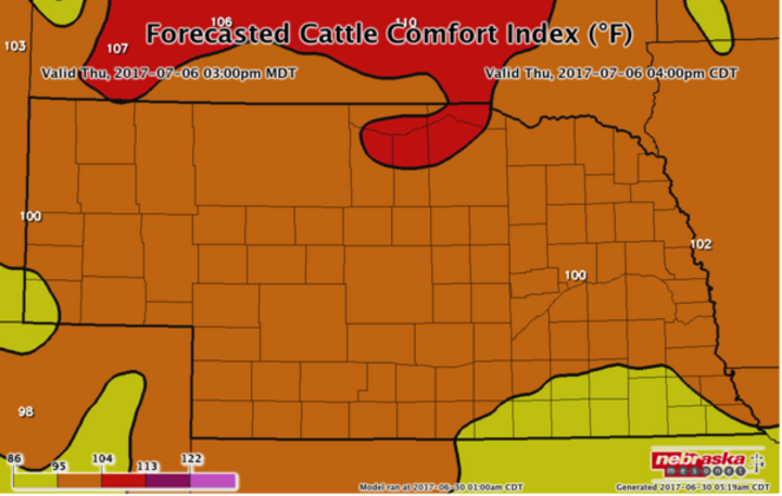
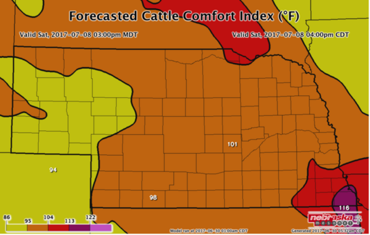
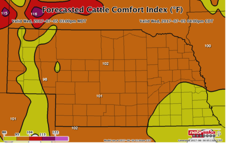
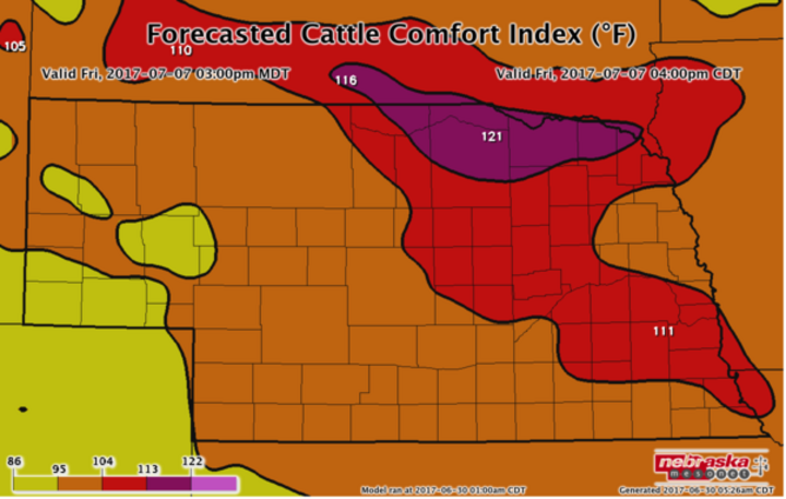
Looking at current model projections, a large ridge will build eastward next week. Temperatures will return to the 90s by July 5, with middle to upper 90s possible July 7-8. Unfortunately, humidity levels will be high and human heat index values are forecasted to exceed 105°F. The Cattle Comfort Index (Figure 2) indicates high to extreme stress values on July 7. High stress values of 113-120°F are projected for the eastern half of Nebraska with the highest values assigned to northeast Nebraska.
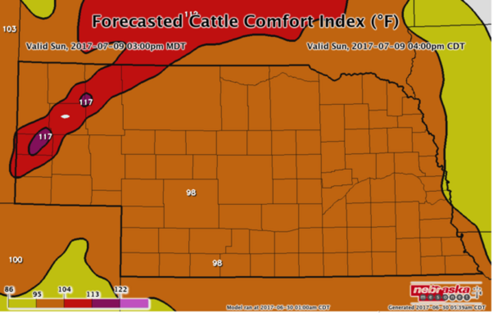
Even though high stress values are indicated for July 7 across eastern Nebraska, models indicate that cattle stress index values will be between moderate and extreme levels from July 4 to July 9. The latest model runs continue to keep the ridge over the central US through July 15 so we appear to be entering another long stretch of 90°F or greater heat.
Forecasted Cattle Comfort Index (°F) July 4-9
(Source: Nebraska Mesonet, Nebraska State Climate Office)
Models hint at possible episodes of convection as monsoon moisture begins to move from the southwestern US into the central Rockies July 10-16; however, my confidence that this will verify is very low. With upper level ridging in place, the atmosphere may cap convective development. What is more certain is that we are entering a period of warm temperatures that will likely coincide with the onset of pollination. Irrigation demand will be high and crop stress will increase without sufficient moisture relief in those areas that have missed out on rainfall events since the beginning of June.
