The Climate Prediction Center (CPC) released its May and seasonal forecasts on April 20, slightly modifying its previous forecast for above normal precipitation for the western half of Nebraska through early fall. This shouldn’t come as a major surprise considering the roller coaster ride we have experienced with precipitation the past few months.
In the short term, CPC indicates that the May precipitation outlook (Figure 1) calls for above normal moisture across the northern Rockies and the western Dakotas. Below normal moisture is indicated for the Great Lakes region including Illinois, Wisconsin, Michigan, Indiana, eastern Iowa and Missouri, as well as northwestern Ohio. Nebraska is shown with equal chances of above normal, normal, or below normal moisture.
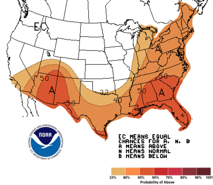
Temperature outlooks for May (Figure 2) depict above normal temperatures for the southwestern U.S., Texas, and areas east of a line from southeast Arkansas through the lower peninsula of Michigan. The highest probabilities of receiving above normal temperatures have been assigned to the southwestern U.S. and Florida. The remainder of the country is forecasted to have equal chances of above normal, normal, or below normal temperatures.


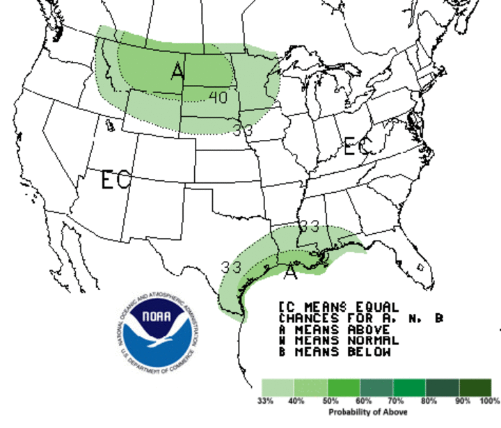
Precipitation outlooks for May through July (Figure 3) point to above normal moisture for the northern Rockies, all of the Dakotas, the northern half of Nebraska, northwest Iowa, and all but the southeastern corner of Minnesota. Another area of above normal moisture is depicted for the Gulf Coast region from eastern Texas to the western half of the Florida Panhandle. Elsewhere, equal chances of above normal, normal, or below normal moisture are depicted.
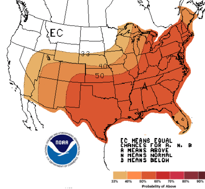
Temperatures for May through July (Figure 4) are expected to be above normal for the entire country east of the west coast and south of the northern High Plains. Nebraska sits on the northern fringe of this above-normal temperature projection area, with the highest probabilities of warmer than normal temperatures depicted south and east of a line from Denver to St. Louis to the Saginaw Bay area of Michigan.
The CPC's seasonal outlooks shrink the above-normal precipitation area from the Pacific Northwest through the western half of the northern Plains to the central and northern Rockies. The new outlook for the June-August and July-September period depicts above normal moisture for all of the Rocky Mountain region, including the western quarter to third of Nebraska. CPC has backed off its forecast for above normal moisture for western Nebraska during the August-October period, but kept above-normal moisture conditions in the Colorado and Wyoming forecasts.
Although temperatures are forecasted to be above normal for most of the country through this fall, the lowest probabilities have been assigned to the central and western Corn Belt. The northern Plains, including the northern half of Nebraska, have been assigned equal chances of above normal, normal, or below normal temperatures from June through August. However, the Nebraska forecast for all periods from July-September to December-February shows above-normal temperatures.
If the seasonal precipitation forecasts verify, irrigation demands will likely be below normal this season as precipitation offsets crop water use. Of course the flip side of this equation is that hail risk from thunderstorm activity would increase due to thunderstorm development along the front range of the Rockies. CPC’s depiction of above-normal moisture for the Rocky Mountain region through the first half of this fall would suggest that the southwestern Monsoon season will likely be stronger than normal.
